


The Road Less Travelled: Innovative Digitisation of a Mountain Road with the Leica Pegasus:Two Ultimate
Case study

Raphael Goudard, Business Manager for Mobile Mapping solutions
The alpine roads in Berchtesgadener Land, Germany, offer some of the most breathtaking views in the world. As the gateway to tourist areas in the southeastern tip of Bavaria, it’s vital to the local economy that the roads are kept in a good condition. The responsibility for that falls to The Traunstein State Building Authority (TSBA). TSBA manages the alpine roads in addition to a network that includes hundreds of kilometres of federal and state roads, walking and cycling paths, bridges, support structures and tunnels. A pioneer in using digital methods, TSBA wanted to create a digital record of the area as a basis for planned construction work. The Authority asked Ing Geovision, surveying and geospatial data management experts, to survey a 3.2 km stretch. After exploring options, Ing Geovision used a Leica Geosystems mobile mapping solution to digitally capture the road and its retaining walls. The project was the first time that mobile mapping had been applied to this type of challenge.
Challenging physical constraints for data capture

With a 23% slope in some places and huge drops into the valley below, the roads in Berchtesgadener Land are not easy to survey. It’s particularly difficult to access both sides of the retaining walls, as they are built on steep, heavily overgrown terrain. Due to the altitude and remoteness there was a weak GNSS signal over almost the entire distance, especially in the five tunnels included in the survey area. On top of the physical constraints, the survey also needed to be carried out quickly. The road could not be closed or blocked for long, to keep the route free for tourist buses. Nevertheless, because the data obtained from the survey was to be used as the basis for planned construction work, the road and walls needed to be recorded with the greatest possible accuracy.
Mobile mapping met all the project evaluation criteria
The Ing Geovision team are highly experienced in holistic surveying. They have been the digitisation partner for buildings, plants and other infrastructure in more than 1,000 successful laser scanning projects. For the Berchtesgadener Land project, they considered various methods: laser scanning via a drone, tachymeter measurement, a static scan and mobile mapping. The evaluation criteria included time spent on site, accuracy of the data, ability to detect the retaining walls and the road condition in high resolution. Finally, whether the method could be used to gather photo documentation and point cloud data in one operation.
A drone was ruled out because it could only deliver photos, tachymeter surveying because it couldn’t deliver photos or point cloud data. A static scan would take too long and couldn’t be positioned on the outside of the walls in many places. Although untested in this scenario, mobile mapping was able to deliver on every criteria. Mobile mapping systems combine sophisticated hardware sensors and software technologies to take laser scanning off the static tripod, letting the team capture accurate 3D data by car.
Unconventional attachment of the scanner solved the site access problem
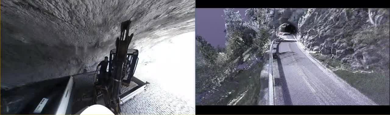
Ing Geovision put together a scanning solution using the Leica Pegasus:Two Ultimate mobile mapping platform. Ingeniously, in order to capture both sides of the retaining walls the Leica Pegasus:Two Ultimate was not only mounted to the roof of a car, but also to the bucket of an excavator. This allowed the scanner to hang over the edge of the wall and capture the exterior, with no risk to human safety. Measurement of control points was done by a tachymeter TS16 and the tunnels were additionally scanned using a static RTC 360, in order to look for a historical drainage system. The data was evaluated using Leica Pegasus:Manager, Leica Cyclone and Leica Cyclone 3DR.
Delivering fast and flexible scanning


Kontaktaufnahme mit Leica Geosystems
Hier finden Sie Ihren Leica Geosystems Ansprechpartner für Vertrieb, Support und technischen Service.
Hier finden Sie Ihren Leica Geosystems Ansprechpartner für Vertrieb, Support und technischen Service.

Leica Pegasus:Manager
Efficient, easy workflows, from mission planning to batch extraction and Jetstream collaboration to online web-sharing
Efficient, easy workflows, from mission planning to batch extraction and Jetstream collaboration to online web-sharing