


3D Laser Scanning in automated monitoring projects with the Leica Nova MS60 MultiStation
Advance your monitoring workflows

Leica Geosystems’ scanning in monitoring solutions are used by surveyors and organisations across the world to measure the potential impact of nearby construction and natural hazards on buildings and infrastructure.
From monitoring the safety of a commuter rail line in Dublin to surface deformation in Singapore, every project presents unique challenges and opportunities for surveying service providers to develop and expand their services, backed by Leica Geosystems’ expertise and innovations in precision measurement technology.
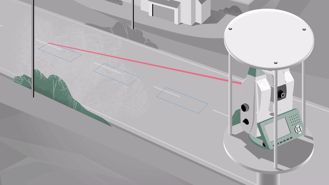
The revolutionary merging of Leica Geosystems’ 3D laser scanning and automated total station technologies has led to a significant advance in monitoring capabilities. For example, when detecting road movements using single reflectorless points, incorrect results may occur from live traffic interruptions. Laser scanning overcomes this problem, as data-rich patch scans provide accurate surface measurements of busy highways, increasing efficiency and safety without the need for road closures or diversions. Contractors tasked with monitoring busy highways during construction benefit from the method to continuously collect data without halting the flow of traffic on always busy roads. With limited access to the road and the safety of drivers and staff a priority, the monitoring system is fully remote and can run autonomously 24/7 over several years.
Scanning in Automated Monitoring – A Unique Solution
Automated monitoring with Leica Geosystems’ 3D laser scanning was introduced in 2013 with the launch of the Leica Nova MS50, the world’s first MultiStation, a robotic laser scanning total station. Updates to functionality and scanning capability heralded the release of the Nova MS60. Used in conjunction with Leica Geosystems’ GeoMoS software suite, this remains the only automated scanning solution available for monitoring.
Using automated total stations for prism and reflectorless measurements to define points plus 3D laser scanning on focused areas of interest provides an optimal, data-rich perspective for monitoring deliverables. This enables businesses to stay competitive by expanding their portfolio of services to include measurement of hazardous or previously inaccessible areas.
Automated monitoring projects typically use prisms outside the area of deformation as survey control and inside the area to track movements of specific points. By incorporating 3D laser scanning to the workflow it is possible to read between the lines and compare timed measurement scans with baseline reference datasets, enabling autonomous deformation detection. Notifications can be triggered and instantly communicated to decision-makers if tolerance thresholds for movement are exceeded, and corrective action required.
SEE HOW LEICA GEOSYSTEM'S SCANNING IN MONITORING SOLUTION SOLVES THESE ISSUES FOR SURVEYORS:
3D laser scanning brings versatility to monitoring projects, significantly enhancing data collection compared with the single reflectorless measurement technique. Mass data from scans adds reliability and quality assurance to a project.
Scanning in monitoring solutions are rooted in Leica Geosystems’ product development innovations for the acquisition, management and analysis of geospatial data. Every monitoring project might differ in scope, environment, and type but the requirement for accuracy and reliable information is always vital. The addition of 3D laser scanning, together with Leica Geosystems’ support and training, delivers an unsurpassed option for enhanced and comprehensive monitoring, and here’s why:
1. Simple and Quick to Set Up
The MS60 is a total station and a laser scanner in one instrument, therefore measurements to an infinite number of targets are possible and recorded data is not limited by the number of prisms and reflectors. With the Leica MS60 and the GeoMoS monitoring solution, the area to be scanned is defined by shape, size and frequency. There is no need to find discrete points or seek access to install additional prisms as measurements are taken via scans, saving time and costs. Scanning provides a reliable contactless and non-intrusive solution for an increasing number of monitoring projects and is especially useful in situations where installing prisms would be impractical, dangerous, prohibited, costly and potentially damaging.
2. Easy to Maintain
Scanning optimises the number of prisms required so saving time and money on installation and checking and cleaning during operation. It is also a non-invasive technique so when the job is completed, the de-commissioning process is straightforward and fast. With fewer prisms to remove and no surface damage to repair the monitoring instrumentation is available, portable, and ready for use on the next project.
3. Comprehensive and Reliable Data
Unlike single reflectorless measurements, the MS60 can define a scanning patch of an area to be monitored and capture thousands of points per second. With this amount of data, GeoMoS automatically calculates the median value of the patch using special algorithm technology. In addition, the Leica MS60 has a high-resolution dual-camera imaging system which can automatically capture images with each scan. MS60’s sensor fusion allows monitoring professionals to visualize deformation information in GeoMoS, including heat maps, graphs and tables and to make informed decisions as required.
4. Optimising Your Investment
The MS60 with GeoMoS scanning module is an empowering, multi-functional combination for enhanced data capture. Frequently, monitoring projects require hybrid measuring techniques so the solution can be used for prism monitoring only, or a prism plus scanning option at any stage without the need for further investment in additional hardware. Even when a project requires scanning of unplanned areas the MS60 takes just minutes to define a patch and be automatically incorporated into the monitoring workflow. The versatility and flexibility of a monitoring solution incorporating scanning is scalable from short-term projects, to software options developed for advanced monitoring initiatives using different sensors.
5. Data-Rich Results
The MS60’s advanced sensor technology merges automated scanning, imaging, reflectorless and prism measurements, providing holistic information for accurate detection of movement with GeoMoS. The quality of monitoring data is critical to better understand the impact of deformation, and having the capability to produce such a data-rich output increases confidence in the reliability of the results.

Scan area deformation heat map, overlaid with an image taken by the Leica MS60 MultiStation
Be Inspired!
Customers around the world have implemented Leica Geosystems’ solutions in projects that show the benefits of adding scanning to the automated monitoring of urban areas, highways and rail infrastructure, heritage buildings and more. Learn below how some of these inspirational projects are taking monitoring workflows to the next level.

Monitoring Dublin commuters' safety
With 67 stations and 42.5 kilometres of track, Dublin’s Luas light rail system safely carries over 40 million passengers per year. In 2018, a north section of Luas rail was in the vicinity of the construction activity of a group of commercial buildings. To reduce risk to infrastructure, early and precise monitoring was necessary. Continuous scanning of the dual railway tracks using Leica Geosystems' robotic MultiStation the MS60 ensured commuters' safety in Dublin.

With ongoing construction work, monitoring of heavy traffic roads, tunnels, and nearby areas is of paramount importance to ensure minimal deformation or disturbance occurs. Using Leica Geosystems’ monitoring solutions, the Singapore Land Transport Authority was able to set up an Automated Road Monitoring System covering a two-kilometre critical stretch of the Seletar Expressway affected by drilling of the Tunnel Boring Machines (TBM) underneath. Learn how scanning in monitoring enhanced productivity as an unmanned measuring system.

Cultural heritage buildings and structures can be monitored using 3D laser scanning without the need to install prisms that could cause surface damage. Scanning with the Leica MS60 gathers monitoring data for real-time or periodic measurements of valuable structures.
For more information on how Leica Geosystems supports geospatial professionals to grow their business with innovative monitoring solutions, listen to Joel Swenson, Senior Geotechnical Engineer at Barr Engineering.

Contact us about Monitoring
Get in contact with us for more information about our monitoring solutions.
Get in contact with us for more information about our monitoring solutions.

Leica Nova MS60 MultiStation
The ultimate all-rounder, combining total station functionality with 3D laser scanning, GNSS connectivity and digital imaging.
The ultimate all-rounder, combining total station functionality with 3D laser scanning, GNSS connectivity and digital imaging.

Leica GeoMoS Edge
Monitoring software for autonomous sensor control and uninterrupted data logging in the field.
Monitoring software for autonomous sensor control and uninterrupted data logging in the field.

Monitoring Case Studies
Explore diverse monitoring projects around the world.
Explore diverse monitoring projects around the world.

Online Learning
Leica Geosystems has developed an online learning platform, to further educate customers to use the functionality of their instruments to the maximum.
Leica Geosystems has developed an online learning platform, to further educate customers to use the functionality of their instruments to the maximum.