


Security and Major Incident Management

Expect the unexpected, plan comprehensively and be prepared. The unknown threat is always the most difficult to counter. Our technology creates digital twins of environments in real-time and includes site-specific intelligence. By quickly offering accurate digital mapping and documentation solutions, gathering precise and actionable data can accelerate reaction times and save lives. Security managers, customs- and border protection officers around the world trust our solutions to pre-plan, operate and respond to an incident.
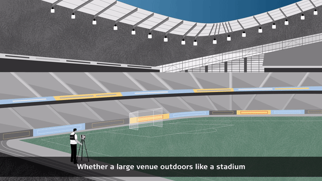
The pre-planning phase: Information intelligence and risk assessment for a major event
The security of an event is not limited to the space that you or your customer's organisation inhabit. Planning for any event follows a systematic process that simplifies what can feel very overwhelming and time consuming for many event organisers, business owners and security managers.
Whether it be a large venue outdoors like a stadium (to be captured with our 3D laser scanners or the Pegasus:Backpack) or small indoor venue (to document with either the BLK360, BLK3D, or BLK2GO), our data capture and real-world visualisation solutions offer you the needed information and threat intelligence and support you with risk assessment and management.

The operational phase: Physical protection, surveillance and preparedness for incident response
Deploying a combination of 3D intelligence from our surveillance solution and overt and covert protective security solutions keeps the public safe and the country borders protected. Security managers, customs and border patrol commands have complete information, are better prepared and can flexibly make and communicate effective decisions.
Our solutions allow you to prepare security, emergency response, customs, and border protection staff to respond to possible incidents while minimising disruption and maintaining the smooth running of the event or operation.

The post-event and analysis phase
Our laser scanning, autonomous, and mobile mapping solutions give security professionals, customs and border patrol officers access to high-quality data to effectively map the surroundings for reconnaissance and pre-planning phase as well as the secure operation of the event or mission. Based on the gathered 3D data intelligence, you can analyse the effectiveness of your operation, share your findings with your customers, stakeholders, and commands with the Leica TruView Digital Reality Viewer and adapt the training of your staff.
Discover our recommended solutions for security and incident management
Professional-grade 3D laser scanner solution for information intelligence

Capture the scene with the Leica RTC360
With the RTC360 3D laser scanner, environments can be captured at up to 2 million points per second in less than two minutes. The RTC360 is a versatile and a robust laser scanner (IP54) and is an ideal solution for outdoor or indoor areas.

Manage the data with Leica Cyclone FIELD 360 and Leica Cyclone REGISTER 360
Captured scan data is visualised and pre-registered directly in the field in real-time with the Cyclone FIELD 360 app, allowing users to perform quality control and assurance of the data.
Quickly post-process 3D environments in the office with Cyclone REGISTER 360 software.

Deliver a wide array of reports with Leica Map360
Our forensic mapping software, Map360 is the best solution for complete scene or incident visualisation and reconstruction. Flexibly import your data from a wide range of sensors. Map360 helps you to transform your 3D data into accurate and compelling 3D Digital Twin.
Handheld 3D laser scanner with LiDAR and SLAM spatial awareness technology for capturing locations and incident scenes

Capture the scene with the Leica BLK2GO
The Leica BLK2GO is a handheld imaging laser scanner that captures colorized 3D point clouds while you walk. For quick documentation of investigation scenes and other areas of interest, you can dramatically reduce the time spent scanning onsite with award-winning mobile mapping and GrandSLAM technology. Rapidly move through any scene with the BLK2GO and it will capture all dimensions, and you can capture geotagged detail images during your scan for further documentation.
Deliver a wide array of reports with Leica Map360
Our scene mapping software, Map360 is the best solution for complete scene or incident visualisation and reconstruction. Flexibly import your data from a wide range of sensors. Map360 helps you to transform your 3D data into an accurate and compelling 3D Digital Twin.
3D smart surveillance system for threat detection and protection

Smart threat detection and intrusion prevention
The BLK247 is a smart 3D surveillance system that immediately determines threats versus non-threats with accuracy and reliability. BLK247 sensor fusion technology combines LiDAR, video, and thermal imaging sensors. It monitors spaces by performing real-time change detection in 3D.

Manage the data with Accur8vision
Accur8vision is an expanded perimetric security system. Accur8vision guards the entire area of a patrolled space and is suitable for securing large and small areas.

Deliver the results/reports with Smart Surveillance System
Increase overall confidence in your security system. Monitor an entire space 360° horizontal x 270° vertical field-of-view coverage and define specific areas of interest for surveillance using 3D geofencing. Define alarm zones. Change the protective zones flexibly according to your needs. Provide security for places, where fence and infra-barriers can’t be installed. Monitor the movement of people and prevent possible intrusion.
BLK ARC brings autonomous reality capture to robotic carriers allowing for scanning of dangerous or hazardous areas

Capture the scene with the Leica BLK ARC
The Leica BLK ARC is an autonomous laser scanning module for robots and robotic carriers—and our first integration is with the Boston Dynamics Spot robot. Capture any investigation scene with minimal or no human intervention. With GrandSLAM technology, the BLK ARC scans autonomously while the robot carries it and can stop to take individual static scans. Plan a scan route remotely and set the BLK ARC off on its own to capture the data you need with no disruption to the scene.

Manage the data with Leica Cyclone FIELD 360 and Leica Cyclone REGISTER 360
Captured scan data is visualised and pre-registered directly in the field in real-time with the Cyclone FIELD 360 app, allowing users to perform quality control and assurance of the data. Quickly post-process 3D environments in the office with Cyclone REGISTER 360 software.

Deliver a wide array of reports with Leica Map360
Our forensic mapping software, Map360 is the best solution for complete scene or incident visualisation and reconstruction. Flexibly import your data from a wide range of sensors. Map360 helps you to transform your 3D data into accurate and compelling 3D Digital Twin.
Scan in 3D hard-to-reach or hazardous areas like rooftops and facades from the sky

Capture the scene with the Leica BLK2FLY
The Leica BLK2FLY is an autonomous flying laser scanner that captures digital twins from the sky. For any investigation scene, you can easily scan with the BLK2FLY from above, especially for hard-to-reach or hazardous areas like rooftops and facades. With GrandSLAM technology that incorporates advanced obstacle avoidance, the BLK2FLY requires minimal training and can simply be set to fly its course over the scene to capture all data needed.

Manage the data with Leica Cyclone FIELD 360 and Leica Cyclone REGISTER 360
Captured scan data is visualised and pre-registered directly in the field in real-time with the Cyclone FIELD 360 app, allowing users to perform quality control and assurance of the data. Quickly post-process 3D environments in the office with Cyclone REGISTER 360 software. You can also use the BLK2FLY Live app to control scan settings and take manual flight control.
Deliver a wide array of reports with Leica Map360
Our scene mapping software, Map360 is the best solution for the complete scene or incident visualisation and reconstruction. Flexibly import your data from a wide range of sensors. Map360 helps you to transform your 3D data into an accurate and compelling 3D Digital Twin.
Versatile and wearable mobile mapping solution for gathering location and information intelligence

Wearable 3D reality capturing of the environment indoor and outdoor, above and underground
The Leica Pegasus:Backpack is a disruptive wearable system enabling to capture realities faster, spending less time in the field and enabling to make quick and informed decisions in fast-changing, challenging and hostile environments. Use the point clouds and imagery to produce centimetre-accurate 3D models and maps of streets and buildings; floor plans and elevation models; 2D and 3D data of existing evacuation/egress routes, and more. These deliverables can be used to analyse existing above and underground emergency evacuation procedures and scenarios or for optimal surveillance and support team placement.
Contact our Public Safety, Security and Forensics experts

Advanced security work: Anticipate, plan, prepare with the Leica BLK3D Imager
Read how the BLK3D helps security professionals gather, correct and complete reconnaissance and threat plan with data, pictures, and measurements of any venue, easily identify vulnerable points, and more.
Read how the BLK3D helps security professionals gather, correct and complete reconnaissance and threat plan with data, pictures, and measurements of any venue, easily identify vulnerable points, and more.

Capturing reality in one of the world’s busiest airports
Changi Airport Group used the latest laser scanning technology to maintain one of the world’s busiest airports to the highest standards in the long term without disrupting the constant flow of passengers.
Changi Airport Group used the latest laser scanning technology to maintain one of the world’s busiest airports to the highest standards in the long term without disrupting the constant flow of passengers.

Redefining security and surveillance through sensor fusion
Listen how the BLK247, a smart surveillance system that combines the power of LiDAR, video, and thermal imaging, can autonomously detect and report physical changes within a space.
Listen how the BLK247, a smart surveillance system that combines the power of LiDAR, video, and thermal imaging, can autonomously detect and report physical changes within a space.

Why choose us
Peer-to-peer advice, consultancy and practical assistance. We are a partner trusted by public and private sector organisations, offering the broadest portfolio of geospatial tools, reliable service, and expertise.
Peer-to-peer advice, consultancy and practical assistance. We are a partner trusted by public and private sector organisations, offering the broadest portfolio of geospatial tools, reliable service, and expertise.

Applications
Our know-how serves Public Safety professionals worldwide and redefines the way law enforcement personnel manage incident and scene investigation, evidence gathering, and forensic mapping.
Our know-how serves Public Safety professionals worldwide and redefines the way law enforcement personnel manage incident and scene investigation, evidence gathering, and forensic mapping.

Solutions
Our solutions for reality capture, scene investigation or reconstruction, precise positioning and location intelligence give you the edge in creating your Forensic Digital Twin.
Our solutions for reality capture, scene investigation or reconstruction, precise positioning and location intelligence give you the edge in creating your Forensic Digital Twin.

Learning centre
Whether looking to move beyond traditional documentation methods or master your technology, our training resources support you in every step of your day-to-day job.
Whether looking to move beyond traditional documentation methods or master your technology, our training resources support you in every step of your day-to-day job.