


Q&A on Visual Positioning and Leica GS18 I

Product Engineer Metka Majeric answers questions on Visual Positioning technology and the Leica GS18 I GNSS RTK Rover.
What are the challenges when surveying with a conventional GNSS sensor?
To be able to measure points, a GNSS sensor needs to receive satellite signals. The position of a point can only be measured when the GNSS RTK sensor has access to the open sky and the pole tip is physically in reach of the point. If this is not possible surveyors can use alternatives methods such as:
- Different workarounds e.g. taping offset, using COGO functionality and sketching
- Additional equipment in combination with the GNSS RTK sensor e.g. CS20 with integrated DISTO or a 4 metre pole. This way of measuring can be time-consuming and may also compromise the accuracy.
- Alternative sensors like total stations. Using such alternatives can also be time-consuming, when there are only a few points that cannot be measured with a GS sensor.
Users face an additional challenge, when a lot of detail needs surveying. Measuring every single point with the pole tip requires a lot of time on site. There is also a risk that some points are missed, and the site needs to be revisited resulting in additional costs.
How does the Leica GS18 I overcome those challenges?
With the GS18 I there is no need to use other time-consuming methods or additional equipment. Due to the integration of GNSS, IMU (Inertial Measurement Unit) and a camera, the points with obstructed view to the sky and other inaccessible points can be measured from images using the Visual Positioning technology within GS18 I. This new technology allows points of interest captured from a distance to be measured with survey-grade accuracy.
In which situations would surveying professionals use Visual Positioning technology?
Visual Positioning is particularly appropriate for:
- Mapping hundreds of points.
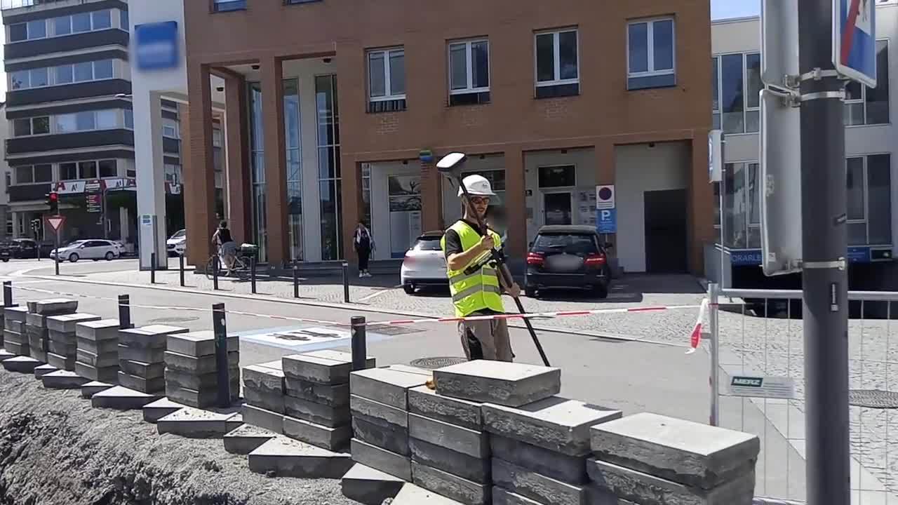
- Measuring inaccessible points such as across a busy street, behind a gate or in dangerous areas (e.g. with the risk of being attacked by a dog, hazardous utilities, on a roof edge).
Figure 1 - Leica GS18 I GNSS RTK rover while measuring points over a fence

- Surveying points in places with GNSS signal obstruction (e.g. under a roof, balcony or tree).
- Measuring points on the façade of a building (e.g. corners of a window and height of the roof).
Figure 2 - Measuring façades

- Measuring additional points without the need to revisit the site.
- Generating point clouds of captured objects.
Figure 3 - Point cloud generated from image groups captured with GS18 I

- Volume calculation of stockpiles.
- Capturing images of a crash scene for point measurements.
Figure 4 - Capturing a crash scene

Who should use a GS18 I?
GS18 I is designed for users who need to easily measure points that are challenging to reach with a conventional GNSS RTK rover. The GS18 I is the ideal tool for users to collect large amounts of data onsite. Users can decide later, which points to measure in images survey-grade accuracy.
How does the GS18 I work? (Measurement principle)
Let’s take the following video as an example.
A user wants to measure some points of interest in the trench. All that needs to be done is to walk along the trench with the camera pointed towards the pipeline while the GS18 I automatically captures images. The GS18 I captures images at the rate of 2 Hz ensuring the optimal image overlap and geometry. Once the capturing is stopped, the images will be automatically processed by the algorithms running on Captivate. The images can be used for point measurement right after the captured images are processed.
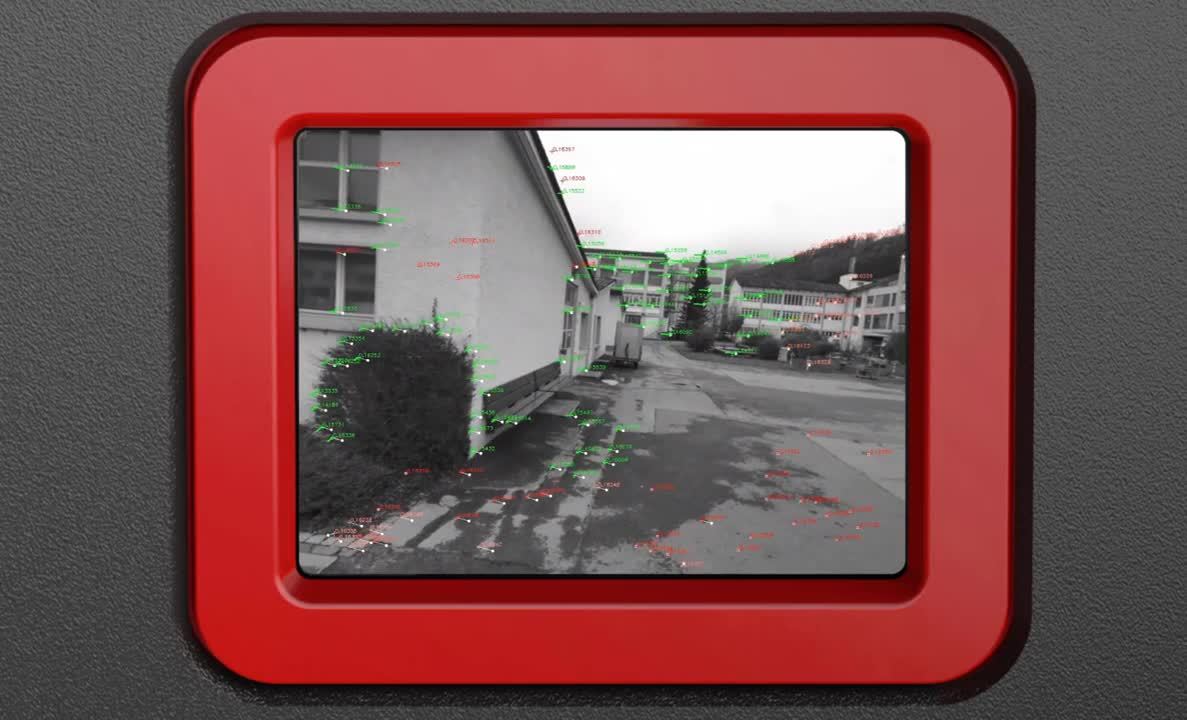
During capture, GS18 I checks whether the position and tilt quality are sufficiently accurate. If not, the capturing is automatically stopped, but the images that were already captured are processed. In addition, GS18 I establishes a geometric connection between consecutive images by extracting features (distinctive points) from images.
The following video shows how the algorithm running on the GS18 I tracks the features during capture:
The images can be used for point measurement immediately after. This is made possible by the Visual Positioning technology.
Which software is needed to process captured images?
GS18 I is fully supported by Captivate software running on the CS20 LTE or BASIC controller or the CS35 tablet.
Captivate will automatically process, position and orientate the captured images, therefore ensuring quality control already on site. There is no need to match any reference points or lines manually, as required when using similar technologies.
How can points be measured in images and which software is needed?
Points are measured from images within Captivate running on the CS20 LTE or BASIC controller or the CS35 tablet. Users can measure points in the field right after the images are captured.
Images can also be imported into Infinity, where users can measure points in the office on a large screen.
Simply pick one point in an image and the algorithm will automatically match the same point in the other images. With one click the 3D coordinates of the measured point will be calculated and stored within Captivate, just as they would have been with the pole tip.
When using other solutions to calculate 3D coordinates from images, points have to be manually picked from each image. With the GS18 I points don’t need to be manually picked in each image as the algorithm does this work for you. When the picked point is matched in consecutive images, the 3D position of the point is reconstructed by means of forward intersection, as shown in the image below.
Figure 5 -Forward intersection

What is the fundamental principle behind Visual Positioning technology?
Visual Positioning technology is based on the information provided by the GNSS positions, the IMU and the captured images.

Figure 6 - Sensor fusion
Let’s take the following video as an example of a measurement principle.
To measure points with a GS18 I, go to the start position and begin capturing images in Captivate. Now walk along, holding the GS18 I with its camera facing the corner. Images will be automatically captured with a frequency of 2 Hz. After the capturing is stopped, Captivate automatically computes the position and the orientation of the images in a global coordinate system, by integrating the data from the GNSS and the IMU with features recognised in the images. These images are then saved as an image group within Captivate.
Images are processed in real-time and can be used for measuring points right after capture stops. Using only one image, a point can be measured with a single click. The algorithm running on Captivate will automatically match the picked point in other images and calculate the coordinates of the point in a local coordinate system by means of a forward intersection.
Is it also possible to create point clouds from captured images?
Yes, images captured with the GS18 I can also be used in Infinity office software to generate 3D point clouds.
How does the GS18 I differ from GS18 T?
The GS18 I is the new flagship product of Leica Geosystems' portfolio of GS sensors. It has all the functionality of the GS18 T with the added value of Visual Positioning technology.
Just like any other GS sensor, the GS18 I can use RTK corrections from all GNSS correction services. For optimal measurement performance with the GS18 I, we recommend using HxGN SmartNet, a GNSS correction service, that can be used with any GNSS device, and is constantly monitored for integrity, availability and accuracy.
Why should I invest in the Leica GS18 I?
Here's why the GS18 I can be of benefit for users:
- The GS18 I is a versatile GNSS RTK sensor. It can be used to measure points with a levelled or tilted pole. In addition, it can be used to measure inaccessible points with survey grade accuracy by capturing and measuring from images.
- Inaccessible points can be easily captured in images without compromising safety.There is no need to worry about how to measure points across a busy street or on a property with a dangerous dog.
- Reduce field time by capturing the scene efficiently and decide later, what should be measured. This increases productivity because you can measure the points from images in the field or the office and you don't need to return to the site to measure new points.
What should a user consider when using the GS18 I?
Visual Positioning technology is based on the GNSS and IMU measurements as well as the images captured with the integrated camera. There are some conditions that should be considered, when using the GS18 I for measuring from images:
- GS18 I needs to have sufficient reception of GNSS signals for the duration of the measurement. If tracking of the GNSS satellites is lost, the capture will automatically stop.
- If Visual Positioning is required, avoid using it in dark conditions or when directly facing the sun, because enough features in the captured images will not be easily recognised to match them.
-
For optimal accuracy and performance, capture the object of interest from a distance between 2m and 10m.
When the images are captured from the distance lower than 2 m, the images can be blurred due to the fixed focus of the camera. On the other hand, when the images are captured from the distance bigger than 10 m, the accuracy decreases.
-
It is possible to capture images from a distance less than 2 m or greater than 10 m from the object. In such cases, the user has to take into consideration, that the accuracy may be reduced. There is also a risk that measuring points using images will not be possible.
- Image capture speed is optimised for normal walking speed. It is not possible to use the GS18 I mounted on a moving vehicle because the images might be blurred.

Metka Majeric
Product Engineer
Leica Geosystems
To learn more about the Leica GS18 I, please visit: leica-geosystems.com/GS18I


Pelatihan Online
Leica Geosystems telah mengembangkan platform pelatihan online dengan tujuan mengedukasi pelanggan lebih lanjut dalam memaksimalkan fungsi instrumen.
Leica Geosystems telah mengembangkan platform pelatihan online dengan tujuan mengedukasi pelanggan lebih lanjut dalam memaksimalkan fungsi instrumen.

Contact our Public Safety, Security and Forensics experts
Peer-to-peer advice from experienced Public Safety experts
Peer-to-peer advice from experienced Public Safety experts