


Map360 Scene Mapping and Reconstruction Software - Sketch

CREATE ACCURATE DIAGRAMS IN MINUTES WITH MINIMAL EQUIPMENT
Map360 Sketch is the perfect entry-level scene documentation, reconstruction, and diagramming software. Sketch is the ideal solution to create incident scene diagrams, pre-incident plans, and other courtroom exhibits that are compelling and easy to understand. Map360 Sketch is easy to use, quick to learn, and budget-friendly.
Map360 Sketch provides 2D drawing and viewing only. Users can import points, drone/UAV images, Ortho Slices, Bing Maps, or use manual measurements to create basic diagrams and deliverables. All 2D drawing and editing tools are available, but there are no analysis tools included with Map360 Sketch.
Contact our Public Safety, Security and Forensics experts

Map360 Sketch - Impressive 2D digital scene diagramming using just a notepad, tape measure and smartphone.
In law enforcement, police officers, crash and crime reconstructionists and fire investigators often need to document critical incidents quickly, easily, but accurately in less-than-ideal circumstances. Time is of the essence. Preservation of the scene by trained personnel and with the right equipment is crucial.
Documenting the scene with Leica’s Reality Capture solutions and showcasing and explaining the possible course of events in a simple but accurate way is now possible with the Leica Map360 Sketch solution. With Sketch, investigators can quickly create an accurate 2D digital scene diagram using basic tools.
In this video, one of our Public Safety experts will walk you through a mock accident scenario and explain how to create an accurate digital scene diagram in just 10 minutes using Map360 Sketch, a notepad, a tape measure, and a smartphone.
Fast and Accurate Digital 2D Scene Mapping
Manual measurements
Map360 Sketch is the ideal solution for creating diagrams, pre-incident plans, and other courtroom exhibits that are compelling and easy to understand. Map360 Sketch is easy to use, quick to learn, and budget-friendly, a perfect entry-level reconstruction and diagramming software!
In this software package, only 2D drawing and viewing are included. Users can import points, UAV images, an Ortho Slice, Bing Maps, or use manual measurements to create basic diagrams and deliverables. All 2D drawing and editing tools are available, but there are no analysis tools included with Map360 Sketch.
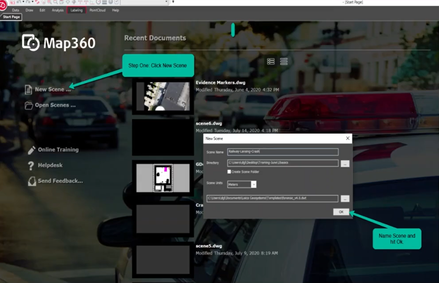
Step 1
Learn how to use an aerial image from Google or Bing, scale and create an image layer in Map360 Sketch.
Step 2
Learn how to "translate" your measurements from the scene implementing them in the diagram with our Baseline/Offset tool.
Step 3
Learn how to add 2D symbols to your drawing (bikes, cars, etc). Add evidence markers and attach additional pictures of evidence.
Step 4
Learn how to create and publish a PDF of your drawing and publish the final evidence report.
Working with drones/UAV
As drones become more popular for capturing of outdoor crime, crash or fire scenes, Map360 Sketch supports the work with geo.tifs data created in Pix4D Mapper or Leica Infinity.
It’s as simple as adding an attachment to an email. You attach the image and the corresponding world file to its own layer in Map360 Sketch. This allows you to bring in scaled images with the correct orientation. There is no need to scale images manually, which minimises human errors. Using GPS data while collecting your points directly on the scene allows for accurate positioning on top of the image.
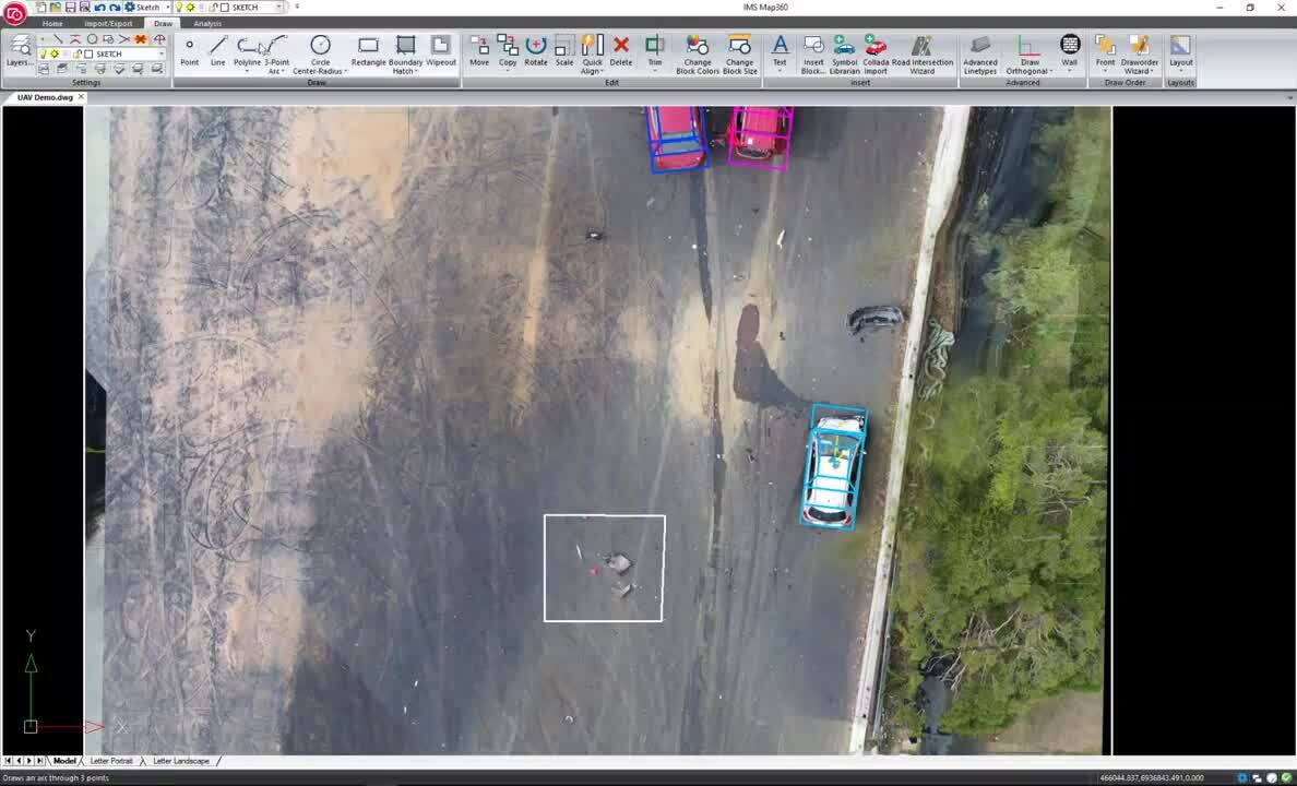
Step 1
Import the orthorectified image with its corresponding world file.
Step 2
Insert vehicles from the Canadian Vehicle Specs Database
Step 3
Trace fluid path and debris and add hatching.
Step 4
Add dimensions, leaders, labels, and a scale bar.
Step 5
Insert evidence markers and legend.
Step 6
Export diagram and create evidence report.
2D scaled diagram from a point cloud ortho-slice
Using a laser scanner allows investigators to quickly capture and “freeze” every detail of any incident scene in the form of accurate, measurable 3D point clouds, ensuring complete transparency and being an irrefutable source of truth. Point cloud data can be used as the basis for various compelling, immersive exhibits. But often, investigators need to start with 2D scaled diagrams. What’s the fastest, easiest way to deliver these drawings?
Quickly and easily create an orthoimage slice from the scan data and use the slice in Map360, Leica’s forensic scene diagramming software, to create a 2D diagram. Different layers can be used and turned on and off to show labels, evidence, measurements, and other details as needed.
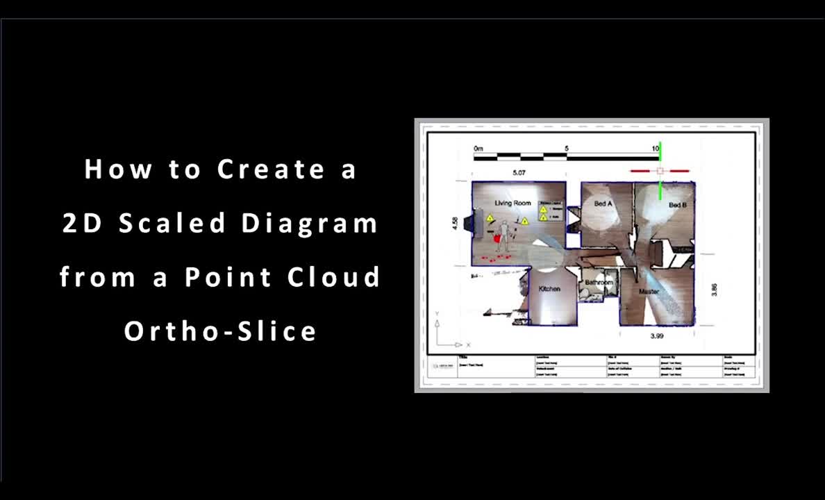
Step 1
Bring your point cloud data collected directly at the crash, crime or fire scene into Leica Cyclone REGISTER 360 software.
Step 2
Create the commonly used 2D scale diagram by generating an orthoimage from the slicing of the point cloud.
Step 3
Easily import your ortho slice into Map360 Sketch with only a couple of quick commands.
Step 4
Analyze and diagram your ortho slice.
Step 5
Create a scale deliverable with one of our template to share with others
Contact our Public Safety, Security and Forensics experts

LEARN IT - Online school
Learn the first steps of Map360 Sketch by participating in a self-led on-demand online environment.
Learn the first steps of Map360 Sketch by participating in a self-led on-demand online environment.

TRY IT - Demo download
Test drive Map360 Sketch with a fully functional 30-day copy. See for yourself if it’s the right fit.
Test drive Map360 Sketch with a fully functional 30-day copy. See for yourself if it’s the right fit.

BUY IT - Online Store
Looking for a copy of Map360 Sketch? Purchase online in our secure environment.
Looking for a copy of Map360 Sketch? Purchase online in our secure environment.

Why choose us
Peer-to-peer advice, consultancy and practical assistance. We are a partner trusted by public and private sector organisations, offering the broadest portfolio of geospatial tools, reliable service, and expertise.
Peer-to-peer advice, consultancy and practical assistance. We are a partner trusted by public and private sector organisations, offering the broadest portfolio of...

Applications
Our know-how serves Public Safety professionals worldwide and redefines the way law enforcement personnel manage incident and scene investigation, evidence gathering, and forensic mapping.
Our know-how serves Public Safety professionals worldwide and redefines the way law enforcement personnel manage incident and scene investigation, evidence gathering, and...

Solutions
Our solutions for reality capture, scene investigation or reconstruction, precise positioning and location intelligence give you the edge in creating your Forensic Digital Twin.
Our solutions for reality capture, scene investigation or reconstruction, precise positioning and location intelligence give you the edge in creating your Forensic Digital...

Learning centre
Whether looking to move beyond traditional documentation methods or master your technology, our training resources support you in every step of your day-to-day job.
Whether looking to move beyond traditional documentation methods or master your technology, our training resources support you in every step of your day-to-day job.