


Roads & Highways
Let us help you deliver your next road and highway project on time, safely and as efficiently as possible.
Deliver the most accurate and complete geospatial data for roads & highways
Engineering surveyors can help the planning, designing and building roads & highway projects as safely and efficiently as possible with Leica Geosystems solutions.
Our complete portfolio of surveying solutions, machine control systems and construction positioning solutions ensure safety, help you be faster, collaborate in the cloud, digitalise workflows and deliver the most accurate geospatial data in every phase of the construction lifecycle of highways and roads.
Discover the solutions at each phase of the construction life cycle and let our solutions increase your efficiency.
Construction lifecycle phases

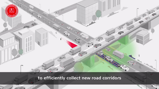
Design & Capture
Start projects the right way with the most accurate models. Determine site conditions for new and existing highways and roads and ensure safe excavation through mapping buried utilities.
Start projects the right way with the most accurate models. Determine site conditions for new and existing highways and roads and ensure safe excavation through mapping buried utilities.

Construct & Build
Optimise your design-to-field workflow to be complete and seamless with minimum delays. Our solutions are compliant with the latest BIM/IFC standards, enabling proper integration of the design into the as-built process.
Optimise your design-to-field workflow to be complete and seamless with minimum delays. Our solutions are compliant with the latest BIM/IFC standards, enabling proper integration of the design into the as-built process.

Operate & Maintain
Optimise maintenance using the best-in-class monitoring and reality capture solutions with the highest resolutions and fastest collection and update rates. All of this is supported by a world-class suite of data management software.
Optimise maintenance using the best-in-class monitoring and reality capture solutions with the highest resolutions and fastest collection and update rates. All of this is supported by a world-class suite of data management software.
In your own words

Keeping staff safe
“I’m often working near live traffic, and now I can be a step farther away just by leaning the pole out and taking the shot without plumbing up. The increased speed is great, of course, but working more safely is probably the biggest advantage.”

LiDAR data for topographic survey
“Just the amount of time you’d use on small sites picking everything up—to go from that to collecting a mile of roadway data and the underside of a bridge in less than three hours total field time is just staggering.”

Scans, spans and automobiles
“The use of the BLK360 technology helped remove surveyors from harm's way on a number of risky jobs, including the DBFO2 work on the motorway.”

The faster road to mobile data capture
“We’ve already seen an increase in mobile mapping projects on the east coast of Australia and our clients are happy with the highly detailed data and impressive imagery. A key client in Melbourne was amazed at the turnaround time.”

First company to invest in the Leica Pegasus TRK500
“With the Leica Pegasus TRK, we can offer more information, and better information, early on in projects where we can eliminate some of the unknowns that happen during preliminary and final design.”

Soluciones topográficas
Independientemente de lo compleja que sea su tarea, existe una solución disponible dentro de nuestra cartera de productos de medición, posicionamiento, visualización y colaboración para ayudarle a tener éxito y ser más eficiente.
Independientemente de lo compleja que sea su tarea, existe una solución disponible dentro de nuestra cartera de productos de medición, posicionamiento, visualización y colaboración para ayudarle a tener éxito y ser más eficiente.

Haga crecer su negocio
Descubra cómo adoptando la digitalización y la tecnología puede ayudar a su empresa a crear nuevas oportunidades, a ser competitivo y a mejorar su productividad.
Descubra cómo adoptando la digitalización y la tecnología puede ayudar a su empresa a crear nuevas oportunidades, a ser competitivo y a mejorar su productividad.
Surveying Solutions
Regardless of how complex your task is, a solution is available within our diverse measuring, positioning, visualising and collaborating portfolio to help you succeed and be more efficient.
Regardless of how complex your task is, a solution is available within our diverse measuring, positioning, visualising and collaborating portfolio to help you succeed and be more efficient.

Mejore sus habilidades
Adquiera habilidades para ser más eficiente y reaccionar ante las oportunidades de negocio. Incremente su potencial para ofrecer a sus clientes servicios de más calidad, más especializados y más rápidos.
Adquiera habilidades para ser más eficiente y reaccionar ante las oportunidades de negocio. Incremente su potencial para ofrecer a sus clientes servicios de más calidad, más especializados y más rápidos.