


Map360 Scene Mapping and Reconstruction Software - Pro

Leica Map360 Pro is an advanced, professional visualisation and animation software which completely transforms courtroom presentations. Map360 Pro offers the import of point cloud data to create fully immersive 3D environments that leave police officers, crash investigators, fire reconstructionists, jurors and judges with the sense of being at the respective incident scene.
Map360 Pro is the most robust scene diagramming software which utilises 3D point cloud data for bloodstain pattern analysis (BPA), bullet trajectory analysis, witness views, advanced diagramming, and immersive animations.
Contact our Public Safety, Security and Forensics experts

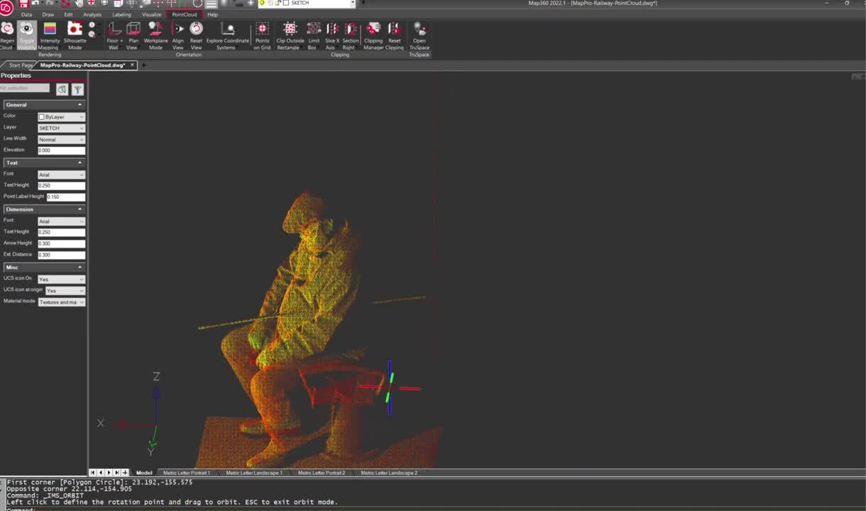
Examine witness views and gain perspective in a 3D point cloud
With Map360 Pro, investigators transform all data collected at the scene into accurate and reliable information: the Forensic Digital Twin, an accurately, holistically harvested 3D digital replica of a real-life scene, including all critical evidence in 3D.
Map360 Pro provides the same capabilities as the Map360 Standard edition but also includes a robust point cloud engine powered by Leica Geosystems’ Cyclone software. Fluid navigation in 2D and 3D allows the scanned crime, accident, or fire scene to be viewed from any angle in the Forensic Digital Twin.
Digitise and create 3D diagrams and visuals of the scene, complete with Geotags. Use the scanner’s panoramic imagery to position yourself in the point cloud to get the optimal view. Map360 Pro utilises the point cloud data for bloodstain pattern analysis, bullet trajectory analysis, witness views and advanced diagramming and animations.
Map360 Pro - 3D Point Clouds for BPA, Bullet Trajectory, Witness Views, and Animations
Reconstruct bullet path trajectory from a scanned crime scene
Reconstruct bullet path trajectory from scanned trajectory rods in the scene. Determine the horizontal and vertical angles and extend the error cone while maintaining the set tolerance. The trajectory cones provide a 3D visual representation derived from the evidence at the scene. Export the trajectory cones as COE to be viewable in TruView, providing an interactive 3D deliverable.
Step 1
Review the 3D point cloud data in the Forensic Digital Twin.
Step 2
Limit the view for easier visualization.
Step 3
Edit settings for the bullet path reconstruction.
Step 4
Review the bullet angle in the 3D point cloud.
Step 5
Export your crime scene 3D project to COE for easy sharing.
Locate the blood spatter origin with bloodstain pattern analysis
Map360 Pro includes the Bloodstain Pattern Analysis (BPA) feature that allows investigators to analyse impact patterns, define the area of origin, and produce 2D or 3D immersive visuals of the crime scene. This directional analysis of bloodstain patterns provides critical information to assist analysts in locating the source of the blood (the origin) at a crime scene. The intuitive BPA Ribbon walks you through each step in the workflow.


Step 1
Choose the desired coordinate system.
Step 2
Choose an existing surface that was just defined to align with the view.
Step 3
Draw stains on the photo easily and accurately.
Step 4
Add the different stains to define the area of origin with the convergence sphere.
Step 5
Generate a comprehensive report showcasing and visualising the results from your analysis.
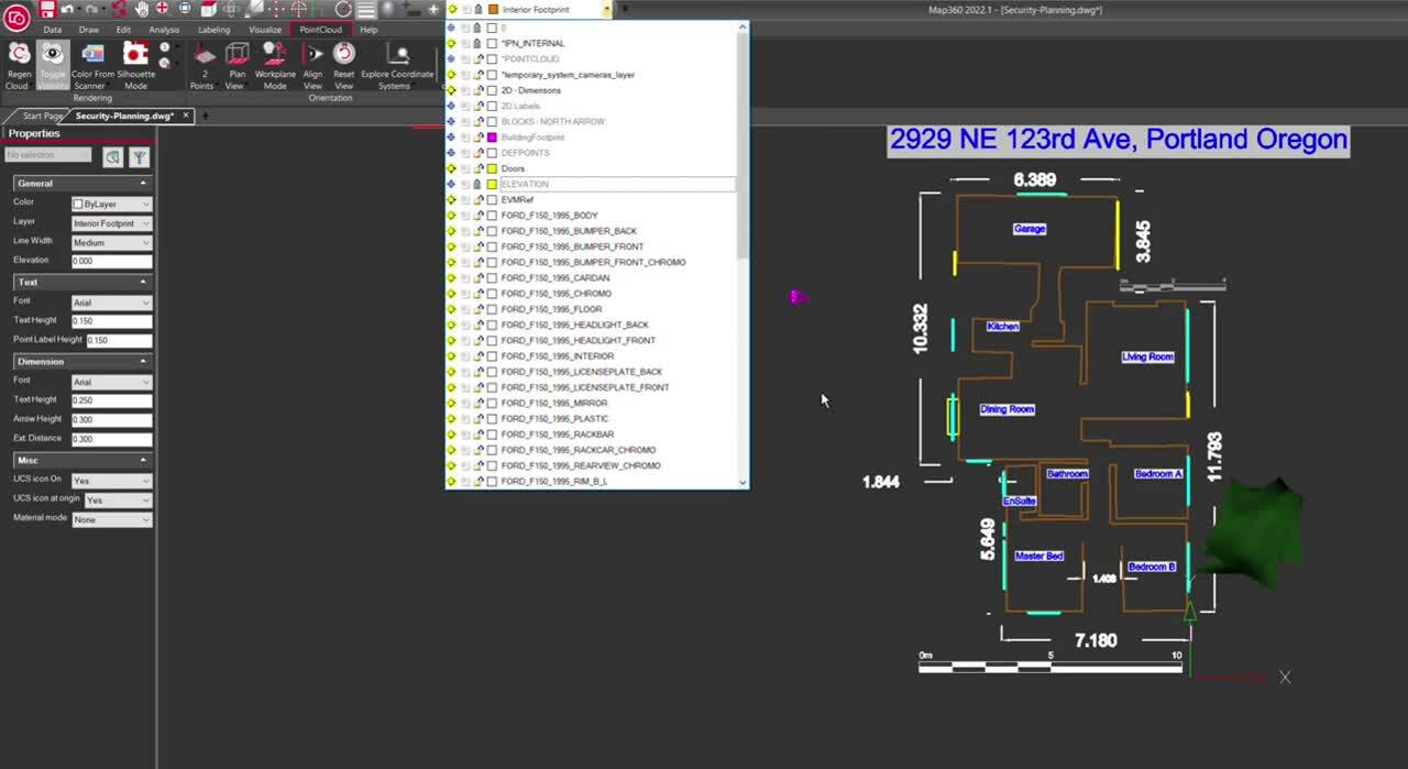
Pre-planning, executing a search or doing surveillance work?
Supporting your pre-planning activities, Map360 Pro turns your 3D point clouds into actionable security-relevant information to support your mission. Use the point cloud data of the scanned site or environment to create a 2D map or 3D diagram to see all the possible entrances and exits in your location. Label and highlight possible escape routes or use them to position and lead your security team effectively. Combine your aerial images of the target from, e. g. the Drone Unit, with the Forensic Digital Twin for your reference and more accurate pre-plans.

Step 1
2D drawing from the point cloud.
Step 2
Change perspective and view the site's possible vulnerabilities.
Step 3
Turn on 3D point cloud data for realistic and immersive views.
Step 4
Import aerial or other reference images of the target or location in the Digital Twin for more accurate pre-plans.
Contact our Public Safety, Security and Forensics experts

LEARN IT - Online school
Learn the first steps of Map360 Standard by participating in a self-led on-demand online environment.
Learn the first steps of Map360 Standard by participating in a self-led on-demand online environment.

TRY IT - Demo download
Test drive Map360 Standard with a fully functional 30 day copy. See for yourself if it’s the right fit.
Test drive Map360 Standard with a fully functional 30 day copy. See for yourself if it’s the right fit.

BUY IT - Online Store
Looking for a copy of Map360 Standard? Purchase online in our secure environment.
Looking for a copy of Map360 Standard? Purchase online in our secure environment.

Mengapa memilih kami
Saran, konsultasi, dan bantuan praktis peer-to-peer. Kami adalah mitra yang dipercaya oleh organisasi sektor publik dan swasta, yang menawarkan portofolio alat bantu geospasial yang paling beragam, layanan yang andal, dan keahlian.
Saran, konsultasi, dan bantuan praktis peer-to-peer. Kami adalah mitra yang dipercaya oleh organisasi sektor publik dan swasta, yang menawarkan portofolio alat bantu...

Aplikasi
Pengetahuan yang kami miliki membantu para profesional Keselamatan Publik di seluruh dunia dan mendefinisikan ulang cara yang digunakan penegak hukum dalam mengelola penyelidikan insiden dan tempat kejadian perkara, pengumpulan bukti, dan pemetaan forensik.
Pengetahuan yang kami miliki membantu para profesional Keselamatan Publik di seluruh dunia dan mendefinisikan ulang cara yang digunakan penegak hukum dalam mengelola...

Solusi
Solusi kami untuk reality capture, penyelidikan atau rekonstruksi tempat kejadian perkara, pemosisian akurat, dan intelijen lokasi memberi Anda keunggulan dalam menciptakan Digital Twin Forensik.
Solusi kami untuk reality capture, penyelidikan atau rekonstruksi tempat kejadian perkara, pemosisian akurat, dan intelijen lokasi memberi Anda keunggulan dalam menciptakan...

Pusat pembelajaran
Entah Anda ingin beralih dari metode dokumentasi tradisional atau ingin menguasai teknologi, sumber daya pelatihan kami siap mendukung setiap langkah pekerjaan Anda sehari-hari.
Entah Anda ingin beralih dari metode dokumentasi tradisional atau ingin menguasai teknologi, sumber daya pelatihan kami siap mendukung setiap langkah pekerjaan Anda...