As urban environments grow denser and civil infrastructure ages, managing buried utilities has become just as important as mapping what sits at the surface. Transport authorities, municipalities, and engineering firms are moving away from fragmented, single-asset surveys in favour of complete 3D digital twins that capture surface and subsurface assets together.
However, running separate surface surveying and subsurface utility engineering (SUE) workflows doubles exposure to live traffic, increases operational costs, and frequently produces misalignment between surface features (like manholes, valves, kerbs) and the pipes, cables, and ducts that lie beneath them.
The alternative is an integrated, non-intrusive approach. By combining a mobile mapping system like the Leica Pegasus TRK with a vehicle-mounted ground-penetrating radar (GPR) system like the IDS GeoRadar Stream UP, survey teams can capture high-density 3D point clouds, 360° imagery, and subsurface utility networks simultaneously in a single drive at normal traffic speeds. This unified workflow eliminates operational silos, protects field crews, and delivers a complete, survey-grade 3D model above and below the ground.
Synchronised above- and below-ground workflow
Combining mobile mapping with GPR follows an integrated workflow designed to maximise coverage while maintaining survey-grade accuracy and positioning.
Setting up the system
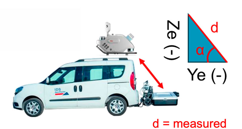
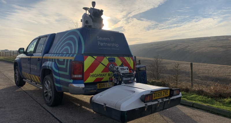
The Pegasus TRK unit is mounted to the rear roof or roof rack of the vehicle, while the Stream UP attaches directly to the vehicle’s rear tow bar, hovering just above the road surface without touching the ground. A single cable connects the Stream UP to the Pegasus TRK’s external sync port.
Before the drive, operators perform a spatial lever arm calculation to define the precise 3D distance offset (Dx, Dy, Dz) between the reference point on the Pegasus TRK (VLP rear) and the Stream UP antenna. Because the TRK serves as the core positioning engine for the Stream UP GPR, this offset ensures underground radar data is mapped to the exact same spatial coordinates as the surface point cloud. If the lever arm calculation is incorrect, underground features will be spatially shifted out of position.
Dry road conditions without rain or snow are optimal for GPR data collection.
Capture all data in a single drive
Traditional GPR systems rely on orthogonal scanning. A cart is pushed back and forth along the X and Y axes to detect pipes running parallel and perpendicular to the road.
The Stream UP instead uses a multi-frequency, multi-channel, dual-polarised antenna array, enabling it to capture longitudinal and transversal pipes simultaneously. Because of its dual-polarisation, the Stream UP does the equivalent work of traditional GPR in a quarter of the time.
However, whereas the Pegasus TRK fires LiDAR out in all directions, the Stream UP only surveys directly down. So, this requires a slightly different driving style to a normal mobile mapping survey.
To cover the whole road surface, drivers need to make parallel passes down each driving lane to cover the full width of the corridor, as though they are “brushing” the road. Data collection is typically performed at recommended speeds up to 60 km/h (37 mph), eliminating the need for lane closures or traffic stoppages.
Vehicle-mounted GPR maps in parallel lane swaths to capture complete 3D subsurface data without lane closures.
The two separate systems then feed into two separate software controllers in the vehicle cab. The Pegasus TRK imaging and LiDAR data feeds into Leica Pegasus FIELD on a tablet or laptop controller, while the Stream UP GPR data feeds into uMap running on a separate tablet or laptop. Both Pegasus FIELD and uMap display real-time coverage indicators of LiDAR and GPR data respectively, enabling users to spot any gaps in the data and rescan areas while still out in the field (so long as there is a good GNSS signal).
Combining the two datasets
Overcoming GNSS-denied environments
Standalone mobile GPR systems often struggle in urban environments. Narrow alleys, high-rise buildings, and tree-lined avenues block GNSS satellite signals, causing severe trajectory drift and rendering subsurface radar data spatially unreliable
The integrated Pegasus TRK and Stream UP solution solves this through multi-sensor trajectory fusion:
- IMU bridging: The Pegasus TRK’s Inertial Measurement Unit (IMU) continuously tracks vehicle orientation and motion when there’s no satellite signal.
- Post-processed kinematic (PPK): In Pegasus OFFICE, multi-pass trajectory optimisation corrects for IMU drift, delivering a smoothed, highly accurate trajectory line (accurate to 2-5 cm).
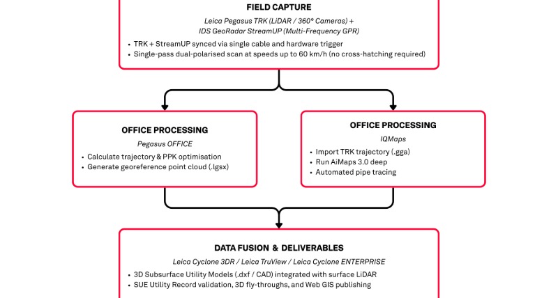
- Shared subsurface georeferencing: The optimised trajectory file (.gga) is exported directly into IQMaps software to georeference the underground GPR data.
- DMI / Odometer integration: In dense urban environments, with limited access to open sky due to tall buildings or long tunnels, it’s advised to mount a Distance Measurement Instrument (DMI) to constrain IMU drift during times of poor GNSS visibility.
Because both systems share the exact same spatial trajectory, underground radar data aligns directly with the surface LiDAR point cloud, with no manual warping or realignment required.
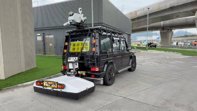
One project in Hong Kong deployed a wheel-mounted DMI to maintain precise positioning in the city’s dense urban landscape and tall skyscrapers
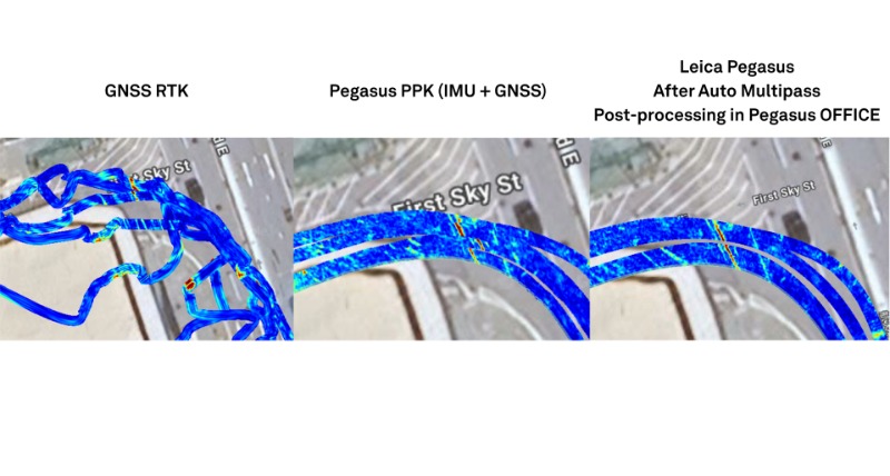
GNSS RTK alone produces poor trajectory data (left). Pegasus PPK calculation combines data from different sensors during data capture, requiring at least one GNSS reference station (centre). After a PPK calculation, a cloud-to-cloud adjustment can be processed in any multipass areas (right).
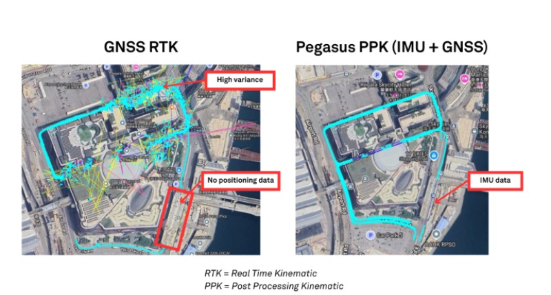
Trajectory comparison in a dense urban environment showing that standard GNSS RTK suffers from high signal variance and total data dropouts (left), whereas Pegasus PPK uses GNSS and IMU sensor fusion to maintain a continuous, survey-grade trajectory (right).
Core deliverables: above and below the surface
By capturing underground utilities alongside 3D surface infrastructure, survey teams can produce comprehensive digital twins and SUE-compliant deliverables from a single drive.
Automated pipe tracing
Processing raw GPR radar tomographies historically required specialised experts to manually interpret radar data frame by frame.
AiMaps is a cloud-based AI SaaS solution that introduces deep learning algorithms directly into the IQMaps workflow. It automatically analyses raw radar data, filters background noise, and produces clean tomography with automated pipe traces, reducing manual interpretation workload by up to 50% on complex, large-scale projects. Pipe geometries and depth profiles are extracted automatically, and because processing runs in the background on Hexagon GeoCloud, surveyors can continue other office work while the data is being handled.
SUE quality level validation and legacy record comparison
Legacy utility records are frequently wrong as ownership changes hands and changes get made without updating the drawings. Old and inaccurate records dramatically increase the risk of unsafe utility strikes, causing project delays and budget overruns.
The digitised utility model from AiMaps/IQMaps (.dxf) and the Pegasus TRK surface point cloud (.lgsx) are then imported directly into Leica Cyclone 3DR, where the radar findings sit alongside the existing utility records for direct comparison.
New, unrecorded pipes then become visible and wrong pipe depths show as discrepancies. Proposed construction and civil works can then be checked for spatial clashes against the real utility network before a potential incident, avoiding delays and additional costs downstream.
Subsurface void detection and water leakage
Combining high-density surface LiDAR with subterranean GPR provides a powerful tool for detecting underground voids before they cause dangerous and costly road collapses or sinkholes.If the surface point cloud reveals subtle pavement settlement or rutting, engineers can immediately inspect the corresponding GPR data to determine if an underlying void or leaking utility pipe is causing the subsidence.
When GPR data flags a suspected underground void, operators can analyse the precise surface profile for early relative settlement. Smaller subsurface voids can be identified in the GPR data well before visible surface deformation occurs, giving asset owners an early warning to perform preventative maintenance.
Integrated 3D digital twins
The final fused dataset combining above-ground LiDAR, 360° panoramic imagery, and subterranean 3D pipe vectors can be published directly to a shareable 3D visualisation tool, like
Leica Cyclone ENTERPRISE or
Leica TruView. This provides municipal clients, asset managers, and civil contractors with an interactive 3D model where stakeholders can virtually inspect surface features, measure pipe depths, and plan excavation work remotely. Greater visibility across the project means fewer decisions get made on the day under time pressure, which is typically when mistakes happen.
The data can also then be exported to standard third-party CAD and GIS tools for downstream engineering design and analysis such as BricsCAD, AutoCAD , or Bentley.
Expanding service offerings with mobile mapping systems
UK-based surveyors, Severn Partnership, looked to enhance their data collection, processing, and delivery capabilities to win larger infrastructure contracts and diversify beyond traditional surveying. By investing in an integrated mobile mapping and GPR solution, Severn Partnership transformed its service capabilities, offering clients both 2D utility plans and rich 3D digital twin models. The speed, safety, and efficiency gains opened doors to major civil engineering contracts, airport utility surveys, and specialised projects like Formula E racetrack mapping.
Read the full Severn Partnership case study here.
Severn Partnership
Discover new survey capabilities
Combining the Pegasus TRK with the IDS GeoRadar Stream UP means you no longer have to choose between covering ground quickly and capturing it accurately. One drive, at normal traffic speed, produces a georeferenced surface point cloud and a subsurface model that share the same trajectory.
That opens up new revenue streams and contracts to survey teams like airside utility audits, urban road corridor upgrades, and large-scale infrastructure programmes.
To discuss how the TRK and Stream UP workflow fits your current project pipeline, contact your regional Hexagon representative.


.jpg?sc_lang=en&hash=9400E5E93E33DA1FE643F724574B105C)


