Mobile mapping systems (MMS) are efficient by design. The Leica Pegasus TRK can capture street-level data across large areas and long corridors in a single pass, without disrupting normal operations. A stretch of road, rail, tunnel, or river that might keep a terrestrial laser scanning (TLS) crew busy for days can be covered in minutes.
On a road corridor, the Pegasus TRK can capture in two hours what a TLS would need 20 days to complete, while also avoiding traffic closures and night shifts.
By streamlining the entire workflow from data capture, preparation, processing, to the final deliverable, MMS helps teams complete more work in less time and makes larger, complex projects more viable.
Do more, save time
The simplicity of the workflow produces efficiencies from the start. Time savings start even before the system turns on. One person can mount the Pegasus TRK in under five minutes. When it comes to data processing, Leica Geosystems’ software is designed to automate as much of the tedious manual work as possible with Leica Pegasus FIELD, such as planning, automated collection, and in-field data export. Pegasus FIELD increases efficiency by guiding users through setup and providing image and point cloud previews, accuracy estimations, and more for absolute confidence in the capture.
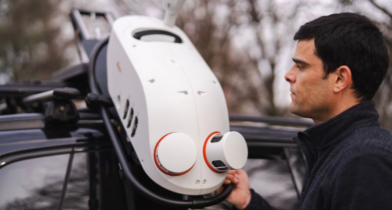
Featuring a simple single-mount system, the operator can single-handedly and safely slide the TRK into position rather than lifting it above their head.
Efficiency isn’t just about the time and resources saved to benefit the bottom line. Faster data capture means more time to make considered decisions, which in turn will lead to higher quality results.
Win the bigger projects
More time means more capacity, which results in more revenue.
UK surveyors Severn Partnership invested in an integrated mobile mapping and GPR solution to win larger infrastructure contracts and diversify beyond traditional surveying. They can now offer clients 2D utility plans and rich 3D digital twins, and the gains in speed, safety, and efficiency helped them win major civil engineering contracts, airport utility surveys, and specialist work such as mapping a Formula E racetrack.
Speed can also decide whether a job is winnable at all. On the Midland Mainline Electrification project, SPL Powerlines needed a safer, faster alternative to traditional surveying. Using the Pegasus TRK700 NEO across restricted railway corridors, they quadrupled their output from 4 miles to 20 miles per night.
Automation where it’s needed
After data capture, processing it back in the office has long been a time-consuming task for surveying teams.
Processing terabytes of raw data, like trajectory corrections when GNSS drops out, and spending hours manually matching targets has kept surveyors at their desks for long hours.
With Leica Pegasus OFFICE, much of the heavy lifting becomes automated, such as trajectory processing, correcting IMU drift, and georeferencing point clouds.
The software uses cloud-to-cloud registration, which aligns multiple point clouds automatically, with no survey targets required. It copes with awkward environments, such as tunnels with varying ceiling heights or junctions with complex geometry, without time-consuming manual intervention.
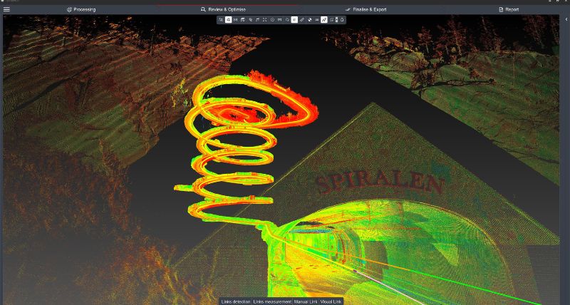
With cloud-to-cloud registration in Pegasus OFFICE, even the most complex of assets, like this spiral tunnel in Norway, can be accurately mapped and quickly adjusted. The offsets were 10-15 cm without any adjustments and improved to around 2 cm after adjustment.
Where control points are used, the built-in Automatic Target Recognition (ATR) finds survey targets or painted markers and matches them across tracks, turning hours of point-by-point work into minutes. The surveyor’s time goes into quality checks and building the deliverable rather than fighting the data.
The results of this automation show up in practice. Veris, an Australian geospatial consultancy, reported their post-processing time fell by fifty per cent when they MMS. The team assessed pavement profiles along a 3km section of busy freeway in Adelaide, capturing high-density LiDAR and 360° imagery at traffic speed.
Capture once, use many times
The lasting value of MMS is felt after the first project.
Because one pass records the whole environment, new deliverables can be extracted later without a return trip. An asset register today can become a drainage analysis or pavement condition report next month, and the original capture keeps paying back.
Road and highway surveys are a good example. A colourised, georeferenced point cloud can support safety reviews, corridor and road-design planning, bridge-clearance assessments, rockface modelling, volume surveys, utility and powerline extraction, and as-built documentation for roads, tunnels and bridges. Combined with a ground-penetrating radar (GPR) system, a single drive can capture subterranean features, as well as surface features, simultaneously.
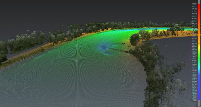
Marine surveys are another example. An MMS can be paired with a multibeam echo sounder on the same vessel to produce a single georeferenced dataset above and below the waterline, plus 360° imagery. That opens up ports, canals, rivers and waterways, from clearance and navigation-safety surveys to environmental monitoring and infrastructure inspection.
When combined with a multi-beam echo sounder, data captured using the Pegasus TRK creates a detailed above- and below-surface point cloud. .
Let the software do the heavy lifting
For extraction, AI-assisted extraction platforms working natively with the Pegasus TRK offer huge efficiency gains.
Point-clouds generated from the Pegasus TRK can be easily converted into a highly accurate 3D model with Leica Cyclone 3DR, extracting detailed and accurate terrain models with in-built smart filters to easily differentiate vegetation, terrain, noisy points, or build structures. Cyclone 3DR also uses AI segmentation tools and powerful scripting to enhance accuracy and efficiency in data processing and task automation.
Third-party providers like Mach9 can also automate much of the heavy lifting. This significantly cuts the time and labour cost of turning raw scans into finished deliverables.
Mach9 Digital Surveyor 2 natively integrates with Leica Geosystems' LGSx data format, preserving the full, high-res, 360° panorama images. This means there’s a direct, seamless path from registered point cloud to final output with no re-processing or wasted hours reconciling data between systems.
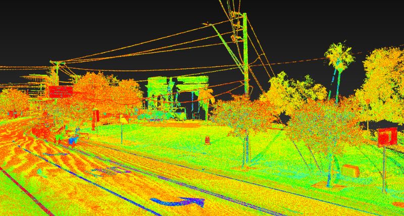
The Pegasus TRK is equipped to accurately capture the road width, condition, roadside vegetation, and overhead utility lines at the same time.
Take the next step towards new revenue
Whether it is for road, rail, underground utilities, smart city, or marine projects, mobile mapping supports your team and your business in three key ways. Work is done faster, and the most time-consuming tasks become automated, one dataset has many uses, and your business gains more time and credibility for larger and more complex contracts. .


.jpg?sc_lang=en&hash=9400E5E93E33DA1FE643F724574B105C)