


Discover Leica Geosystems airborne bathymetric solutions at Oceanology International 2016

The Airborne Bathymetric LiDAR team of Leica Geosystems will be exhibiting their solutions at the 46th edition of the Oceanology International event in London from 15 – 17 March 2016.
Oceanology International is the world’s leading forum where industry, academia and government share knowledge and connect with the marine science and ocean technology communities.

Solutions for nautical charting and maritime monitoring
Leica Geosystems will present its airborne bathymetric sensors, providing solutions for hydrographers and surveyors working with nautical charting, marine environment, coastal monitoring and global warming effects.
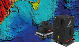
Surveying in the coastal region is a challenging undertaking using traditional multibeam and boat technology. Unlike charting from a boat, the Leica Chiroptera II and the Leica HawkEye III airborne LiDAR sensors are not limited by the challenges of near-shore surveying, such as submerged hazardous objects, and provide seamless data between water and land.
Nautical charting in the near-shore area delivers the data and knowledge needed for safe shipping, coastal erosion and the impact of rising sea levels due to global warming. It also provides information regarding marine life and vegetation.
Proven productivity in coastal surveying
Visit the Leica Geosystems team at stand P425 to learn about proven and cost-effective airborne surveying in the near-shore and coastal areas and to get a demonstration on sample data from all kinds of surveys and coastal environment around the world.
Click here for more information on the Oceanology International 2016
Click here for more information on Leica Geosystems’ bathymetric / hydrographic sensors

Case Studies
Découvrez comment les clients de partout dans le monde déploient des solutions Leica Geosystems pour leurs projets.
Découvrez comment les clients de partout dans le monde déploient des solutions Leica Geosystems pour leurs projets.

Contacter Leica Geosystems
Une question ? Vous souhaitez voir une démonstration ?
Une question ? Vous souhaitez voir une démonstration ?