


Map360 Scene Mapping and Reconstruction Software - Standard

With Map360 Standard edition, police officers and investigators can create accurate and impactful visuals to communicate all the critical details of a crime, crash or fire scene with diagrams, incident reconstructions, renderings, animations, flythroughs, and other courtroom exhibits.
3D visuals created in the forensic mapping software offer the viewers a better spatial understanding of the scene. Map360 Standard provides professional 2D/3D CAD diagramming, animation and integrated workflows that precisely represent all details of the incident scene.
Move fluidly between 2D and 3D environments, enhancing the outcome and the quality of incident reconstructions. Map360 Standard builds on the Sketch edition, where users can import points, drone images, ortho slices, Bing Maps, or use manual measurements to create basic diagrams and deliverables. Map360 Standard supports laser scanning, total station, and GNSS data but also projects created with the Evidence Recorder (EVR), Leica Captivate, or LTI. The full 3D capabilities and analysis tools are included for all kinds of crime, crash, and fire scenes: from basic to complex.Contact our Public Safety, Security and Forensics experts

Turn a 2D sketch into an array of compelling 3D deliverables
Leica Map360 Standard builds on the Sketch edition, turning a 2D diagram into an array of 3D deliverables. The compatibility between those two editions allows the seamless transition between 2D and 3D environments. Map360 Standard supports total station data, GNSS data, and projects directly from the Evidence Recorder (EVR) and the Leica Captivate software. The full 3D capabilities and all analysis tools are included to create a wide range of court-ready deliverables for basic to complex incident scenes.
Map360 Standard - Forensic Mapping Solution with 2D and 3D Capabilities
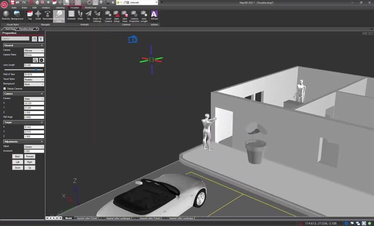
Visualize the scene from various perspectives
Navigate through a 3D scene with intuitive controls and visualize the scene from various perspectives. Cameras provide specific views of the scene that a user can return to, including a Witness view.
Corroborate or disprove witness statements about what they could or could not see during an incident. The crime, crash or fire scene can be rendered to provide a realistic view utilizing the measured scene data.
Step 1
Explore the 3D scene with the orbit feature to view the scene from different perspectives. Save a camera at the current view and give it a unique name.
Step 2
Insert a camera from the witness's perspective. Rename the camera and adjust the camera's position from the properties panel.
Step 3
Insert a camera at the shooter position. Use the properties panel again to re-position the camera. Preview the camera positioning to ensure the correct view is established. Use the panorama function to look around.
Step 4
Insert a camera from the clerk position at ground level. From the properties panel, switch the static camera to the witness view and enter the height.
Step 5
Use the walk or the fly tools to move fluidly through the scene. Adjust the visual styles to render the appearance of objects and provide a realistic view.
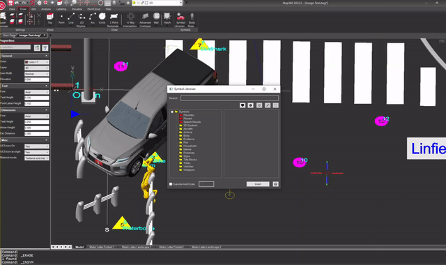
Visualise objects at the scene with realistic 3D models
Map360 includes a large collection of 2D and 3D models in the symbol library. With Map360 Standard, users can visualise the measured objects at the scene with realistic 3D models of vehicles, furniture, weapons, and more for compelling court-ready deliverables.
Easily adjust the orientation and position of various objects in the drawing using interactive controls. The symbol library, including highly detailed 3D models, grows continuously. Customized or additional models from external sources can also be imported and used within Leica Map360 software.
Step 1
Add 3D realistic symbols to the scene using the symbol library.
Step 2
Take advantage of external symbols by downloading the collada file.
Step 3
Easily import external symbols into Map360 Standard.
Step 4
Quickly and accurately place your 3D symbols at the incident scene.
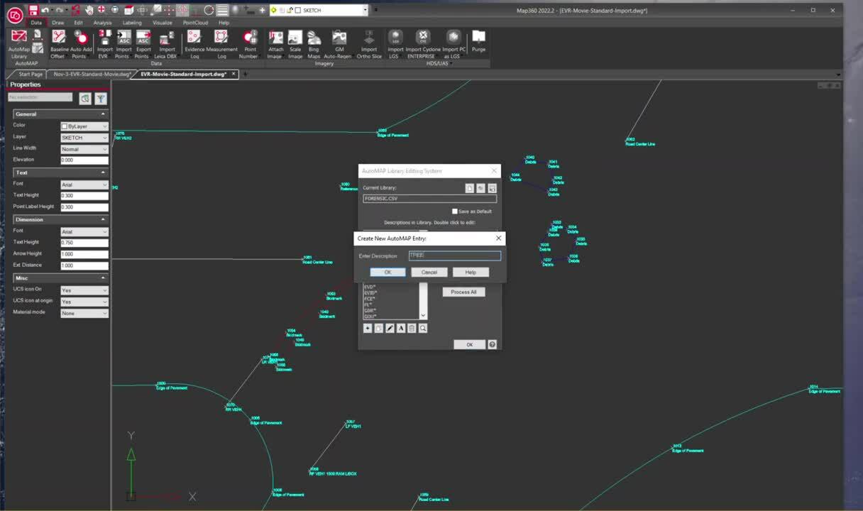
Quickly and accurately capture scene data and view the measurements directly at the scene
Evidence Recorder (EVR) is a data collection software to capture scene data and view the measurements directly on-site, at the scene, quickly and accurately.
Maximize efficiency with the AutoMap file, using common descriptions to connect the measured points with linework. A symbol linked to a description will be automatically inserted at the correct location in the drawing. Create accurate and compelling diagrams in minutes by importing the scene measurements and line work into Map360, including your photos and written- and audio notes.
Step 1
Import your project into Map360 Standard from Leica Evidence Recorder.
Step 2
After importing your project, Map360 Standard will automatically draw road lines and points.
Step 3
Assign a symbol to an entry to improve and streamline common visuals.
Step 4
Use the quick align function to adjust symbols accurately in your scene.
Contact our Public Safety, Security and Forensics experts

LEARN IT - Online school
Learn the first steps of Map360 Standard by participating in a self-led on-demand online environment.
Learn the first steps of Map360 Standard by participating in a self-led on-demand online environment.

TRY IT - Demo download
Test drive Map360 Standard with a fully functional 30 day copy. See for yourself if it’s the right fit.
Test drive Map360 Standard with a fully functional 30 day copy. See for yourself if it’s the right fit.

BUY IT - Online Store
Looking for a copy of Map360 Standard? Purchase online in our secure environment.
Looking for a copy of Map360 Standard? Purchase online in our secure environment.

Ezért válasszon minket
Közvetlen tanács, konzultáció és gyakorlati segítség. A köz- és magánszféra szervezeteinek olyan megbízható partnere vagyunk, amely megbízható szolgáltatás és szakértelem mellett a térinformatikai eszközök lehető legszélesebb portfólióját kínálja.
Közvetlen tanács, konzultáció és gyakorlati segítség. A köz- és magánszféra szervezeteinek olyan megbízható partnere vagyunk, amely megbízható szolgáltatás és szakértelem...

Alkalmazások
Szaktudásunk világszerte szolgálja a közbiztonsági szakembereket, és újradefiniálja azt, ahogyan a bűnüldöző szervek munkatársai az incidensek kivizsgálását és a helyszínelést, a bizonyítékgyűjtést és a bűnügyi térképezést kezelik.
Szaktudásunk világszerte szolgálja a közbiztonsági szakembereket, és újradefiniálja azt, ahogyan a bűnüldöző szervek munkatársai az incidensek kivizsgálását és a...

Megoldások
A valóságrögzítést, a helyszínelést vagy a helyszín rekonstruálását, a pontos helymeghatározást és a helymeghatározási információkat célzó megoldásaink előnyt biztosítanak a Forensic Digital Twin (Kriminalisztikai digitális iker) megalkotásában.
A valóságrögzítést, a helyszínelést vagy a helyszín rekonstruálását, a pontos helymeghatározást és a helymeghatározási információkat célzó megoldásaink előnyt biztosítanak...

Oktatási központ
Akár a hagyományos dokumentálási módszereken szeretne túllépni, akár a technológiát szeretné elsajátítani, képzési erőforrásaink a napi munkája minden lépését támogatják.
Akár a hagyományos dokumentálási módszereken szeretne túllépni, akár a technológiát szeretné elsajátítani, képzési erőforrásaink a napi munkája minden lépését támogatják.