


Helping Businesses Grow Tricad Solutions Ltd
How problem-solving solutions are helping businesses grow

How problem-solving solutions are helping businesses grow
Based in Lancashire’s Ribble Valley, TriCAD Solutions ltd. have been trading and growing for almost two decades. The team has built up a sizable client list, carrying out topographic and measured building surveys for architect’s practices across the Northwest of England.
Founded in 2002, TriCAD began with just a Leica Sprinter 100 optical level and a Leica DISTO. Now however, they are operating a fleet of six Total Stations, six GNSS antennas, one ScanStation P20, one RTC360 3D reality capture solution and the associated software. Running this fleet of Leica Total Stations and GNSS solutions has allowed the TriCAD business to grow at an admirable pace. This has led them to the requirement for further recruitment and regular review of the technologies used to keep up with the pace of their growing workload. To enable faster data capture, the team invested in first the Scan Station P20, and latterly the RTC360 scanner, allowing them to get involved in projects such as the capture of the famous Blackpool piers for modelling.
The Growth of TriCAD Solutions
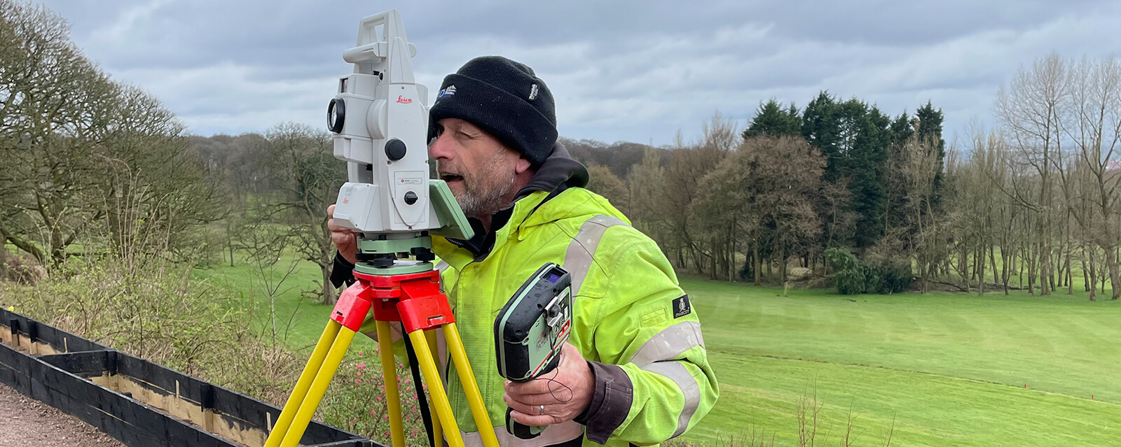
Leica Geosystems have supported the growth of TriCAD Solutions for many years. As their business has grown so too has their range of enquiries, so much so that TriCAD are now regularly receiving repeat enquiries about structural monitoring projects from clients they’ve worked with over the years. The team at TriCAD Solutions saw this as an opportunity to enhance their offering to clients and further grow their business. In anticipation of these enquiries and expanding into monitoring, TriCAD Solutions invested in a 1“ LeicaTS16 Total Station.
Haigh Hall: A Case Study
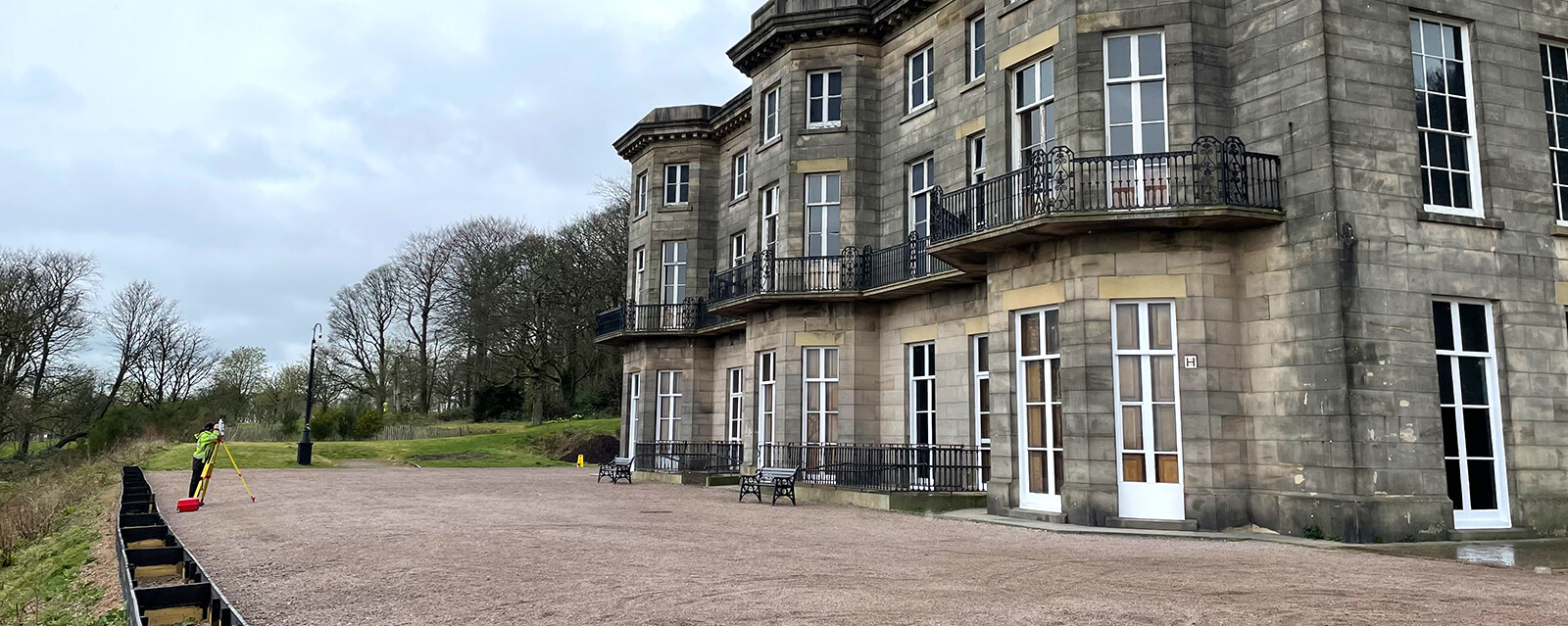
Following several successful ventures into basic manual monitoring schemes, TriCAD were contracted to take on a project to monitor movement in the structure of Haigh Hall near Wigan on a bi-weekly basis.
The challenge
Haigh Hall is surrounded on three sides by open land, much of which is a golf course. On the fourth side is a narrow passageway bounded by a step and a high wooded bank. None of the surrounding land lent itself favourably for the positioning of permanent control. This was compounded by the fact that the land is all open access public parkland, so the security of any placed control may be compromised.
The solution
TriCAD approached Leica Geosystems to ask for advice on overcoming the problem of establishing control. As site visits would be bi-weekly, TriCAD wanted to avoid setting up tripods over nails, as instantly this would introduce centring and height errors into the measurements that they are recording to monitor the structure. TriCAD also wanted to be able to position circular prisms to enable the utilisation of the TS16’s ATR+, allowing them to make use of the Resection Setup routine to place the instrument in front of the building face to measure the targets.
The answer was to drill into the road surface and place an expansion bolt with a screw thread at the top. Into this, a placed bayonet fitted stub, and finally onto that a Leica GPR121 prism. Upon departure from the site, the stub was removed and replaced with a threaded nylon plug to keep the expansion bolt clean from a collection of debris. From this point on, TriCAD were able to follow the standard survey practice of traversing around the building to establish control, and using Measure Sets on the instrument to measure rounds of angles to the back-sight and fore-sight, as well as the stub points in the ground.
“We have a fantastic relationship with the whole team at Leica. The service team is first class and really helps in keeping our kit in top condition. Also, the sales and technical team give us great advice on projects like these and whenever we wanted to try anything new. We really enjoy working with them all and look forward to continuing to do so in the future.”
Mark Drummond | Director - TriCAD Solutions ltd., United Kingdom
When processing the captured data, the measurements were all processed as one network in Leica Infinity. The measurement of the 70 monitor points across the building was managed using the Measure Sets application to turn the instrument to the points before pausing for manual sighting prior to measuring. The measurement records were then reported utilising the time series graphs in Leica Infinity to show dX,dY dZ values to the originally measured point.
This solution maintained standard survey practice, which was made possible by the access to the host of accessories sold through Leica Geosystems’ internal distribution partner SCCS Survey Equipment.
Our Customers Success is Our Success
Leica Geosystems have worked with TriCAD for twenty years, supporting them with advice every step of the way. This has allowed us to build a very trusting and loyal relationship that works both ways.
Through the greater Hexagon family, in this case, SCCS Survey Equipment, Leica Geosystems have been able to solve a survey problem on this particular project through the range of accessories which we can provide quickly, easily and at a relatively low cost.
A simple solution that is not about technology, but about service. We implement this collaborative, problem-solving approach in all of our customer projects.
Sometimes hitting a bump in the road can put companies off expanding into new fields. But with Leica’s support, we’re confident that more land survey companies will thrive in the industry of small-scale monitoring schemes.

Halaman industri Pure Surveying baru
Pelajari solusi survei baru dari kami untuk mengembangkan bisnis Anda serta pelatihan untuk meningkatkan kemampuan diri atau tim Anda, sekedar untuk mengetahui kabar...