Blessing research and education with new ATHENA updates

The ATHENA Programme has been updated with the latest Leica Geosystems GNSS receivers and antennas.
Springing from the head of the king of the gods Zeus, fully grown and armored, Athena is the goddess of wisdom in Greek mythology. With such a powerful beginning, one might think that the goddess could not advance any further. Quite the contrary, Athena feats in gathering more and more knowledge and sharing with mankind are legendary.
Like the goathena-icon-logo-cmyk-128x128px-0616ddess’ continuous development and lessons, the Leica Geosystems ATHENA Programme has also progressed. The Advanced Technology for Higher Education and Nonprofit Associations (ATHENA) Programme introduces the latest GNSS and Monitoring technology to the academic and research communities. The foundation of the ATHENA Programme is a set of Leica Geosystems GNSS reference station and structural monitoring bundles specifically designed and priced to benefit universities and research institutions
The latest update to the programme introduces the new:
Frank Pache,
ATHENA Programme manager
"ATHENA helps universities, research organisations, and others in higher education to better facilitate the use of GNSS reference stations and structural monitoring technology for both teaching and scientific research purposes," said Frank Pache, Leica Geosystems GNSS Network & Reference Stations senior product manager and ATHENA Programme manager. "With the continuation of the ATHENA Program, we want to meet and exceed their expectations by extending this proposal of affordable GNSS reference station and monitoring technology to every nonprofit organisation around the world."
Unique bundles for unique opportunities
Whether you need to track or observe, the ATHENA Programme offers two types of convenient and tailored bundles.
1) GNSS Reference Station Bundles
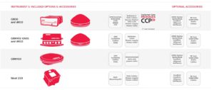
Select a bundle consisting of a multi-frequency GNSS (GPS, GLONASS, Galileo, BeiDou & QZSS) capable receiver and antenna of your choice.
The GR50 and GR30 are web enabled GNSS reference servers with streamlined workflow and advanced data management features. They are ideal for a variety of real-time positions and fast motion monitoring applications.
The AR10 is the most economic wideband reference station antenna with a large ground plane and integrated radome. The Leica AR20 is the high-end standard choke ring with unmatched multipath rejection, excellent phase centre characteristics and very low noise signal tracking. The Leica AR25 is a revolutionary 3D choke ring that sets new standards in low elevation tracking.
2) Monitoring Technology Bundles
Leica Geosystems innovative monitoring solutions use the latest in cutting edge technology. The range of high precision GNSS and tilt sensors offered in the ATHENA Programme offer an unique opportunity for research and educational institutions to enter the world of structural monitoring.
The GM30 is designed for continuous operations and diversity of monitoring scenarios. This receiver is packed with full feature on-board software including site monitor, Leica VADASE, data logging and FTP push.
The Nivel 210 Inclination Sensor provides highly-accurate measurements and long-range stability for large structure monitoring and engineering projects.
The GMX910 is designed specifically for monitoring with high precision. Boasting multi-frequency, multi-system GNSS receivers, this monitoring solution picks up the most sensitive of movements.
Each bundle includes the essential accessories. A wide range of optional software, such as Leica GNSS Spider, SpiderWeb and SpiderQC, are available to complement your ATHENA bundle.
With the one year Customer Care Package (CCP) included, you gain access to the latest firmware releases as well as our qualified customer support team.
How can you participate?
Universities and other research organisations around the world are profiting from the ATHENA Programme.
“The ATHENA Programme has been a valuable source of leading-edge geodetic equipment for NOA (National Observatory of Athens) so that we can monitor tectonic deformation in Greece,” said Dr. Athanassios Ganas, Institute of Geodynamics, NOA, Research Director. “Leica Geosystems reference stations were extremely important source of data in producing highly accurate research results, which were further used in scientific journal articles and further research on topics such as strain and rotation rate patterns of the Earth, displacements after earthquakes, and dynamic characteristics of seismic waves.”
If you are:
-
An academic organisation – University, polytechnic, higher education college
-
A research institution
-
A current registered member of University NAVSTAR Consortium (UNAVCO)
-
An organisation specifically involved in non-profit activities
Contact your local Leica Geosystems representative today to learn how you can keep advancing your knowledge with ATHENA.


