New features significant enhancements to LISCAD

LISTECH V12.1 is now available.
LISCAD is used by thousands of customers in more than 100 countries. This surveying and engineering software interfaces with all popular surveying, engineering and CAD systems, is intuitive to use, free to evaluate, and quick to learn with comprehensive tutorials and fast technical support.
LISCAD features:
- Rigorous geodetic computations
- Unlimited model size
- Least squares adjustment
- 2D/3D transformations
- Volumes
- Background images
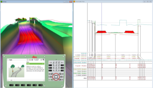
- 3D visualisation
- Point cloud processing
- Profiles
- Impressive design capability
- Real time TPS/GNSS surveying and setout
New release brings new features

With LISCAD V12.1, you can take your surveying and engineering feats further than ever before. New features and significant enhancements include:
- Create Arc by Tangent, Radius and Arc distance, or Chord distance
- New computations arc creation methods
- Groups can have prefixes and suffixes
- Prefixes and suffixes can be added to or removed from any selection of group names, making it very easy to keep separation of similarly grouped data originating from different sources
- Line Grades and Flow Arrows Output to CAD
- New CAD Output options show grades and flow arrows for lines in the CAD file
- Line Grade Reporting
- The Lines report can now optionally include line grades
- MX triangulation imported as LISCAD model
- Import of Moss (MX) GENIO now supports MX triangulation which is imported into SEE as a model
- Additional Angle Rounds techniques supported
- BBFF (FL, FR, FR, FL or FL, FR, FL, FR) angle rounds now supported in the field file for reduction to a Traverse, Least Squares Adjustment and Rounds report
- Optional Scaling of Line-types via CAD Output
- Line-types may be optionally scaled when output to AutoCAD or MicroStation to suit the desired plot scale
- Leica RoadRunner Rail Export
- RoadRunner Rail export now available with two new style sheets
- MapInfo Export enhanced
- Alignments and arcs are exported as MapInfo polylines with user control over the point density
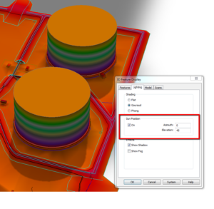
- 3D Display Features Lighting enhanced
- Enhanced shadowing based on sun position
- Auto Stringing of Cross Section sets
- "Transfer of cross sections to Plan" has been enhanced to allow automatic intelligent stringing. This is very useful as an alternative to using templating to create cross section stringing
- Cross Section Grades
- New cross section design and CAD Output options allow grade values to be generated in the graphical cross section output
- CAD Output of AutoCAD underlined text
- AutoCAD underline font is now supported via CAD Output
- Edit Point Attributes by Line
- Easily edit the attributes of all the points in lines simply by selecting the relevant lines
- CAD Output of Arcs to MicroStation enhanced
- New MicroStation CAD Output options to export arcs as 3D arcs, splines or polylines
For a free evaluation and complete details about LISCAD, please visit http://www.listech.com or e-mail info@listech.com .


