


.jpg?sc_lang=ko-kr&hash=5A380D418D403D88683EA1039550C56F)




고객의 측량 파트너
라이카 지오시스템즈는 유일하게 200년 동안 측량 업계에서 역사와 전통을 보유, 측량 프리미엄 품질의 측정 및 포지셔닝 솔루션과 서비스로 고객을 지원.
라이카 지오시스템즈는 유일하게 200년 동안 측량 업계에서 역사와 전통을 보유, 측량 프리미엄 품질의 측정 및 포지셔닝 솔루션과 서비스로 고객을 지원.


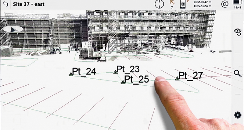
Leica Captivate field software was designed for surveyors who know how to push boundaries. With functionality ranging from simple to complex, there are no limits to the applications that can be mastered with Captivate. With immersive 3D renderings and easy-to-use touch technology, even the most complex projects can be easily conquered. Cloud connectivity ensures direct access to design and measurement data for easy and secure field-to-office communication.
Leica Captivate field software is a future-proof investment. Starting with total stations and GNSS, your company can grow into scanning with the MS60 MultiStation using the same Captivate field software and dataflow into the Leica Infinity office software. With full support of surveying, mapping and Building Information Modelling (BIM) formats, Captivate ensures that there will be no limits to growing your business into new areas.
Read how four different surveying companies have reduced unnecessary costs and delays by leveraging the benefits of Captivate.
Reduce training costs and have more flexible equipment and personnel deployment with all equipment standardised with Leica Captivate field software. With immersive 3D renderings of design models in the field and familiar apps with easy-to-use touch technology, Captivate ensures maximum productivity in the field. The Leica CS20 controller and the Leica CS30 and CS35 tablet, installed with Captivate, provide an enjoyable experience on the go. With cloud connectivity, easily and securely transfer design data to the field and measurement data to the office directly from within Captivate.
Check out our guide on what to look for when selecting a surveying field software.
The current selection of surveying controllers all run our field surveying software Leica Captivate. Whether you work with GNSS, total stations or both, you can use the same familiar software without changing workflows or dataflows. Deploy the best total station or GNSS for the job with the right field companion. Use our easy comparison chart to view our range of field tablets and controllers and easily select which suits your needs best. Download the comparison chart and decide for yourself.
Leica Captivate field software provides the functionality needed to complete all field tasks. Through the base functionality, and customised apps, Captivate includes intuitive apps to master all challenges. With a broad collection of online training assets, learning new functionality is only one click away. If help is needed in the field, a support engineer can connect directly to Captivate to ensure a rapid return to full productivity.
라이카 지오시스템즈는 유일하게 200년 동안 측량 업계에서 역사와 전통을 보유, 측량 프리미엄 품질의 측정 및 포지셔닝 솔루션과 서비스로 고객을 지원.
라이카 지오시스템즈는 유일하게 200년 동안 측량 업계에서 역사와 전통을 보유, 측량 프리미엄 품질의 측정 및 포지셔닝 솔루션과 서비스로 고객을 지원.


