


Off the boat, into the air

Author: Benjamin Federmann, October 2016
If you plan on driving from Kristiansand via Stavanger and Bergen to Trondheim, strap in for an approximately 1,100-kilometre ride that can take you up to 21 hours in the car on the European route E39. Due to the seven mayor fjords that must be crossed by ferry you get as well an extensively insight in the beautiful landscape of west Norway as the trip can get very protracted.
When the United Nations Economic commission for Europe (UNECE) decided 2008 in their “European agreement on main international traffic arteries” to create international standards to highway networks, the plan to expand the E39 was set. In the agreement, the “National Transport Plan” of the Norwegian government with the aim to upgrade the E39 to a road with an average speed of at least 80 to 100 km/h, a lane width of 3.5 meters and to avoid any ferry traffic.

To cut the trip on the E39 down to 10.5 hours, the Norwegian Public Roads Administration or “Statens vegvesen” is considering installing either suspension or floating bridges or sub-merged floating tunnels in the fjords to supersede the ferry traffic. The nearly 23 billion Euros infrastructure project would produce the world’s longest suspension bridge at a main span of 3,700 metres or the world’s first submerged floating tunnel to cross the Sognefjord.
The project began in early 2015 to transform the current two-lane high-way to four-lanes with an 11-km tunnel along with other road construction works. The entire project is scheduled for competition by 2035.
To keep construction on schedule and provide contractor oversight, Statens vegvesen contracted Hawkeye AS, a surveying firm specialising in final documentation of 3D deliverables and a joint venture of Veseth AS and Rune Samnøy of Samnøy AS, to provide orthophotos and models of the project. To do so, the 2014 founded firm turned to Leica Geosystems UAV (Unmanned Aerial Vehicle) solution to collect the needed imagery for tracking costs of mass movements, documenting progress and keeping stakeholders up-to-date. Using state-of-the-art technology on the flying multisensory platform helps to capture as many details as possible to create fine grained data.
A 360-degree view from above
Capturing data every two weeks with routine positions throughout the firm’s five-year contract on the project from January 2015 to January 2020, Veseth AS has created its own online gallery of 360-degree images taken with Leica Geosystems UAV solution and a special installation to mount a Nikon D800. To date, the gallery on http://360aircamdrone.net/e39sr/ hosts more than 100 photos since November 2015. The photos, taken at centimeter accuracy, are used in all construction meetings, helping Statens vegvesen to plan each step of the project. Project management uses the photos for quality control purposes with contractors and other stakeholders. The website is also a novelty when it comes to communication with the public. To increase transparency the public platform gives insights in the current project status, scheduled tasks and into important steps.
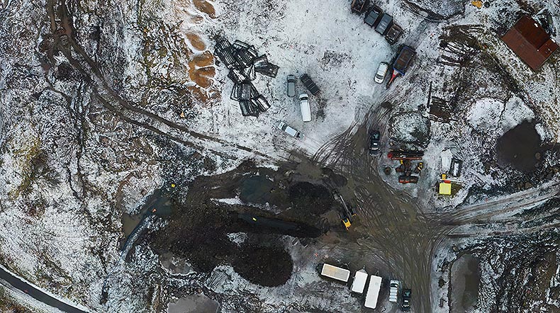
To create reliable and repeatable data on fixed positions, the company uses the in-house built flight planning software to adjust waypoints, height, rotation and angle of the camera. The software also provides information over the estimated duration of the mission, the envisaged route and with which GSD (Ground Sampling Distance) the pictures are taken.
“Providing aerial imagery from an UAV is new for us, and the excellent resolution of the pictures of different construction areas is helping the overall project to flow smoothly,” said Mads Solberg Eriksen, Statens vegvesen quality advisor. “The 360-degree view possible with Leica Geosystems UAV makes project documentation easier and faster.”
Seeing the whole picture
Hawkeye AS and Veseth AS are particularly known for its volume calculation of terrain both above and below water. As a major challenge to the project has been the mass removal of non-native plants to the natural habitat during the construction of the 11-km tunnel, the firm has been combining several Leica Geosystems solutions for precise volume calculations and documentation. Whereas Leica Geosystems UAV provides a clear view with its 36.3 megapixel Nikon D800 from above for quality control, the firm uses a Leica Geosystem C10 ScanStation and Leica Geosystems Cyclone software to create detailed 3D models of the mass to be removed. The Leica Geosystem TS16 total station and GNSS solutions provide accurate measurements for quantity surveys. With the accuracy of the Leica Geosystems ScanStation C10, the laser scanner generates detailed point clouds even on long range up to 300m with its full 360º x 270º field-of-view.
“With Leica Geosystems solutions, we are able to provide the client with the most up-to-date information faster than ever before,” said Stian Veseth, Veseth AS CEO and part of the joint venture company Hawkeye AS. “We are able to rely on solutions that work every day like they should, and we have complete access to a network of experienced professionals that we use to stay ahead in business.”
Combining the various solutions, the firm is consistently able to provide the client with a full picture of the worksite from above ground and below the water of the fjords. One of the biggest infrastructure projects in Norway’s history, the reconstruction of the E39 highways proves how UAVs compliment traditional surveying practices for an even bigger and clearer picture of what exactly is happening.

Reporter 76
Download your own PDF edition of the "Reporter 76" here.
Download your own PDF edition of the "Reporter 76" here.

Contact opnemen met Leica Geosystems?
Vind uw lokale Leica Geosystems vertegenwoordiging voor verkoop, support en technische service.
Vind uw lokale Leica Geosystems vertegenwoordiging voor verkoop, support en technische service.