


Keep connected with Leica Captivate cloud services
Dive into our supported cloud-based services and see how they can improve your workflow.

Author: Zühal Duran Goeminne
Zühal Duran Goeminne, our Product Engineer, joined us for an insightful chat on Leica Captivate cloud services. Read all about cloud-based services in Captivate.
Many people have seen recent posts showing that Leica Geosystems and third-party collaborators have cloud-based data management solutions. Before we talk about supported cloud services, perhaps you can tell us why companies would need a data management solution at all?
In the USA alone, people generate a staggering 4 million GB of data per minute on the internet, according to the cloud-based operating system Domo. This is only the data being generated by individuals on the internet. Many companies also routinely generate massive amounts of data, for surveyors and engineers this can often be specialised datasets like point clouds, 3D BIM models, or complete surveys. Suppose employees just save their data on their personal computers or leave it on a server without proper data management procedures – things could escalate very quickly. Without proper data management, valuable data can get lost or become inaccessible, and many hours of company time will be wasted trying to retrieve and understand poorly annotated datasets. Inconsistencies in the data might also lead to wrong interpretations. Emerson Reliability Consulting recently reported that on average 30% of the data created during the design and construction of a project is lost when the project is finished (further information is available in the Online Course “Connecting the Dots Between Office and Field Using BIM360 Docs” by Deepak Maini & Aaron Coats).
A proper data management solution ensures that all your data adheres to the so-called FAIR principles (Findable, Accessible, Interoperable and Reusable). The FAIR concept originates from the scientific community to encourage open science. Still, its principles are universally valid, even when the number of people who have access to the data is limited, as is typically the case within a company. Even if you are the only person who has access to the data, if you need to re-access your data in a few months, you are sharing with “your future self”.
Therefore, the data must remain easily accessible and operable while being stored securely and safely. Following that, two topics came into prominence: “easy access to data” and “making data available”. Accessibility and reachability of data have made data management a great deal more important. However, the more data is being generated, the more management is generally needed.
Ok, I see your point – but why is it needed to store data in the cloud? Isn’t it sufficient and safer if companies just store their data on their own secure servers?
Absolutely not. According to Emerson Reliability Consulting, in 2020, 62% of the field construction professionals still transfer their data via spreadsheets or storage media methods. This process is not only tedious and time-consuming but also carries risks. Data might become corrupted on the devices, and the device might get lost, data lingers around on the device and might fall into the wrong hands. A crash of or ransomware attack on the office computer(s) might lead to severe data loss if no proper back-ups were made.
Cloud-based data management is a central location where all your data is stored on an off-site server. The data you save, organise, edit, and make accessible is shared with authorised persons. Cloud services store your data securely and encrypted on a network of heavily guarded servers in different physical locations with high-level cybersecurity. These measures make the cloud much more robust against data corruption or malware attacks than a typical company network or private hard drive.

Now tell us about the supported cloud services – what are these services and how do they contribute to your project workflow?
With Captivate's latest release, we support the Leica Exchange, Leica ConX, BIM360 Docs, and Bricsys 24/7 cloud services.
When we consider the benefit of online services in the world of surveying and engineering, easy access to data gains incredible importance for an engineer working in the office and in the field, both in terms of saving time, enhances the workflow on both directions, and tracking and keeping up to date on project tasks.
So let us touch the different cloud services and connectivity options Leica Geosystems has in store for the users, starting with Leica Exchange.
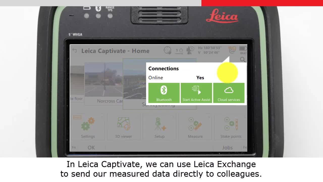
Leica Exchange is an online data organisation tool that allows selecting data from your computer, storage media, or network and sends them directly to any office or field crew. With the data transfer of Exchange, the user is informed about the transfer status instantly, whether the data has been sent or is still in process, showing what percentage of the data is included in the transfer. To use this file transfer service, you need an Exchange subscription. In the field, Leica Captivate sends completed field jobs back to the office over-the air, seamlessly connecting the office and the field. With it, you send jobs and files from your local computer to any office or field crew all over the world. Thus, every surveyor can periodically send their measured data to the office for further processing directly in Infinity or other office software. Leica Exchange offers the flexibility to include or exclude any field job data before sending, giving you complete flexibility to add images and map files folders in the job data, or not. It makes it so much easier to transfer data securely and eliminates the tedious process of saving the data on an external device, take it to the office, deliver it to the field and office crew, and then copy it again on a computer. With Leica Exchange, you can also transfer Leica Infinity data, regardless of the format.
How about Leica ConX?
Leica ConX is a cloud-based web solution widely used to transfer data between Leica Geosystems machine control products and data exchange between the field and the Captivate office. In this cloud service, a surveyor can easily send field-related jobs to a pre-created ConX project and retrieve processed data from the office. This gives a competitive advantage by streamlining the flow of information between construction teams on-site and in the office.
ConX uses role-based access control, which means you can create user roles where a project member will have full or limited permissions, depending on the project. It is possible to create a structure that reflects your company's hierarchy, allowing results to be collected for different hierarchical levels.
To exchange surveying data with ConX in Captivate, a Leica ConX license is needed. The first time you connect to ConX, a pairing code appears on the screen. This code is entered in the relevant field in the web service, and after the pairing is successful, the user can upload and download data from a ConX project. The measured data can be synchronised periodically with the cloud, and the user can receive automatic notifications in case of a project update.
Can you tell us more about BIM360 Docs?
BIM360 Docs is cloud-based-construction document management that allows all project documents to be stored, viewed, and shared among project members in one centralised database. Surveyors can directly send Captivate job data to an existing BIM360 project and retrieve the modified data from the office. Viewing data in BIM Docs allows you to instantly check construction drawings and models without the need for any other applications. Besides, one would wonder how to keep track of project files. If you have ever worked on a project, regardless of its scale, you realised how quickly files are changed and updated in parallel. This is where BIM Docs comes into play. BIM Docs creates a version-control system that keeps track of what is current but preserves previous versions. This allows the user to effortlessly access these earlier files and revert to them if unwanted changes were made along the road. Furthermore, users can easily compare different versions at any time, whereby Leica Captivate highlights all differences to present a comprehensive overview of all changes.
On the office side, Autodesk product users can quickly share design files and documentation with field teams by sending them to Captivate, which contributes to improving data flow and saving project time. From the field perspective, a surveyor can easily send as-built measurements back from Captivate to Docs.
Leica now also supports Bricsys 24/7, can you explain what customers should know about this prominent collaboration tool?
Bricsys 24/7 is a cloud-based service for document management and workflow automation. It allows sending data through the cloud directly from the field to the office and vice versa. In Bricsys 24/7, perhaps the most interesting of its many features is that Bricsys 24/7 is directly connected to BricsCAD, Bricsys’s own CAD software, via a dockable panel. This saves the user time by eliminating one of the documents exchanging steps: users can update drawings or models in the design software and send them to the field without opening their browsers. In other words, the data exchange takes place directly between BricsCAD and Captivate, while Bricsys 24/7 runs in the background. Through the 24/7 panel, users can easily check the document's status with an icon indicating whether the document is in the cloud, if someone is currently working on it, if it is currently uploading, or if it is locked by someone to prevent modification. As in Docs, users can view project files in Bricsys 24/7's viewer without the need for native software. Bricsys 24/7 also includes version control and makes sure that users have access to the latest version of each document while tracking all earlier file versions. Captivate shows the most recent files by default but can also easily be configured to display previous document versions.
Every third party cloud service manages subscription-based licensing on its side, independent of Leica Geosystems.
In your opinion, what do these cloud services have in common?
It is increasingly common for us all to have our devices connected to the internet, either periodically, or continuously for a whole day – it is this internet connectivity that allows us to make use of the cloud data services, providing real-time data transfer and sharing anytime, any place.
Leica Exchange and Leica ConX licences are handled directly with your local Leica Geosystems representative – for the additional services authentication and/or licences may be required to access the service. For example, a valid BIM360 Docs license is needed to start using this online service in Captivate. The BIM360 server must be authenticated with existing Autodesk credentials and necessary to authorise BIM 360 to access Leica Captivate.
Are cloud services easy to use?
The process for all of these services is quite similar and very simple. Once you have the account set up and connected, you just enter the relevant Captivate service, select the data you want to send, and to whom or where you want it to go. The short video clip below shows us quickly how to send an entire job to a colleague by using Leica Exchange - and then sending that same data to a different colleague.
Where can our users get more information about these services?
For questions about purchasing products, subscribing to online services, or pricing, please contact your local Leica Geosystems distributor or service partner. You can find more information on our Sales & Support website.
Thank you for your insights, Zühal.

Zühal Duran Goeminne,
Product Engineer
In case you should have any additional questions regarding our software and/or hardware, please feel free to contact us.

Connecting measurement professionals to their data
Store, transfer and share your data efficiently between field and office to improve your data workflow with GeoCloud Drive, powered by HxDR.
Store, transfer and share your data efficiently between field and office to improve your data workflow with GeoCloud Drive, powered by HxDR.

Leica ConX
Leica ConX is a cloud-based collaboration tool that allows you to efficiently manage all your connected construction projects and to share job-related data with all stakeholders.
Leica ConX is a cloud-based collaboration tool that allows you to efficiently manage all your connected construction projects and to share job-related data with all...

Contact Leica Geosystems
Find your Leica Geosystems contact for sales, support and technical service.
Find your Leica Geosystems contact for sales, support and technical service.