Shore to floor: mobile mapping for marine surveys

Marine environments form a key part of our critical infrastructure. With sea levels rising faster than before, and the risk of flooding more present than ever, understanding and protecting this fast-changing environment is crucial.

Riverbanks, bridge undersides, quay walls, and channel beds all need mapping, not just for asset inspection and upkeep, but for navigation safety, flood defence planning, and environmental monitoring.

This, combined with mounting pressures on water authorities and municipalities to manage ageing waterway infrastructure, means more organisations are turning to complete 3D digital twins to capture rivers, canals, and marine assets to survey-grade detail.

However, because marine infrastructure is often more inaccessible, much of it hasn’t been mapped or surveyed as much as terrestrial assets.

Traditional terrestrial laser scanning can capture the bank, shore, and any above-water structures, while a multibeam echo sounder or bathymetric LiDAR sensor captures the riverbed. The difficulty with this approach is that the two datasets are often captured on different days by different teams, so they rarely share a common reference frame. This means that combining the two datasets is heavily time-consuming.

Mobile mapping systems (MMS), like the Leica Pegasus TRK, are a modern alternative, providing a flexible solution that can efficiently capture data from the water itself, allowing the survey team to quickly capture a large marine area in one pass. Mounted to a vessel, a single pass down a waterway captures a dense, georeferenced 3D point cloud, 360° imagery, and positioning data in one continuous session with no repeat visits. When combined with a multibeam echo sounder or bathymetric sensor, data can be captured below the water too, creating a dataset spanning the full above- and below-water profile.

Setting up MMS for the water

Setting up MMS for marine surveys follows a similar core mobile mapping workflow as other projects on land – mounting, initialisation, data capture, and analysis. When mapping on the water, elements within this workflow are adapted for a moving, often unpredictable, environment.

Mounting on a vessel

Unlike a road vehicle, where the Pegasus TRK is mounted facing forwards or backwards so its LiDAR beams hit the asphalt rather than the vehicle itself, orientation matters less on a boat. The system doesn’t need to scan the water surface, so it can sit centrally on the

Marine environments form a key part of our critical infrastructure. With sea levels rising faster than before, and the risk of flooding more present than ever, understanding and protecting this fast-changing environment is crucial.

Riverbanks, bridge undersides, quay walls, and channel beds all need mapping, not just for asset inspection and upkeep, but for navigation safety, flood defence planning, and environmental monitoring.

This, combined with mounting pressures on water authorities and municipalities to manage ageing waterway infrastructure, means more organisations are turning to complete 3D digital twins to capture rivers, canals, and marine assets to survey-grade detail.

However, because marine infrastructure is often more inaccessible, much of it hasn’t been mapped or surveyed as much as terrestrial assets.

Traditional terrestrial laser scanning can capture the bank, shore, and any above-water structures, while a multibeam echo sounder or bathymetric LiDAR sensor captures the riverbed. The difficulty with this approach is that the two datasets are often captured on different days by different teams, so they rarely share a common reference frame. This means that combining the two datasets is heavily time-consuming.

Mobile mapping systems (MMS), like the Leica Pegasus TRK, are a modern alternative, providing a flexible solution that can efficiently capture data from the water itself, allowing the survey team to quickly capture a large marine area in one pass. Mounted to a vessel, a single pass down a waterway captures a dense, georeferenced 3D point cloud, 360° imagery, and positioning data in one continuous session with no repeat visits. When combined with a multibeam echo sounder or bathymetric sensor, data can be captured below the water too, creating a dataset spanning the full above- and below-water profile.

Setting up MMS for the water

Setting up MMS for marine surveys follows a similar core mobile mapping workflow as other projects on land – mounting, initialisation, data capture, and analysis. When mapping on the water, elements within this workflow are adapted for a moving, often unpredictable, environment.

Mounting on a vessel

Unlike a road vehicle, where the Pegasus TRK is mounted facing forwards or backwards so its LiDAR beams hit the asphalt rather than the vehicle itself, orientation matters less on a boat. The system doesn’t need to scan the water surface, so it can sit centrally on the vessel.

The Pegasus TRK provides this flexibility because no two boats are the same and survey teams are often working with whatever vessel is available. As long as a team can securely fix the system, data capture can take place.
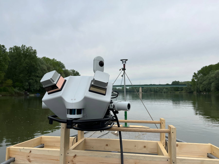
Leica Pegasus TRK mounted on a wooden platform on the River Drava, Hungary.

Initialising the system

Every mobile mapping mission begins and ends with initialisation, when the system establishes an accurate baseline for position, velocity, and orientation before movement introduces any errors. On a solid surface like a road, this is straightforward: stop the vehicle, and it's static. On water, even a slow drift or gentle current is enough to disturb the initialisation.

To solve this, marine survey teams should add a second GNSS antenna, fixed to the vessel at a minimum distance of 1.5 metres from the first antenna, to establish a stable position vector for initialisation and finalisation (the equivalent step performed at the end of the mission).

Having two GNSS antennas helps the static and dynamic alignment of the mobile mapping system during the mission. Each antenna has a target plate, meaning the main TRK sensor can easily register them and establish its position by automatically calculating the vector created by the two antennas.

Using bathymetric LiDAR or multibeam echo sounders

To capture underwater data, a bathymetric LiDAR or multibeam echo sounder must also be installed on the vessel before the survey begins. Leica Geosystems offers the capacity to synchronise the below-water sensors and mobile mapping system so that the superposition of above- and below-water data perfectly matches.

The TRK’s integrated GNSS and high-grade Inertial Measurement Unit (IMU) records vessel position and attitude, even when there’s no satellite signal. This provides a time stamp which synchronises the TRK and the multibeam echo sounder or bathymetric sensor so that data capture happens simultaneously.

To ensure consistency and accuracy, operators perform a spatial lever arm calculation to define the precise 3D distance offset (Dx, Dy, Dz) between the reference point on the Pegasus TRK (VLP rear) and the multibeam echo sounder or bathymetric device.

Bathymetric LiDAR sensors and multibeam echo sounders should be sourced from third-party providers.

Capturing and combining the data

Once the survey is underway, data capture from the TRK’s cameras, LiDAR, and positioning all feed into Leica Pegasus FIELD, giving operators a live view of point cloud density as they travel.

This real-time feedback is important as it allows teams to adjust their course to capture the necessary data, avoiding the need for rescans and saving time and money. Where a wide river surveyed down the centre line produces a less dense point cloud along the banks, operators can adjust their route to hug the bank more closely where vegetation or structures need denser capture, rather than discovering gaps later in post-processing.
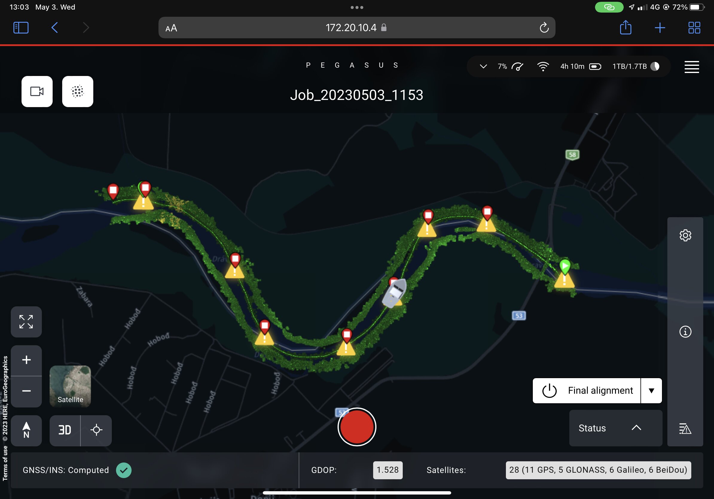
The vessel’s trajectory is tracked in Pegasus FIELD.

When a multibeam echo sounder or bathymetric sensor is integrated with the Leica Pegasus TRK, its below-water data is fused with the TRK's above-water point cloud in post-processing, using the shared positioning trajectory to align both datasets into one coherent model offering insight into both surface and underwater conditions.
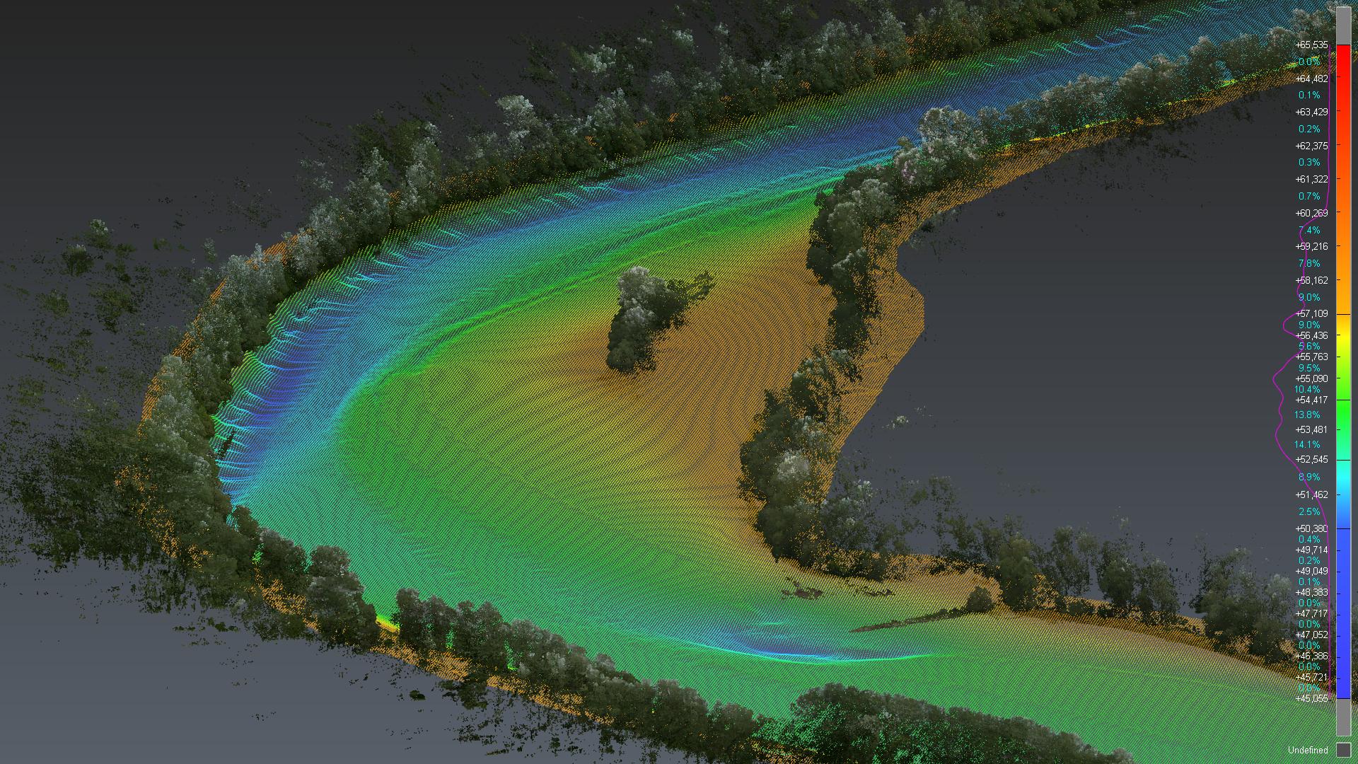
Water depth and riverbank density is captured in one point cloud with the TRK’s imaging and multibeam echo sounder/bathymetric integration capabilities.

How MMS helps solve marine challenges

MMS offers surveyors precision and repeatability.

Perhaps a current takes the vessel off course, or the water is particularly choppy making it difficult to keep the vessel on the right track. With the Pegasus TRK, a survey vessel can travel the same stretch of water more than once without creating inconsistencies, due to the accuracy of its positioning. If any inconsistencies occur, these are immediately flagged and corrected in post-processing in Leica Pegasus OFFICE, a task that would otherwise take hours to do manually.

As well as accurate positioning, with every survey, the TRK captures high-resolution imagery that can be used to spot encroachments, obstructions, and unauthorised structures along the waterway.

There’s no need to worry about water damage either. The system’s high IP rating (up to IP67 on the Pegasus TRK Neo) protects it from heavy spray and wet conditions without any additional housing required.

Passing briefly under a bridge causes a short GNSS outage, but on open water these are rarely long enough to matter as the IMU and GNSS combination can provide coverage over shorter gaps on their own.

Some marine environments can be narrow, such as river canyons or steep valleys, blocking GNSS signals. Traditional geodetic methods can fail to meet the required spatial accuracy in such areas due to signal blockage, multipath effects, and low satellite visibility.

The paired antennas and the TRK’s integrated SLAM LiDAR kick in once an outage passes 30 seconds, ensuring the IMU is stable and can compensate for any outages in GNSS-denied locations.

Monitoring rockfall risk in the Corinth Canal, Greece
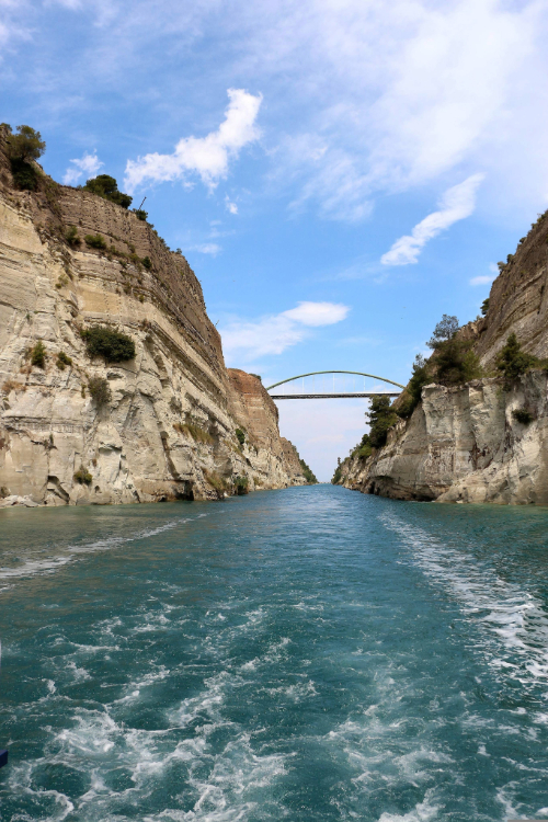

Left – the Corinth Canal, connecting the Peloponnese with mainland Greece.
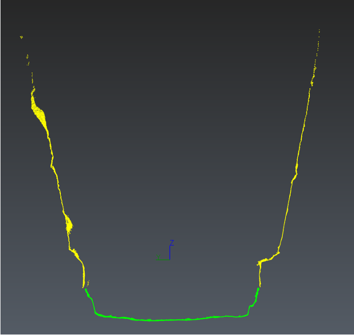
Right – a cross section of the Canal with perfectly aligned data from the Mobile Mapping System (yellow) and the multibeam echosounder (green).

The Corinth Canal is a critical shortcut for shipping traffic in Greece, linking the Ionian and Aegean seas. Without it, vessels would face a detour of hundreds of kilometres around the Peloponnese to reach mainland Greece. But the canal's steep walls are prone to rockfall, creating an ongoing hazard for passing ships.

Metrica, a leading Greek company in precision measurement solutions, specialising in marine, environmental, and construction applications, deployed the Pegasus to monitor the condition and stability of the canal’s cliffs, helping operators track changes to the rock face.

Due to the narrowness of the location, satellite navigation was unreliable and sometimes unavailable. The team also faced challenges including steep vertical canal walls, high seismicity, and active geological hazards.

With Pegasus, the Metrica team benefited from integrated LiDAR, GNSS/IMU navigation, and 360° imaging all feeding into a synchronised mobile platform capable of capturing terrestrial features with centimeter-level accuracy, even in GNSS-denied zones. As a result, they were able to provide the rich, accurate, and multi-scale datasets needed to validate, train, and deploy advanced risk mitigation systems.


Leica Pegasus TRK700 Neo mapping the Drava riverbanks in Hungary.

Core deliverables

Integrating mobile mapping systems into marine surveys generates rich, versatile data that fuels a wide spectrum of navigation, environmental, and engineering deliverables from a single pass.

This raw data can be used in multiple ways. Extract it into Pegasus OFFICE to create geo-referenced, photo-realistic point clouds with multi-pass trajectory optimisation to correct for IMU drift. Convert your point-cloud into a highly accurate 3D model with Cyclone 3DR to extract detailed and accurate terrain models in either TIN or DTM and use its in-built smart filters to easily differentiate vegetation from terrain, noisy points, or build structures. Data captured with the Leica MMS portfolio can also be transferred to a third-party environment for additional analysis, like a water-based GIS solution.

Combined above- and below-water digital twins

Combining the point cloud with multibeam echo sounders or bathymetric systems creates one coherent model of a waterway, replacing two disconnected legacy surveys with a single, aligned dataset for surveyors, engineers, and end users.

With this data, different companies can use the same model for more deliverables. For example, high-density point clouds would help a local environment agency understand and prevent flood risk while the below-water data maps water depth and helps port authorities determine the best cargo route.


Multibeam echo sounder and the Pegasus TRK were used to create a detailed point cloud showing riverbank density and water depth of the Drava river in Hungary.

High-density point cloud and imagery data also lets operators check bridge clearances, helping plan vessel routes and confirm whether a ship or barge can safely pass under a bridge.

Condition monitoring

Along canals and channels prone to rockfall or erosion, repeat surveys captured over time make it possible to track the condition and stability of cliffs, banks, and structures, flagging changes before they become hazards.

Detailed imagery for inspection and compliance

High-resolution 360° imagery captured alongside the point cloud is detailed enough to read signage on the riverbank or spot small, unauthorised structures, especially useful for compliance and encroachment monitoring along public waterways.


High-resolution 360° imagery enables users to zoom in and review even detailed signage.

Dive deeper with new survey capabilities

MMS captures rich above-water data rapidly and efficiently. It can be easily combined with multibeam echo sounders and bathymetric sensors on the same vessel to capture hybrid above and below water datasets. This means survey teams can make one pass capturing a georeferenced above- and below-water 3D point cloud, along with high-resolution 360° imagery and positioning data.

This flexibility opens up new survey opportunities across ports, canals, rivers, and waterways with applications spanning navigation safety and clearance surveys to environmental monitoring and infrastructure inspection – all in one system portfolio.

To find out more about the Pegasus portfolio, download our Workflow Guide.

vessel.

The Pegasus TRK provides this flexibility because no two boats are the same and survey teams are often working with whatever vessel is available. As long as a team can securely fix the system, data capture can take place.

Leica Pegasus TRK mounted on a wooden platform on the River Drava, Hungary.

Initialising the system

Every mobile mapping mission begins and ends with initialisation, when the system establishes an accurate baseline for position, velocity, and orientation before movement introduces any errors. On a solid surface like a road, this is straightforward: stop the vehicle, and it's static. On water, even a slow drift or gentle current is enough to disturb the initialisation.

To solve this, marine survey teams should add a second GNSS antenna, fixed to the vessel at a minimum distance of 1.5 metres from the first antenna, to establish a stable position vector for initialisation and finalisation (the equivalent step performed at the end of the mission).

Having two GNSS antennas helps the static and dynamic alignment of the mobile mapping system during the mission. Each antenna has a target plate, meaning the main TRK sensor can easily register them and establish its position by automatically calculating the vector created by the two antennas.

Using bathymetric LiDAR or multibeam echo sounders

To capture underwater data, a bathymetric LiDAR or multibeam echo sounder must also be installed on the vessel before the survey begins. Leica Geosystems offers the capacity to synchronise the below-water sensors and mobile mapping system so that the superposition of above- and below-water data perfectly matches.

The TRK’s integrated GNSS and high-grade Inertial Measurement Unit (IMU) records vessel position and attitude, even when there’s no satellite signal. This provides a time stamp which synchronises the TRK and the multibeam echo sounder or bathymetric sensor so that data capture happens simultaneously.

To ensure consistency and accuracy, operators perform a spatial lever arm calculation to define the precise 3D distance offset (Dx, Dy, Dz) between the reference point on the Pegasus TRK (VLP rear) and the multibeam echo sounder or bathymetric device.

Bathymetric LiDAR sensors and multibeam echo sounders should be sourced from third-party providers.

Capturing and combining the data

Once the survey is underway, data capture from the TRK’s cameras, LiDAR, and positioning all feed into Leica Pegasus FIELD, giving operators a live view of point cloud density as they travel.

This real-time feedback is important as it allows teams to adjust their course to capture the necessary data, avoiding the need for rescans and saving time and money. Where a wide river surveyed down the centre line produces a less dense point cloud along the banks, operators can adjust their route to hug the bank more closely where vegetation or structures need denser capture, rather than discovering gaps later in post-processing.

Caption: The vessel’s trajectory is tracked in Pegasus FIELD.

When a multibeam echo sounder or bathymetric sensor is integrated with the Leica Pegasus TRK, its below-water data is fused with the TRK's above-water point cloud in post-processing, using the shared positioning trajectory to align both datasets into one coherent model offering insight into both surface and underwater conditions.

Caption: Water depth and riverbank density is captured in one point cloud with the TRK’s imaging and multibeam echo sounder/bathymetric integration capabilities.

How MMS helps solve marine challenges

MMS offers surveyors precision and repeatability.

Perhaps a current takes the vessel off course, or the water is particularly choppy making it difficult to keep the vessel on the right track. With the Pegasus TRK, a survey vessel can travel the same stretch of water more than once without creating inconsistencies, due to the accuracy of its positioning. If any inconsistencies occur, these are immediately flagged and corrected in post-processing in Leica Pegasus OFFICE, a task that would otherwise take hours to do manually.

As well as accurate positioning, with every survey, the TRK captures high-resolution imagery that can be used to spot encroachments, obstructions, and unauthorised structures along the waterway.

There’s no need to worry about water damage either. The system’s high IP rating (up to IP67 on the Pegasus TRK Neo) protects it from heavy spray and wet conditions without any additional housing required.

Passing briefly under a bridge causes a short GNSS outage, but on open water these are rarely long enough to matter as the IMU and GNSS combination can provide coverage over shorter gaps on their own.

Some marine environments can be narrow, such as river canyons or steep valleys, blocking GNSS signals. Traditional geodetic methods can fail to meet the required spatial accuracy in such areas due to signal blockage, multipath effects, and low satellite visibility.

The paired antennas and the TRK’s integrated SLAM LiDAR kick in once an outage passes 30 seconds, ensuring the IMU is stable and can compensate for any outages in GNSS-denied locations.

Monitoring rockfall risk in the Corinth Canal, Greece


Caption: Left – the Corinth Canal, connecting the Peloponnese with mainland Greece.

Right – a cross section of the Canal with perfectly aligned data from the Mobile Mapping System (yellow) and the multibeam echosounder (green).

The Corinth Canal is a critical shortcut for shipping traffic in Greece, linking the Ionian and Aegean seas. Without it, vessels would face a detour of hundreds of kilometres around the Peloponnese to reach mainland Greece. But the canal's steep walls are prone to rockfall, creating an ongoing hazard for passing ships.

Metrica, a leading Greek company in precision measurement solutions, specialising in marine, environmental, and construction applications, deployed the Pegasus to monitor the condition and stability of the canal’s cliffs, helping operators track changes to the rock face.

Due to the narrowness of the location, satellite navigation was unreliable and sometimes unavailable. The team also faced challenges including steep vertical canal walls, high seismicity, and active geological hazards.

With Pegasus, the Metrica team benefited from integrated LiDAR, GNSS/IMU navigation, and 360° imaging all feeding into a synchronised mobile platform capable of capturing terrestrial features with centimeter-level accuracy, even in GNSS-denied zones. As a result, they were able to provide the rich, accurate, and multi-scale datasets needed to validate, train, and deploy advanced risk mitigation systems.


CAPTION: Leica Pegasus TRK700 Neo mapping the Drava riverbanks in Hungary.

Core deliverables

Integrating mobile mapping systems into marine surveys generates rich, versatile data that fuels a wide spectrum of navigation, environmental, and engineering deliverables from a single pass.

This raw data can be used in multiple ways. Extract it into Pegasus OFFICE to create geo-referenced, photo-realistic point clouds with multi-pass trajectory optimisation to correct for IMU drift. Convert your point-cloud into a highly accurate 3D model with Cyclone 3DR to extract detailed and accurate terrain models in either TIN or DTM and use its in-built smart filters to easily differentiate vegetation from terrain, noisy points, or build structures. Data captured with the Leica MMS portfolio can also be transferred to a third-party environment for additional analysis, like a water-based GIS solution.

Combined above- and below-water digital twins

Combining the point cloud with multibeam echo sounders or bathymetric systems creates one coherent model of a waterway, replacing two disconnected legacy surveys with a single, aligned dataset for surveyors, engineers, and end users.

With this data, different companies can use the same model for more deliverables. For example, high-density point clouds would help a local environment agency understand and prevent flood risk while the below-water data maps water depth and helps port authorities determine the best cargo route.


CAPTION: Multibeam echo sounder and the Pegasus TRK were used to create a detailed point cloud showing riverbank density and water depth of the Drava river in Hungary.

High-density point cloud and imagery data also lets operators check bridge clearances, helping plan vessel routes and confirm whether a ship or barge can safely pass under a bridge.

Condition monitoring

Along canals and channels prone to rockfall or erosion, repeat surveys captured over time make it possible to track the condition and stability of cliffs, banks, and structures, flagging changes before they become hazards.

Detailed imagery for inspection and compliance

High-resolution 360° imagery captured alongside the point cloud is detailed enough to read signage on the riverbank or spot small, unauthorised structures, especially useful for compliance and encroachment monitoring along public waterways.


CAPTION: High-resolution 360° imagery enables users to zoom in and review even detailed signage.

Dive deeper with new survey capabilities

MMS captures rich above-water data rapidly and efficiently. It can be easily combined with multibeam echo sounders and bathymetric sensors on the same vessel to capture hybrid above and below water datasets. This means survey teams can make one pass capturing a georeferenced above- and below-water 3D point cloud, along with high-resolution 360° imagery and positioning data.

This flexibility opens up new survey opportunities across ports, canals, rivers, and waterways with applications spanning navigation safety and clearance surveys to environmental monitoring and infrastructure inspection – all in one system portfolio.

To find out more about the Pegasus portfolio, download our Workflow Guide.

Contact us about Mobile Mapping¡

Get in contact with us for more information about our mobile mapping solutions.