It’s always exciting when a new benchmark technology is released – whether it’s the next-gen 2025 Leica TS20 robotic total station, the 2022 Leica AP20 AutoPole, or the 2017 GS18 T, which was the first calibration-free, IMU-based tilt-compensating GNSS rover. The GS18 I with visual positioning, launched in 2020, was another breakthrough in GNSS rover technology.
But at Leica Geosystems, we view the launch of an innovative technology as more than a milestone. It marks the start of an ongoing cycle of improvement built into the very foundation of our products. Take the new TS20, for instance: it’s the first total station to feature on-device (edge) AI, allowing our engineers to enhance the performance over time and introduce entirely new features via software updates.
This forward-thinking approach isn’t unique to the TS20. It’s a track record of continuous advancement evident in the evolution of our previous products, most notably, in the GS18 T and GS18 I.
Why the GS18 T was groundbreaking on day one
Before 2017, GNSS rovers with tilt capabilities relied on magnetometer sensors for orientation, which were prone to interference from nearby metals. This required frequent and time-consuming recalibrations in the field, slowing down the work that tilt is supposed to speed up. The GS18 T eliminated these challenges by introducing the first tilt compensation unaffected by metal interference, a game-changer for surveyors who work primarily in environments where metal is prevalent. A tight integration of GNSS and an IMU enabled zero calibration time, earning the GS18 T the title of “the world’s fastest RTK rover.” You could simply power on and start working.
Beyond speed, the GS18 T’s IMU technology laid the foundation for innovative features in other products, such as visual positioning in the Leica GS18 I GNSS rover. The tilt compensation algorithm developed for the GS18 T enabled the georeferencing of images captured with the GS18 I’s camera, allowing surveyors to measure remote points directly in the field or later in the office using Leica Infinity surveying software.
Additionally, the GS18 T has field-proven lifetime calibration. During production, the IMU is calibrated across the full operating temperature range, from -40 °C to +65 °C, ensuring that any surveyor – working in any harsh weather conditions, anywhere in the world – can rely on consistently achieving the specified accuracy without ever needing an in‑field calibration. Multi-year testing on units in daily use has confirmed no loss of accuracy even after 7-8 years of operation across seasons.
But it was not just about speed and robust performance. Working with the GS18 T has also enhanced safety. By enabling surveyors to tilt the rover to access hard-to-reach points, it helps reduce risks in hazardous areas such as roadways, trenches, and other precarious locations.
Learn how IMU-based tilt eliminates on-site calibrations, stays accurate at large tilt angles, and provides fully traceable metadata.
How the GS18 series has improved since launch
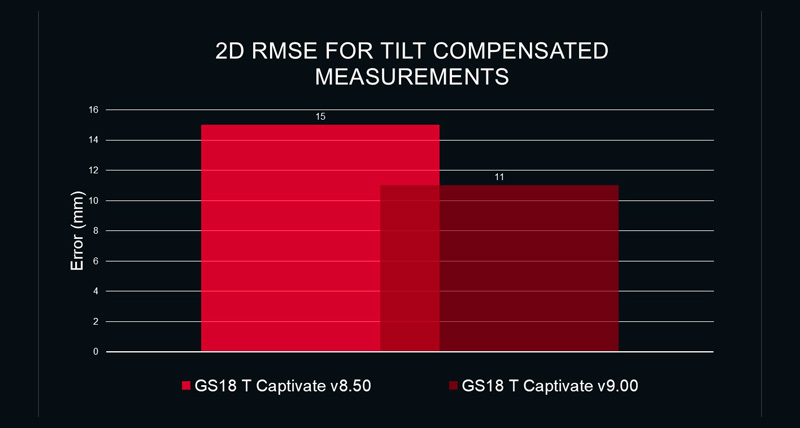
However, as great as it was at launch, the GS18 series didn’t stand still. Both the GS18 T and GS18 I have been continuously improved through Leica Captivate field software releases and algorithm updates, delivering measurable gains in accuracy, reliability, availability, and usability. These advancements ensure that all users – from early adopters to recent buyers – benefit from the latest cutting-edge technology.


.jpg?sc_lang=en-gb&hash=C2BAAC69389A909D349812C9A92E3FCD)