Caption: Langan Engineering conducts airport mapping and runway inspection with Leica TRK700 Neo.
Airside access is limited to short overnight or maintenance windows, and an airport can't pause operations for a survey crew. At major airports, closing a runway or taxiway is usually not an option, and crews working on foot among live traffic and taxiing aircraft face serious safety risks.
The ground beneath is no easier. Underground utility networks at airports are vast, with many layers of overlapping fuel lines, drainage, cabling, and ducting installed over decades by different contractors. Records of what’s down there can be incomplete, missing pipes or showing the wrong depths. Get it wrong, and a utility strike causes catastrophe by shutting down operations and endangering flight crews and passengers.
Mobile mapping solutions help solve both access and underground challenges. Pairing the Leica Pegasus TRK mobile mapping system with a vehicle-towed ground-penetrating radar (GPR), such as the IDS GeoRadar Stream UP, makes for a more efficient and safer airport survey. One drive captures the surface point cloud and the subsurface utilities together, with no need to close runways.
Airports are constantly looking to expand. They get busier every year, and that requires a steady stream of new terminals and runways. Each of those projects needs an accurate picture of what’s underground first. Mobile mapping allows utility surveying to keep pace with airport growth without disrupting operations.
Efficient airport surveys that fit your access window
Time on the ground is a scarce resource, and the TRK is designed to save it. It captures the surface and subsurface together at up to 60 km/h, so there’s no need for a second visit from a separate GPR crew.
The Stream UP’s dual-polarised antenna picks up pipes running along and across a taxiway in a single pass, where conventional GPR needs cross-hatch scanning. Both systems share one trajectory, so the datasets line up without manual alignment afterwards. Your crew stays in the vehicle rather than on foot among airside traffic.
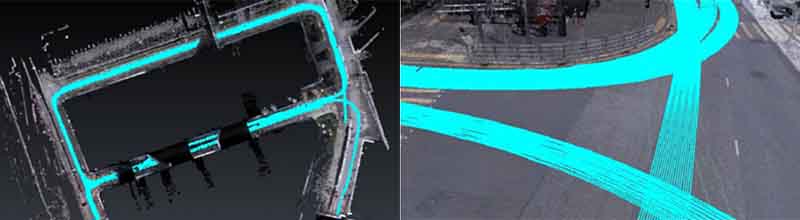
Caption: Where there have been multiple runs, the data capture is accurately aligned in post-processing.
Deliverables for airport asset management
One mobile mapping survey produces multiple deliverables that support maintenance, record management, and expansion planning.
Utility asset inventory
A georeferenced inventory of buried fire protection, water, drainage, fuel and cabling assets, tied to surface features such as manholes and valves. It gives maintenance teams one place to see what they own and where it is. The TRK captures the surface assets while Stream UP traces the pipes beneath, and because both share one trajectory they land in the same inventory without manual matching.
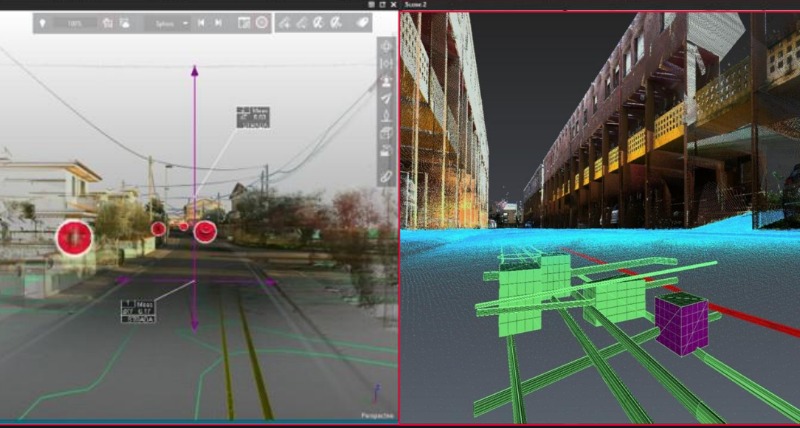
Caption: From one capture, users can see and analyse above- and below- utilities all in one environment.
Corrected utility records
Existing utility records are compared against what’s currently in the ground, showing new or unrecorded pipes, incorrect depths and positional discrepancies before a project starts. That protects new terminals and runway works from utility strikes, with fewer delays and overruns on airside projects. AiMaps, IDS GeoRadar’s cloud-based utility mapping software, accelerates pipe tracing, saving up to 50% more time across analysis and extraction.
CAD and GIS data for design teams
A digitised utility model saved as.dxf files alongside the point cloud, ready for planners and engineers. Leica Cyclone 3DR, the all-in-one software solution that transforms point cloud data into 3D models, combines the .dxf files and the TRK’s point cloud, and the results export to BricsCAD, AutoCAD or Bentley. Because the radar data is georeferenced to the same trajectory as the surface point cloud, the utility model sits in the right position in design files without re-alignment.
A shareable 3D model
Published through Leica Cyclone ENTERPRISE or Leica TruView, the 3D model lets facility managers inspect surface features, measure pipe depths and plan excavations remotely. It also serves as the base for a digital twin. Digital models stay consistent because above and below ground data come from one capture.

Caption: From one scanning pass, Geodeesia24 creates 3D models, drawings and project-specific analysis.
Utility mapping without runway closures
A 2025 project at a major international airport put this to the test. The task was to map underground utilities and scan the surface in a single georeferenced model, without closing a single road. The airport demanded 30mm accuracy, a particularly difficult ask because high buildings limited GNSS.
The team mounted a Leica Pegasus TRK500 Neo and a Stream UP on one vehicle, linked by a single sync cable. They measured the lever arm, initialised both systems and started recording.
Due to poor weather conditions and obstructed skies, standard GNSS RTK scattered widely and dropped out in places. However, the TRK’s IMU kept the trajectory continuous. Where conditions were toughest, the team added a second antenna and a DMI for extra constraint. Back in the office, they refined the trajectory in Pegasus OFFICE and used it to georeference the radar data.
The result was no runway closure cost, a simpler workflow with consistent positioning and underground features that were easy to read.
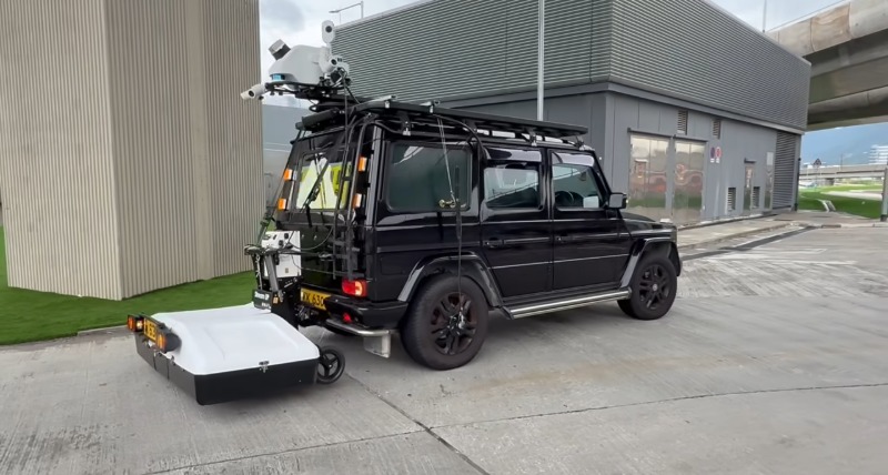
Caption: Mounted on a single vehicle, the Pegasus TRK and Stream UP capture the surface and underground utilities together
A new service for survey firms
For airport operators, mobile mapping solutions mean less disruption, safer crews and better records to support airport asset management, as well as a digital twin base for long-term planning.
Airports need accurate knowledge of what’s underneath them, without unnecessary spending and disrupted operations. Mobile mapping systems paired with vehicle-mounted GPR deliver all the information you need in one aligned dataset, quickly and safely, so surveys fit available access windows and problems surface before construction starts.
Want to find out more about airport survey solutions, including airside or large-area utility surveys? Contact the team, and learn more about the Pegasus TRK.


.jpg?sc_lang=de-de&hash=493D4107D5D9B4CED95FF15EEA8861E8)


