


Enabling city digitisation wherever you can go
Two years of city mapping completed in only 5 weeks

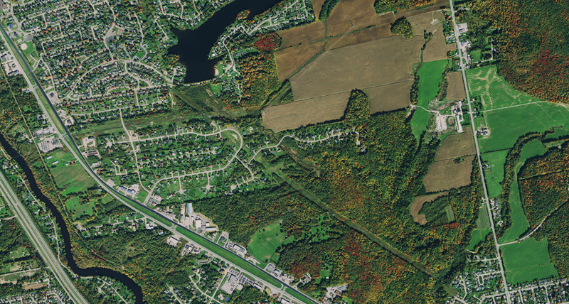
PROJECT: City mapping in the cities of Alès and Gap, France
CUSTOMER: Cabinet Brière
PRODUCT: Leica Pegasus:Backpack, Leica Pegasus:Two, Leica Pegasus:MapFactory
OBJECTIVE: Create a digital map of the two towns, Alès and Gap, to analyse their infrastructure and improve the electricity network.
Cabinet Brière was tasked with digitising the cities Ales and Gap in France to compare the two cities’ historic and modern infrastructure. Électricité Réseau Distribution France (ERDF) was going to use the two towns as standards to better understand, operate and manage the country’s electricity distribution network.
Roads, building facades and road signs were just a few of the assets surveying firm Cabinet Brière needed to map in the towns of Alès and Gap to provide a 3D digital map of the communes in southern France. ERDF contracted the 58-year-old firm known for revolutionising working methods, both in the office and in the field, with new technologies.
Combining Leica Pegasus:Two with the Leica Pegasus:Backpack the entire city was mapped in only five weeks, a project that would have normally taken two years, increasing productivity by more than 20 times.
Download the full case study for more information


Streaming service
Stream imagery using protocols like OGC WMS and WMTS directly into your application of choice, including Esri, MapInfo, Global Mapper and all proprietary oil and gas applications. Subscription fees include unlimited viewing and plotting. To learn more or receive a quote, contact our authorised resellers.
Data download
The spatial data store allows you to find and order imagery as and when you need it. Define the search method, projection, coordinate system, resolution and output file format. Within minutes your exact specified imagery can be downloaded. You can purchase imagery by credit card or apply for a business account.


Want to learn more about our mobile mapping solutions? Contact our team for more information or to request a demo.

Enabling city digitisation wherever you can go
Mobile 3D solutions for city mapping enable the interpretation of the physical world in a digital environment.

Want to learn more about the city mapping project in Alès and Gap in France? Download the full case study.

Leica Pegasus:Backpack
The wearable reality capture solution uses SLAM technology to deliver accurate indoors, outdoors and underground data for documentation and analysis.