


Лазерный 3D-сканер Leica RTC360
Используйте автоматическую предварительную регистрацию данных облака точек на объекте для оперативного контроля качества, повышения производительности и принятия более обоснованных решений прямо на месте работ

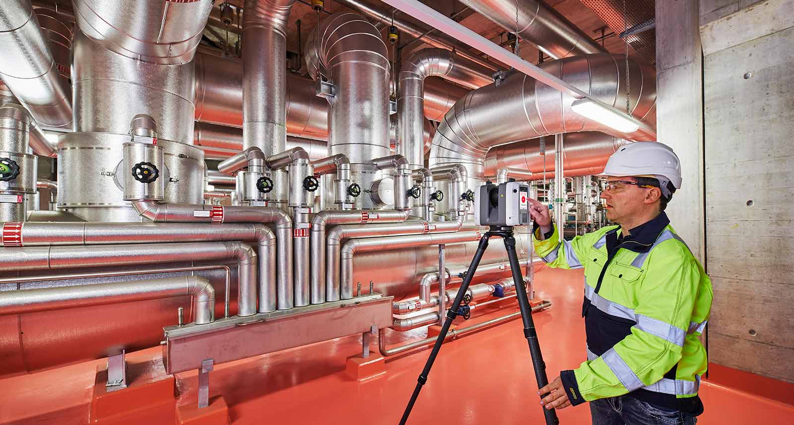
Вы сможете документировать и оцифровывать окружающую среду в 3D с помощью решения Leica RTC360 для 3D-захвата реальности. Повысьте эффективность работы на объектах и в офисе с помощью быстрого, точного, портативного и простого в использовании оборудования и ПО. С лазерным 3D-сканером RTC360 квалифицированный специалист сможет преодолеть любые проектные сложности, руководствуясь точными и достоверными 3D-моделями, и раскрыть весь потенциал любой площадки.
- Компактное, высокоавтоматизированное, интуитивно понятное и удобное решение RTC360 включает производительный лазерный 3D-сканер, мобильное приложение Leica Cyclone FIELD 360 для периферийных вычислений, например для автоматической регистрации сканируемых данных в реальном времени, и ПО Leica Cyclone REGISTER 360 для работы в офисе, с которым вы сможете легко внедрить полученную 3D-модель в рабочий процесс.
- Захват сканов, включая эффектные HDR-изображения, менее чем за две минуты.
- Автоматическая запись перемещений между точками съемки для предварительной регистрации данных сканирования на месте без ручного вмешательства.
- Дополнение собранных данных информативными тегами с подсказками по оптимальному планированию и сведениями о реальных условиях на объекте, которые помогут вашим коллегам полнее представить обстановку.
- Загружайте собранные данные из Cyclone FIELD 360 прямо в Leica TruView Cloud, чтобы оперативно обмениваться проектными данными перед импортом и регистрацией.
Быстрый
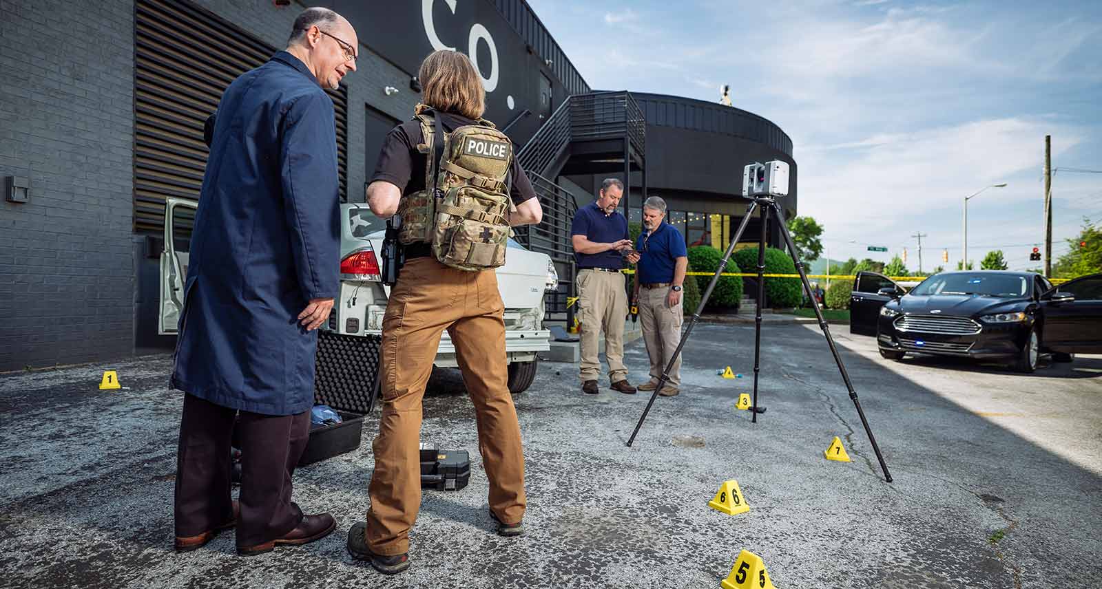
Новый лазерный сканер Leica RTC360 выполняет 3D-захват реальности со скоростью, которая была недостижима прежде. Благодаря замеру до 2 млн точек в секунду и продвинутой системе захвата HDR-изображений сканер формирует цветные 3D-облака точек менее чем за две минуты. Автоматизированная безмарочная регистрация данных в полевых условиях на основе технологии VIS и удобная автоматическая передача данных с объекта в офис дополнительно ускоряют выполнение выездных работ и повышают продуктивность.
Адаптивный
Благодаря портативной конструкции и складной треноге компактный и легкий сканер Leica RTC360 помещается в обычный рюкзак. На объекте достаточно одного нажатия кнопки, чтобы отсканировать окружение без каких-либо дополнительных настроек.
Точный
Низкий уровень шума в собранных данных означает более высокое качество изображений — вы получаете четкие детализированные сканы, готовые к применению в различных отраслях. В сочетании с ПО Cyclone FIELD 360 для автоматической регистрации данных в полевых условиях сканер Leica RTC360 обеспечивает потрясающую точность, проверить которую можно прямо на площадке.
Предварительная регистрация в полевых условиях
Приложение Cyclone FIELD 360 , входящее в состав решения RTC360, выступает связующим звеном между сбором 3D-данных на объекте и регистрацией данных лазерного сканирования в офисе с помощью Cyclone REGISTER 360. Пользователь может выполнить автоматический захват, регистрацию и контроль данных сканирования и изображений прямо на объекте. Простой в освоении и удобный графический интерфейс предлагает наглядные подсказки для сложных расчетов, благодаря чему с ним смогут совладать даже новички.


White Papers
Leica RTC360 - SLAM in Terrestrial Laser Scanning
Leica RTC360 - Image Resolution white paper
Leica RTC360 - A new approach to Terrestrial Laser Scanning white paper
Conformity Declarations
Leica RTC360 - EU Conformity Declaration
Leica RTC360 LT - EU Conformity Declaration
Sample Data
Building Construction Site 1
Building Construction Site 2
Public Safety Site 1
Public Safety Site 2
Plant - Setups 001-009 and Setups 010-015
FAST. AGILE. PRECISE. 3D Reality Capture
Leica RTC360 3D Reality Capture Solution - Plant
Leica RTC360 3D Reality Capture Solution in Budapest
Leica RTC360 Demonstration at HxGN LIVE 2018
Tech Highlight Demo: Leica RTC360
Changing the Game for Public Safety Professionals
Boosting ROI with VIS Technology
Eliminating Registration with VIS Technology
The Power of VIS Technology
Behind the Scenes
Talking RTC360 with Juergen Mayer
VR training for Public Safety
Capturing tags on-site on multiple devices
WIRED Magazine explains bullet trajectory analysis with the RTC360
Put your Plant at your fingertips with laser scanning
PortCoast - Fighting time and tide to capture a 5-hectare coastal construction site in 3D
Portcoast - Delivering precise documentation of Port Phu My with 3D laser scanning
How does laser scanning technology transform the construction industry?
JTRS - Providing high quality & timely services to customers with maximum simplicity
Советы экспертов
Discovering the power of laser scanning (Возможности лазерного сканирования)
Welcoming the RTC360 - In your words (Клиенты тепло встречают RTC360)
From hardware to software - inside Geosystems' reality capture solutions (Как создаются решения Geosystems для захвата реальности)
A New Development in Laser Scanning Technology (Новое решение для лазерного сканирования)
Behind the scenes of the fastest laser scanner on the market (За кулисами создания самого быстрого лазерного сканера)
Introducing the new Scanner Live Position feature in Cyclone FIELD 360 (Новая функция Cyclone FIELD 360 для определения положения сканера в реальном времени)
Embedding the BLK360 into the 3D Reality Capture workflow (Включение BLK360 в процесс 3D-захвата реальности)
Q&A with BLK360 specialist Andy Fontana on the Cyclone FIELD 360 app (Энди Фонтана, специалист по работе с BLK360, рассказывает о приложении Cyclone FIELD 360)
Introducing the Leica Cyclone FIELD 360 app for BLK360 (Представляем приложение Leica Cyclone FIELD 360 для BLK360)
What is the difference between the RTC360 and RTC360 LT (Разница между RTC360 и RTC360 LT)
Visual Inertial System (VIS) Technology (Визуальная инерциальная система (VIS))
Share point cloud data from Cyclone FIELD 360 to TruView Cloud (Обмен данными облака точек между Cyclone FIELD 360 и TruView Cloud)
Integrating the Leica BLK3D into the 3D Reality Capture workflow (Внедрение Leica BLK3D в процесс 3D-захвата реальности)
Introducing Check & Adjust feature for the RTC360 (Функция проверки и калибровки для RTC360)
Истории клиентов
Laser scanning from heights (Лазерное сканирование на высоте)
How Element6 delivers the future of plant engineering with laser scanning (Как лазерные сканеры помогают инженерно-строительному бизнесу Element6)
Revolutionising Smart Factories with reality capture (Использование захвата реальности на умных заводах)
Surpassing customer needs with 3D laser scanning (Системы пространственной лазерной съемки предвосхищают потребности заказчиков)
Mapping crashes and collisions at record speeds (Невероятно быстрое картографирование мест ДТП)
Using laser scanning technology for retail redevelopment (Лазерное сканирование для реконструкции торговых помещений)
Топографическая съемка и инженерное дело
How Hollis captures, processes, manages and delivers reality capture data (Технологии захвата и обработки данных и управления ими в фирме Hollis)
Surveying Germany's biggest aqua park (Исследование крупнейшего аквапарка Германии)
Возведение зданий / архитектура, инженерное дело и строительство
WD Partners achieves breakthrough in AEC as-builts with fast, agile and precise laser scanning (WD Partners моделирует здания быстро и точно путем лазерного сканирования)
Промышленные предприятия и судостроение
Revolutionising the luxury yacht industry with laser scanning (Лазерное сканирование — революция в постройке элитных яхт)
Fighting time and tide to capture a 5-hectare coastal construction site in 3D (Скоростной 3D-захват прибрежной строительной площадки)
Общественная безопасность
Changing the game for public safety professionals with the world’s fastest laser scanners (Самый быстрый лазерный сканер и общественная безопасность)
Laser Scanning Should Be Required for Every School Building; New Technology Makes It Possible (Лазерное сканирование школ)
Leica RTC360 Laser Scanner Satisfies the SAPD Collision Investigations Unit’s Need for Speed (Полиция Санта-Аны — сканер Leica RTC360 ускоряет расследование ДТП)
Castaneda Engineering Advances Accident Reconstruction with Next-Generation Reality Capture (Революционный захват реальности ускоряет реконструкцию ДТП)
Spokane PD Uses High-Speed Laser Scanning to Make Easy Work of a Daunting Seven-Acre Scene (Полиция Спокана — лазерный сканер ускоряет обследование огромного района)
Transforming reality into photorealistic Virtual Reality with laser scanning (В виртуальную реальность — через лазерное сканирование)
Объекты культурного наследия
Unveiling the mystery - an ancient water clock with laser scanning (Раскрытие тайны древних водяных часов с помощью лазерного сканера)
Preserving Romania’s speleological heritage with point cloud and GNSS data (Сохранение спелеологического памятника Румынии с помощью облака точек и ГНСС-данных)
Лазерные сканеры
Лазерный сканер Leica BLK360
Leica ScanStation P40 / P30
Leica ScanStation P50
Программное обеспечение
Leica Cyclone
Leica Cyclone REGISTER
Leica Cyclone REGISTER 360
Leica CloudWorx
Leica TruView
Leica JetStream
Аксессуары
Аксессуары для лазерных 3D-сканеров

contact-for-laser-scanning
As of v7.0.1, Safari exhibits a bug in which resizing your browser horizontally causes rendering errors in the justified nav that are cleared upon refreshing.
As of v7.0.1, Safari exhibits a bug in which resizing your browser horizontally causes rendering errors in the justified nav that are cleared upon refreshing.

The High-Definition Surveyor - Blog
Learn how Leica Geosystems laser scanning solutions are helping professional to shape the future of our world.
Learn how Leica Geosystems laser scanning solutions are helping professional to shape the future of our world.

Образовательные статьи и аналитика
Что такое 3D-захват реальности и как он применяется в вашей отрасли?
Что такое 3D-захват реальности и как он применяется в вашей отрасли?

Сравнительная таблица лазерных сканеров
Какой лазерный сканер вам подходит?
Какой лазерный сканер вам подходит?

Reality Capture Newsletter
Click here to subscribe to our regular newsletter and stay up-to-date on all the latest reality capture news.
Click here to subscribe to our regular newsletter and stay up-to-date on all the latest reality capture news.

Онлайн-обучение
Компания Leica Geosystems разработала платформу онлайн обучения для дальнейшего обучения клиентов максимальному использованию функциональных возможностей своих приборов.
Компания Leica Geosystems разработала платформу онлайн обучения для дальнейшего обучения клиентов максимальному использованию функциональных возможностей своих приборов.