Project snapshot
Contractor: Ghelma AG Spezialtiefbau (GSTB)
Location: Seon, Switzerland
Project: Mixed-use residential and commercial development
Challenge: Complex, phased excavation pit layout in difficult terrain
Solutions: Leica iCR70 robotic total stations and Leica AP20 AutoPole
Workflow: BIM-to-field layout using cloud-shared 3D models
Result: Up to 60% faster layout with improved accuracy, reduced rework and construction waste, and better office-field coordination
Key takeaways
- Shared 3D models on a cloud platform helped Ghelma AG Spezialtiefbau (GSTB) connect office planning with field layout, ensuring crews worked from the latest project information.
- Using Leica iCR70 robotic total stations and the AP20 AutoPole with a digital model, Ghelma completed layout in difficult terrain in a third of the time.
- The BIM-to-field workflows reduced labour costs, rework, downtime, and material waste while improving layout accuracy and speed.
At the outset of a mixed-use development in Seon, Switzerland, specialist foundation engineering firm Ghelma AG Spezialtiefbau (GSTB) faced layout challenges on more than one front.
First, the layout needed to be precise for the expansive and technically complex excavation pit, measuring up to 10 metres deep, 80 metres long, and 55 metres wide.
Second, an existing pharmacy remained operational on part of the site, requiring excavation to be completed in two phases. The first stage proceeded while the pharmacy remained in place, with the second beginning after the building was vacated and demolished. 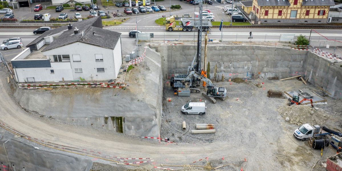
The project required GSTB to secure the excavation pit and complete the pile foundation while keeping planning and execution closely aligned, without sacrificing speed, safety, or accuracy.
For the past several years, GSTB had been expanding its digital construction workflows, and so for this project, the team applied that experience through a model-based layout approach.
Using Leica iCON solutions, including the iCR70 robotic total stations with the AP20 AutoPole, GSTB connected office-based model preparation directly with field execution.
Foremen could work from up-to-date digital models on site, changes from the office could be made available easily, and measurement points collected in the field could be fed back into the model.
The result: GSTB reduced layout time by up to 60%, improved accuracy, reduced rework and downtime, and strengthened coordination between office and field teams.
Deep, challenging excavation leaves no room for errors
Founded in 2004 and based in Switzerland, GSTB specialises in excavation support, pile foundations, protective structures, and special drilling methods. With around 180 employees and approximately 3,000 completed projects, the company has built its reputation on innovative, customised solutions for specialist foundation engineering.
For the Seon project, which included plans for a five-storey residential and commercial building with a three-storey parking garage, GSTB needed to deliver its services across two construction stages.
The scope covered approximately 30,000 m³ of excavated material, and the excavation combined multiple retaining methods to suit varying site conditions.
The project also included pile foundations and structurally demanding excavation support, requiring consistent layout accuracy throughout construction. Even a small layout error could lead to corrections, delays, and unnecessary rework. Simultaneously, the difficult terrain made traditional layout methods slower and more prone to interpretation errors.
GSTB needed a workflow that could support:
- Accurate layout in challenging terrain
- Direct use of current 3D model data in the field
- Faster communication between engineers, site managers, and foremen
- Fewer errors caused by outdated plans or misunderstandings
- Direct feedback of measurement points into the model
- Efficient reporting, quantity calculations, and checks
The goal was clear: Accelerate layout without compromising accuracy.
Connecting office planning with field execution
With support from their Lucerne-based construction technology provider, Zetech, GSTB’s workflow began in the office, where their team created a 3D model that included positions, lengths, and anchor inclinations.
The model was then uploaded to a cloud platform as part of the BIM-to-field process. On site, the foreman downloaded the model to a tablet that was connected to the iCR70 total station and AP20 AutoPole.
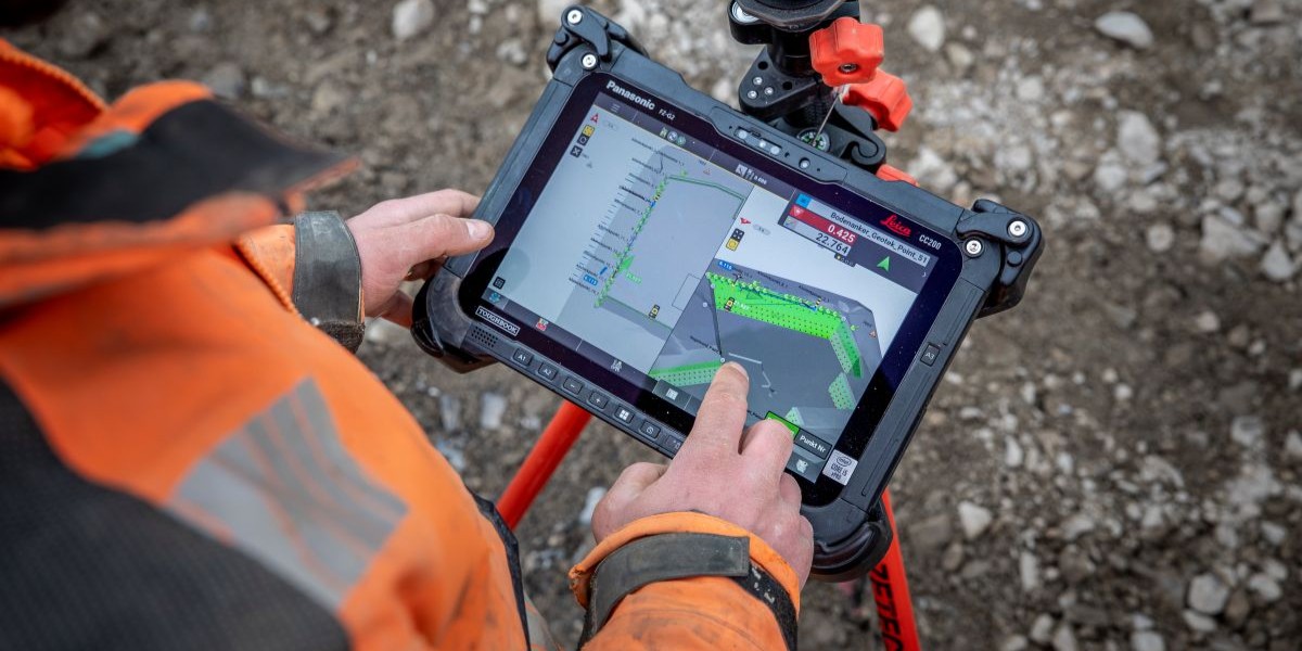
“With the Leica iCON iCR70, I can stake out directly from the digital model,” said Joel Jaun, foreman for GSTB. “I work faster and more accurately. This gives me more capacity to actively support my team on the construction site.”
For GSTB’s field teams, the digital model makes layout more visual and easier to understand. Instead of attempting to interpret paper plans, crews can work directly with the up-to-date 3D model with confidence in each layout point.
Measurement points collected in the field are also fed back into the model, where they are immediately available for checks, documentation, reports, and quantity calculations.
“The direct connection between the model and the total station greatly simplifies our processes,” said Fabian Mentzner, site manager for GSTB. “Changes to the model are immediately available on the construction site, which makes collaboration between planning and execution much more efficient and error-free.”
Because changes could be shared through the model, GSTB reduced the misunderstandings and delays that can occur when information moves through multiple handovers. As a result, field crews have the information they need when they need it, while office teams maintain visibility of what is happening on site.
Reducing rework, downtime, waste, and risk with BIM-to-field construction layout
In specialist foundation engineering, layout errors can have consequences far beyond the measurement task. Incorrect points can delay excavation support, pile foundations, and subsequent construction activities. Corrections can also increase risk for site personnel, particularly in complex excavation environments.
With the iCON solution’s automatic prism detection and the direct model connection from the office to the field, the site foremen could carry out layouts independently and precisely. This allowed the GSTB team to complete layout in a third of the time, despite the challenging terrain and complexities of the project.

Furthermore, across all layout activities, GSTB reported time savings of up to 60%, which directly reduced labour costs and freed up time for more productive construction work.
Equally important, GSTB was able to move faster while maintaining the accuracy required for this specialist foundation engineering project.
The workflow also supported more sustainable construction practices. More precise markings and more accurate quantity calculations helped to reduce material waste and construction debris, while digital processes reduced paper consumption.
Overall, the Seon project demonstrates how connected construction layout technology helps specialist foundation engineers keep planning and field execution aligned while delivering complex projects faster, safer, more sustainably, and with the accuracy they demand.


.jpg?sc_lang=de-de&hash=493D4107D5D9B4CED95FF15EEA8861E8)


