Increase surveying productivity with Leica Captivate through imaging and augmented reality

Leica Captivate empowers the Leica Viva TS16 and Leica Nova TS60 total stations as well as the Leica Nova MS60 MultiStation. All three instruments have one thing in common: comprehensive imaging capabilities. This article, along with a more detailed video, describes how imaging and augmented reality work and how these features help to overcome daily surveying challenges and in this way save time and money.
Equipment that makes surveying tasks safer and more comfortable increases productivity drastically and pays out quickly. Day-to-day difficulties like sighting steep angles or doing measurements from awkward setups cost precious time. Such situations are not uncommon to surveying professionals.
Aim the instrument without looking through the telescope
Leica Captivate’s imaging capabilities allow the instrument to be steered and aimed without looking through the telescope. Using the live view from an integrated camera, steering and aiming can be done with either the instrument’s display or remotely on the controller.
This improves and speeds up aiming in difficult situations where looking through the telescope is difficult or even impossible. In this way otherwise unfeasible tasks can be completed easily.
As all design or measurement data can be overlaid as augmented reality on the live view, quality checks can be done in real-time during measuring.
Furthermore, safety can be increased by fully operating the instrument from a distance and eye fatigue caused by repeatedly sighting through the telescope is reduced.
Looking through the telescope is not possible due to the steep measurement angle. With the inbuilt camera aiming the instrument to a corner is quick and easy.
Increases speed: Image Notes, a complete electronic field book
Have you ever experienced situations like:
- Important field information is not available back in the office
- Field notes are incomplete
- One important detail is missing
- A sketch cannot be referenced correctly, all the time whilst the time pressure is high?
Making field notes during surveying is often still done on paper, which is difficult to do in wet or windy conditions, and can easily become separated from the measurement data or become lost completely.
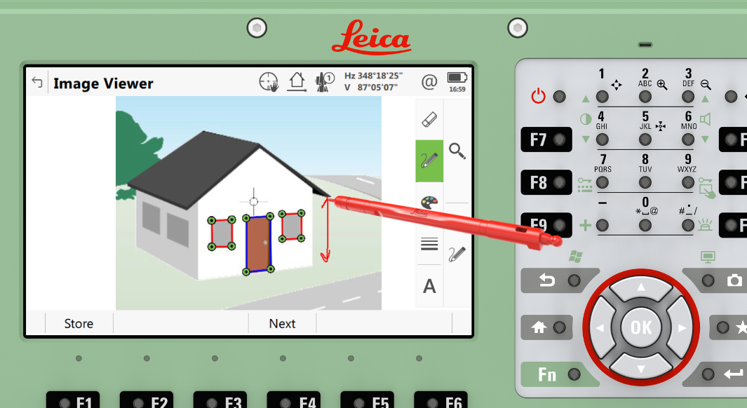
Nicely organise your field notes directly in the field: Just make a photo, sketch your notes onto the photo and link the image to the measured point.
Leica Captivate imaging and sketching tools can effectively help to overcome situations like that. By documenting points automatically with photos, those points can easily be identified back in the office. The Captivate Image Notes feature allows easy sketching directly onto the photos in the field. Any images can be directly linked to measured points, meaning field notes are nicely organised and saved along with the measurements. When transferred to the office all information is promptly available and makes the data processing much more efficient.
Reduces costly site returns: Creation of missing points in the office based on images
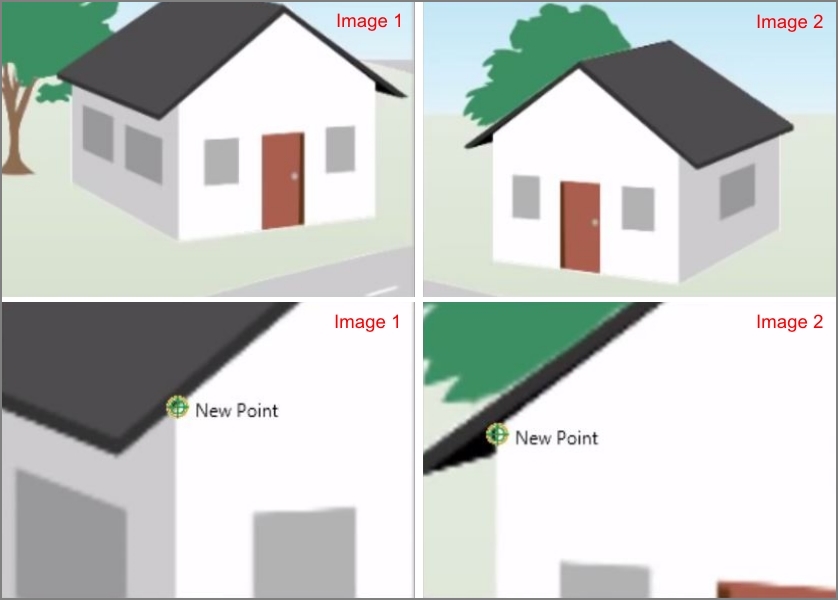
Another common situation: A measurement job is finished. Back in the office it turns out that an important point is missing. With Leica Infinity and the imaging capabilities of Leica Captivate, this problem can be solved within seconds. The only requirement is that at least two images have been captured of the missing point from different setups. Based on these images, any missing measurements can be easily and accurately created. An effective way to reduce costly site returns.
Leica Infinity: This graphic illustrates the selection of the same missing point in two photos, shot from different station setups, which then can be accurately calculated.
Watch the video
If you want to learn more about Leica Captivate’s imaging possibilities, watch this video. It describes in detail how the features work.
Paul Dainty, application engineer at
Leica Geosystems


