


QA Leica Captivate Shapefile Export App

Miguel Gomez, manager of the Leica Geosystems European Software Development Centre (SWDC), discusses the new Shapefile export app for Leica Captivate.
Q1. Could you tell us more about the SWDC?
The European SWDC is based in Madrid, Spain and is part of a network of centres around the world dedicated to providing Leica Geosystem’s customers with tailored solutions to their measurement challenges. Each centre offers a unique service within the geospatial industry, giving Leica Geosystems customers the opportunity to improve on the already impressive return on investment potential of their measurement instruments and systems purchases.
Q2. Where are the other centres based and what is their capability?
The other centres in the network are located in Montreal, Canada, Shanghai, China, in Tokyo , Japan, and Melbourne, Australia. So, we really do have global coverage. Each centre has the capability to create bespoke apps for both Leica Captivate and SmartWorx Viva so can help smooth work flow issues for most of our customers.
Q3. So your team developed the new Shapefile export app for Leica Captivate in response to a customer request?
Exactly, we were approached by a UK utility company to create the Shapefile export app to complete their filed-to-office workflow. Their surveyors are already using Leica Captivate in the field but they need to import the survey data they capture into their corporate GIS system as easily as possible.
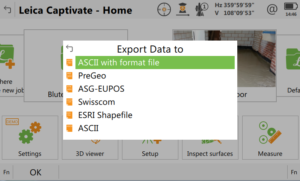
Q4. It sounds like the Shapefile export app is just what was needed to complete the workflow. How does the app integrate into Leica Captivate?
The app sits inside Leica Captivate and adds an extra option to the Export Data to pop-up menu so it is a seamless integration so users will be able to use the app straight away.
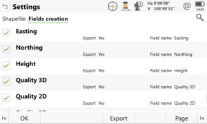
Q5. OK – but the GIS database for each customer will be different. Can the app customise the data export to match a customer’s schema?
Simple! The app guides you through the process for creating a bespoke export. It is possible to create field names based on the attribute names used in the field. You can also add fields to the exported shapefile that contain data captured by Leica Captivate such as coordinates and point quality information.
Q6. So, there is no need to use separate software to generate quality assurance information?
That’s right, all the quality information can be included in the shapefile export, which saves a lot of time. The export can also include parameters such as area, length, perimeter of features and many more. And we can, of course, always add more options should a customer require it!
Q7. Where else do you think users could utilise the app?
We have already had interest from archaeological organisations who want to survey artefacts and add them to a GIS of the dig they are working on, but the app can be used wherever there is a need to create GIS data from survey information. It means that Leica Captivate users can potentially enter new markets in asset collection for example as they can now export directly in the correct shapefile format and include all the required fields in a very easy way.
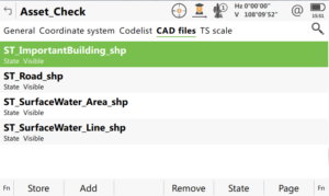
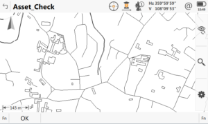
Q8. So, it could be the case that a Leica Captivate user is asked to update an asset inventory. Is it possible to load an existing shapefile into Leica Captivate so it can be viewed in the field?
Certainly, Leica Captivate can import shapefiles and use them as the background to a data capture job. Different files can be imported and made visible as required so the user can display the information relevant to that day’s work. This means that only new assets would be added to the database and no unnecessary data would be captured.
Q9. Is that difficult to setup?
No, it really is very simple. Once the data is copied to the device being used it is just a case of attaching the correct shapefile to the job via the job properties pop-up menu.
Q10. Can shapefiles created in Leica Captivate be integrated with other datasets?
Of course! Leica Infinity is the perfect tool for doing this and Infinity can also be used to prepare data for use in the field with Leica Captivate, it is a great package for this type of operation.
Q11. What tools can use this app?
This application is available in Leica Captivate. It is supported on the CS20 controller, CS35 tablet, TS16 and TS60 robotic total stations, and MS60 MultiStation. If the application is run on the CS20 or CS35, it can be used with any total station or GNSS which can be connected to either device.

Interview conducted by Tom Ridgway, Leica Geosystems EMEA TPS/GNSS solutions specialist.
Kundcase
Läs om hur kunder från hela världen drar nytta av våra mångsidiga lösningar på ett smart sätt.
Läs om hur kunder från hela världen drar nytta av våra mångsidiga lösningar på ett smart sätt.

Kontakta Leica Geosystems
Hitta dina kontaktpersoner på Leica Geosystems för frågor om försäljning, support och teknisk service.
Hitta dina kontaktpersoner på Leica Geosystems för frågor om försäljning, support och teknisk service.