By Marcel Boscenean
For many surveying jobs, GNSS is the fastest way to get from arriving on site to having coordinates. There's no instrument to set up, no line of sight to a prism to maintain, and one person can walk the site with a rover. When the job needs centimetre-level rather than millimetre-level accuracy, these practical advantages often make GNSS the natural first choice.
Confidence in GNSS has grown as the technology has evolved. More satellite constellations and signals give the receiver more to work with, and RTK performance continues to improve. Tilt compensation has also changed how surveyors use the rover. In 2017, Leica Geosystems introduced the first calibration-free, IMU-based tilt compensation receiver with the Leica GS18, a GNSS rover in the Leica Captivate portfolio, so surveyors could measure without levelling the pole and reach points that were difficult or unsafe to access. With each innovation, surveyors have been able to use high-precision GNSS positioning on more of their jobs.
But there are still places where GNSS reaches its limits. In urban canyons and under dense tree canopy, buildings and trees block some satellite signals and reflect others, degrading the quality of GNSS measurements used in RTK algorithms. Fixes can take longer, and the reported coordinate quality may not reflect actual accuracy as closely as surveyors would like.
The availability of more signals hasn’t solved this problem, because what matters is how much each signal can be trusted. A reflected signal can look perfectly valid to the receiver while causing significant biases in the calculated position.
In this expert insight, I'll explain why some GNSS signals mislead the receiver, and how we trained an AI classifier to automatically detect and mitigate those signals. I'll also cover what that means for surveyors in the field.
LOS, multipath, and NLOS: How GNSS signals reach the antenna
A GNSS signal can reach the antenna in the following ways:
- Line-of-sight (LOS): the signal travels directly from the satellite to the antenna. This is what we want.
- Multipath: the direct signal arrives, but reflected signals arrive with it and interfere.
- Non-line-of-sight (NLOS): the direct signal path[LX7.1] is blocked, but a reflection off a façade or similar surface still reaches the antenna.
Signals can also be
blocked completely by a building or other obstruction, so that the instrument simply doesn't receive them.
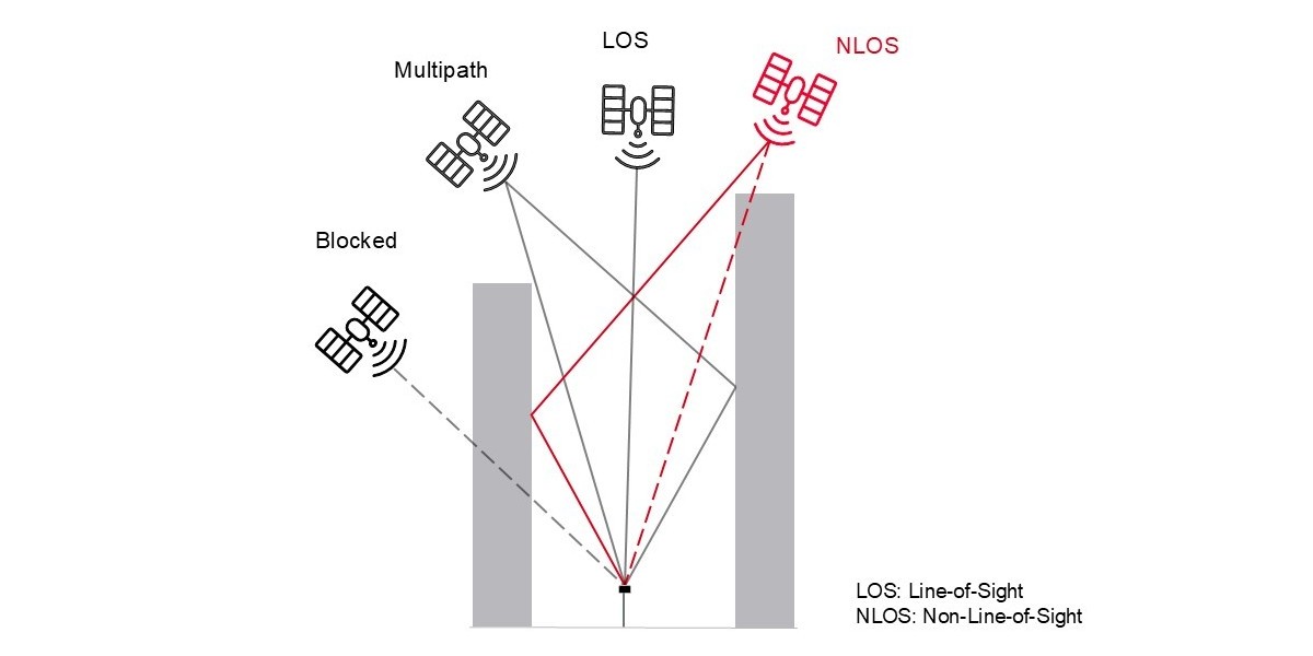
Figure 1: LOS, blocked, multipath, and NLOS signals in an urban environment. The GNSS signals arriving at the antenna can be distorted and may provide incorrect information. AI-RTK specifically addresses the NLOS signals.
Compared with multipath, NLOS errors can be an order of magnitude larger and generally have a more harmful impact on GNSS positioning performance, especially for RTK and high-precision applications. Since the direct signal is simply missing, the receiver assumes the reflected path is the direct path. A few NLOS satellites can corrupt an RTK solution, resulting in large range biases, false ambiguity fixes, and meter-level position errors.
NLOS isn't the only GNSS error source in challenging conditions, but it's an important one. This is the problem AI-RTK was designed specifically to address.
How AI-RTK identifies NLOS signals in real time
To classify a GNSS signal, it is first necessary to know the truth about it. To derive that truth, we used georeferenced panoramic cameras to label signals as LOS or NLOS based on what was actually visible from the antenna. We then trained an AI-powered classifier on representative GNSS data, taking several signal-quality features into account.
The result is a GNSS signal classifier (AI-RTK) that runs on the GS18 through a firmware update, with no new hardware or option key required. AI-RTK looks at several characteristics of each signal in real time and identifies whether it's LOS or NLOS, with approximately 90% classification accuracy. The RTK algorithm then mitigates the effect of the problematic signals on the positioning results.
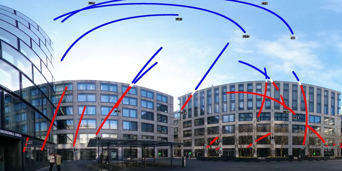
Figure 2: A panoramic image showing signals classified as LOS (blue) and NLOS (red). The white segments indicate unclear or transition signals.
What changes when you're holding the rover?
The GS18 rover already performs well in many difficult environments, thanks to its high-performance positioning engine and its multipath and interference mitigation capabilities. AI-RTK takes that a step further, extending the range of places where you can get high-precision GNSS performance.
Statistical analysis of globally collected data, combined with use-case testing, shows three key benefits of AI-RTK.
1. Faster time to fix
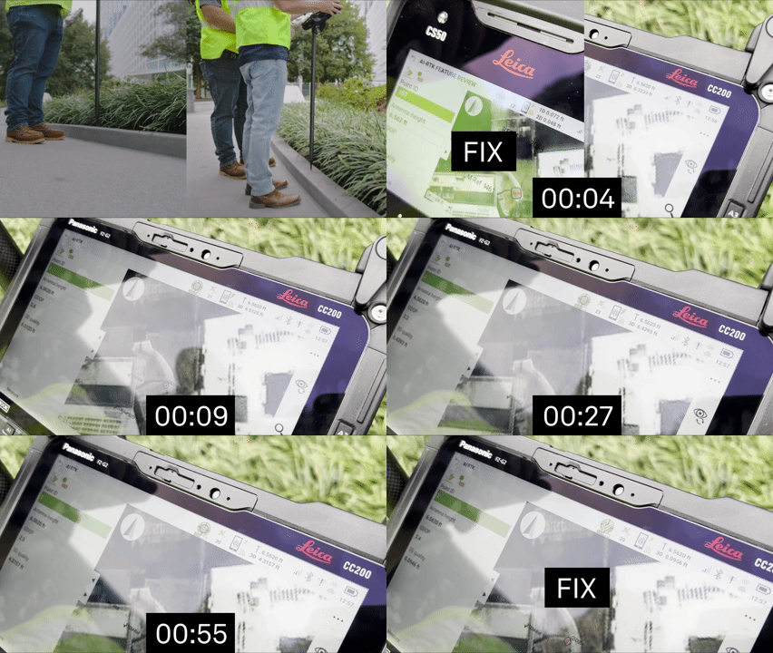
In difficult conditions, AI-RTK helps the receiver move from a code-based differential solution (DGNSS) to an RTK fixed solution more quickly; tests have shown up to a 30% improvement in time to fix. Those saved seconds for each RTK fix add up over the working day, enabling you to spend less time waiting and more time measuring.
Figure 3: In a side-by-side test of a GS18 receiver with AI-RTK on (left) and AI-RTK off (right) in downtown Atlanta, Georgia, USA, AI-RTK provided a significantly faster time to fix.
2. An RTK fix in more places
AI-RTK extends the range of places where you can get an RTK fixed solution, the best result a GNSS rover can deliver. The benefit is greatest where the sky is partly blocked, in areas close to buildings, in narrow streets, and under trees. When the GS18 reaches a fix, the accuracy is already very good. AI-RTK helps you reach that fix in more of the places where you need it.
3. A quality value you can trust
With AI-RTK enabled, the coordinate quality (CQ) shown in Captivate field software is closer to the accuracy actually achieved. When the CQ shows 5 cm, you can rely on that value with even greater confidence to decide whether a measurement is fit for the job.
Measurable gains in a demanding test
In one demanding test, an RTK survey with tilt compensation was performed in an urban part of Davos, Switzerland. With AI-RTK, the horizontal, vertical, and 3D root mean square (RMS) errors were reduced by up to 36%. We saw improvements in both static and kinematic tests, with and without tilt compensation.
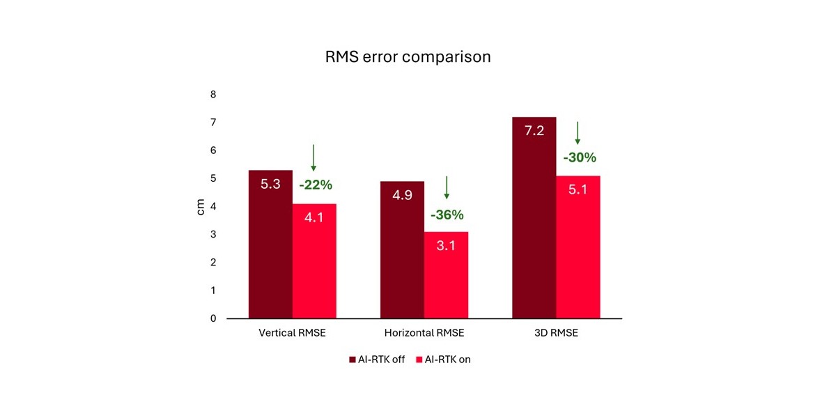
Figure 4. Positioning error (RMSE) with and without AI-RTK in an RTK test with tilt compensation in an urban environment in Davos, Switzerland. Lower values indicate better accuracy.
Additional insights
AI-RTK extends where GNSS can deliver reliable results. However, it doesn't change the physics. A sufficient view of the sky or number of satellites is still needed for RTK positioning. In addition, AI-RTK performs best with multi-GNSS and multi-frequency rover observations and RTK corrections.
Since the characteristics of NLOS signals are site-specific, the effects of AI-RTK on positioning results are also location-dependent. In places where high-precision GNSS RTK is not possible or millimetre-level accuracy is required, the total station remains the best instrument.
Better information for better surveying decisions
The development of GNSS has often been about collecting more satellites, more signals, and more frequencies. AI-RTK reflects a shift from collecting more information towards using it more intelligently and efficiently.
That doesn't take the judgement out of surveying. You still evaluate the result, check the quality, and decide whether a measurement is fit for the job. The goal is to give you better information faster to base that judgement on, so you're ready for more of the conditions you actually work in, not just the ideal ones.
How to get AI-RTK
AI-RTK is available on Leica GS18 receivers through the GNSS firmware update released alongside the latest version of Leica Captivate field software. Contact your local Leica Geosystems representative to check availability and update requirements.
Marcel Boscanean, Product Engineer, Leica Geosystems