Surveying technology continues to become more capable, but productivity is often shaped by something more familiar: the tasks crews repeat on nearly every job.
Project setup. Coding. Linework. Stakeout. Measurements. Checks before leaving the site. Moving data back to the office. These routine steps fill much of the working week, and when they are slow, unclear, or inconsistent, small inefficiencies can turn into return visits, rework, and lost time.
We asked Irina Lungu, product manager for Leica X-PAD at Leica Geosystems, part of Hexagon, why everyday surveying workflows deserve more attention, where teams still lose time, and how Leica X-PAD is designed to help.
Surveying technology keeps getting more capable. Why focus on everyday workflows?
There is always interest in the most advanced applications, but many teams spend much of their time on tasks they perform again and again: setting up projects, connecting instruments, coding, creating linework, staking out points and lines, checking measurements, and getting data back to the office, for example.
When those steps are easy to follow, crews spend less time searching for functions, checking work after the fact, or correcting avoidable gaps.
That is why it is worth looking closely at the daily workflow, not only at the next new capability.
Where do teams lose the most time in those everyday jobs?
Often, it’s small things, such as having to work through different steps from one job to another, spending too much time finding the right function, retraining people, or discovering later that something was missed in the field.
Those things may only cost a few minutes at a time, but across a lot of jobs and a lot of people, they add up. Return visits are an obvious example. If the team gets back to the office and realises that one important point is missing, that can cost much more than the original measurement.
How much of that is a software problem rather than a hardware problem?
It is both, but the workflow around the hardware is very important.
You can have an excellent instrument, but people still need a clear way to use it for the task in front of them.
The software is what guides the surveyor or measurement professional through that work. It is where you set up the job, choose what you are measuring, code it, visualise it, check it, and move the data to the next step.
So we do not view software as separate from the instrument. The value comes from how the whole workflow works together.
Is that the problem Leica X-PAD is designed to address?
Leica X-PAD is about making routine surveying and measurement work easier to move through.

That is what we mean by a focus on performance: giving teams the capabilities they need for common field tasks, then organising those capabilities so the path from setup to handover is clear.
The Leica GS11, a visual GNSS RTK smart antenna, is the main new instrument in this launch. It works as part of a broader Leica X-PAD workflow that connects field software and supported GNSS and total station instruments. It also includes office workflows in Leica X-PAD Fusion, and services such as Hexagon GeoCloud and Hexagon SmartNet.
The aim is not to give people every possible option. It is to make the capabilities they use most often easier to access and apply.
What is required to achieve consistency?
Not every crew has the same level of experience, and not every person uses the software in exactly the same way.
If the workflow is familiar from one job to the next, it becomes easier to train people and easier to move them between projects.
Visual technology is becoming more common in surveying. Where does it genuinely help?
Visual surveying technology is most valuable when it makes the work easier and provides more clarity for surveyors or measurement professionals in the field.

Coordinates and numbers are essential, but sometimes the fastest way to understand what is happening is to see the information in a visual format. When survey data can be viewed against the real site, it becomes easier to spot something that does not look right or a measurement you may have missed.
That matters because the cost of a missed point is rarely just the measurement itself. It can mean sending a crew back, interrupting the schedule, and delaying the next step in the workflow.
How does that work with the Leica GS11 and Leica X-PAD?
Visual workflows are already familiar to surveyors who use X-PAD field software. They’re used to pulling in map data and CAD drawings with points and linework collected in the field, and switching between 2D and 3D views to verify captured points. With the GS11, Leica X-PAD unlocks the capabilities of the sensor to add imagery and AR guidance as part of the workflow.
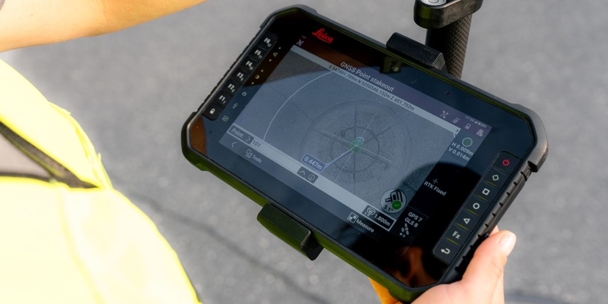
In stakeout, for example, guidance from the cameras can be shown over the live image of the site in Leica X-PAD. That gives you a much more immediate sense of where you need to go next.
You can also capture images and measure points from those images. That can help when a point is difficult or unsafe to occupy directly, or when you realise you need an additional point after you have already taken the image.
If you’re measuring remotely, you can use the instrument’s laser distance meter to see the laser point in the camera view.
The idea is to give teams more ways to measure difficult points, check work, and reduce avoidable gaps before leaving the site.
Other capable GNSS receivers and Android surveying apps are available. What should professionals look for when comparing them?
The receiver specification is only one part of the decision. Professionals should also look at the workflow around it: whether GNSS and total station work feel familiar, how data moves after it leaves the field, what positioning services and support sit behind the product, and whether the solution can still fit as the business grows.
There are many capable GNSS receivers in the market today, so comparing specifications only gets you so far. The better question is how well the receiver fits into the complete way your team works.
Does a more focused workflow mean giving up capability?
Leica X-PAD supports GNSS and total station work, coding, linework, calculations, stakeout, drawings, surfaces, and models. Those capabilities are organised around the workflows people use regularly.
Focus means making those capabilities easy to find and straightforward to use, so surveyors can get into the task, understand what comes next, and keep the job moving.
When evaluating surveying solutions, how should a company decide how much capability it really needs?
Some organisations need to be ready for a very broad range of surveying applications, including highly specialised work. Others spend much more of their time on repeatable surveying and measurement tasks and want the most direct way through that work. That is one reason Leica Geosystems offers different field software approaches.
The useful question is not, “Which one has more features?” It is, “Which one fits the way this team works?”
Does Leica X-PAD replace any of Leica Geosystems’ existing surveying solutions?
No. Leica X-PAD gives us another way to meet different kinds of surveying and measurement work.
Leica Geosystems now has four field software solutions: Leica X-PAD, Leica Captivate, Leica iCON and Leica Zeno They are designed around different kinds of work rather than being versions of the same thing.
Leica X-PAD is focused on the surveying and measurement workflows crews perform regularly. Captivate gives surveyors a broader range of capabilities and the flexibility to take on very different kinds of projects, while iCON is built around construction workflows. And Zeno is designed for high-accuracy GIS workflows.
The right question is not which platform is best, but which one best fits the team’s work.
Can Leica X-PAD be used with every Leica Geosystems instrument?
Not every instrument, because we are building X-PAD around combinations that make sense for the work it is designed to do.
At launch, the Leica X-PAD offering includes the GS11 and GS05 GNSS smart antennas and the TS13 robotic total station, alongside supported GeoMax instruments. The GS05 and TS13 can also be used with Captivate.
That is deliberate. The aim is to match the hardware, software, and services to the kind of work the team needs to complete, rather than treating each choice separately.
What does this mean for people who already use GeoMax X-PAD?
The important point is continuity. GeoMax X-PAD becomes Leica X-PAD, but the software experience people know stays familiar. The interface and workflows continue, and compatible GeoMax instruments continue to work with X-PAD.

Active Customer Care, existing service agreements, and subscriptions also continue. So people are not being asked to relearn the way they work. What changes is that X-PAD now sits within Leica Geosystems, with access to a broader set of Leica Geosystems technology and services over time.
If you had to sum up why everyday surveying workflows deserve more attention, what would you say?
Everyday workflows are where consistency, confidence, and productivity are built across the whole team. If you can make setup clearer, stakeout easier to follow, measurements easier to check, and field-to-office handover more consistent, those practical improvements can have a significant cumulative impact.