


Maintaining Danish Highways Driving operational efficiencies
Highways Maintenance Dramatic increase in public safety

Author: Simon Hall
A national road network is one of the most important pieces of infrastructure any country will ever built and maintain. Ensuring that these public highways are kept to the highest possible standard results in a dramatic increase in public safety, however it is possible for some roads are not kept to the standards required.
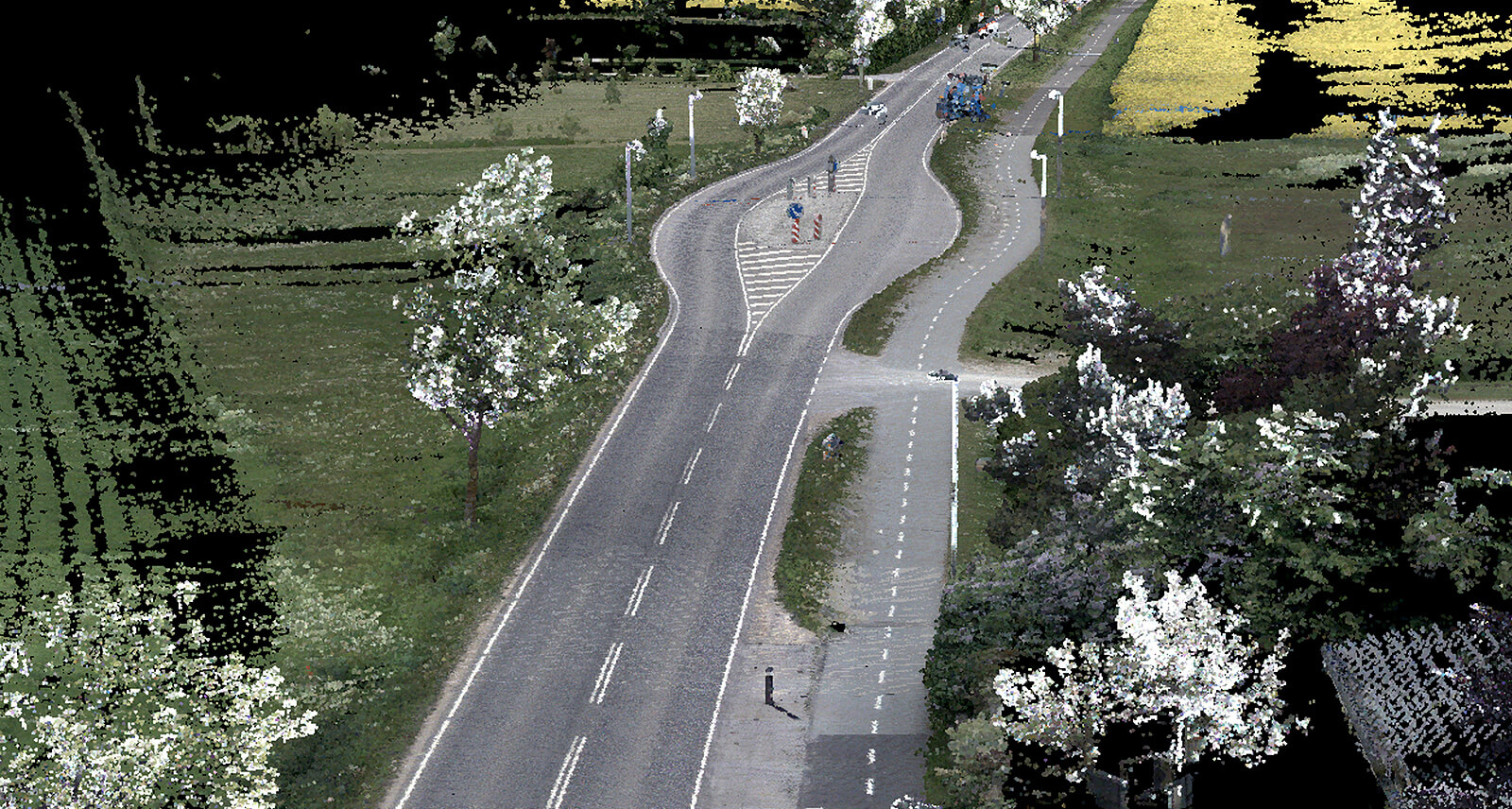
With over 11,000km of dual carriageway roads, along with several thousand more smaller roads, the Danish Road Directorate (Vejdirektoratet) contracted Getmapping after a tendering process to survey the road state network. High density terrestrial point cloud data and matching high resolution panoramic imagery would be collected using the state-of-the-art Leica Pegasus: Two Mobile Mapping Ultimate equipment.

Getmapping PLC is a leading global provider of geospatial data and survey solutions. They have over 20 years’ experience in the capture and delivery of high-resolution aerial imagery, LiDAR, digital mapping and web-based services across Europe and Africa. Their goal is to enable the timely and cost-effective delivery of geospatial data, creating digital replicas of the world. Getmapping collects, transforms, stores and delivers scalable geospatial data, mapping and modelling solutions to enable better decision making. By creating true digital replicas of the environment, their aim to empower their customers and partners to create solutions to the challenges facing their business and the planet.
Vejdirektoratet, or the Danish Road Directorate, is responsible for the national road network of Denmark, which comprises motorways, several main roads and many of the country’s bridges. They create coherence for the many road users who use the Danish state roads every day. They accomplish this by developing, planning and constructing Denmark’s infrastructure and bind the country together. It requires solutions that balance mobility, the environment and road safety.
About the Project
Despite having some of the safest road in Europe with only 30 deaths per million inhabitants in 2020 , the goal of Vejdirektoratet was to scan the 11,000 km of road networks across the country using the Leica Pegasus: Two Mobile Mapping Ultimate solution, enabling them to collect high density terrestrial point cloud data and matching high resolution panoramic imagery.
“This is an exciting project for Getmapping. Denmark is a new market for us and expands our presence as the leading supplier of aerial and mobile mapping services across North-West Europe.”
Gavin Sullivan | Deputy Head of Europe – Getmapping, United Kingdom
Within 6 months of the contract award, Getmapping were scheduled to have delivered a full dataset of 3D laser point clouds and 360-degree photos to the Danish Road Directorate, covering all state roads and their immediate surroundings.
Challenges
Several challenges faced the Getmapping team in the build up to the project. The scale of the project was one of the largest Mobile Mapping projects ever undertaken by Getmapping, with more than 11,000 line kilometers to cover. The extensive data processing and classification requirements, including image anonymisation, 4 classes of LiDAR classification, and the timescales, requred Getmapping to deliver of the fully processed data set, including data capture, in less than 6 months.
“Covid19 and Brexit are already the ‘new normal’ at Getmapping and are included and considered in all our activities. The biggest challenge for this project was the tight deadline to capture, process and classify such a large amount of data in such a short amount of time: something that has never been done before! The project was made possible by identifying the duration and dependence of each task and dedicating adequate team management to each one of them. ”
Alexandre Alves | European Operations Manager – Getmapping, United Kingdom
Despite the challenges – the scale, extensive data processing and short execution period, Getmapping delivered the clients expectations:
- Highly efficient data capture, which meant the data only had to be captured once to meet the project specifications
- Hundreds of line kilometres captured per day ensured all mapping was completed within 3 months of the project start date
- The mobile mapping data, including classifications was processed and delivered in phases, providing usable and relevant information for immediate consumption and analysis
- The full data set was delivered within the required 6 month deadline
Mobile mapping solution
With the Leica Pegasus:Two Ultimate mobile mapping solution, Getmapping were able to use the laser scanners in combination with GNSS receivers, IMU and a DMI, acquiring accurate and precise spatial data with cameras mounted on their vehicle.
The innovative mobile sensor platform captured the required point cloud and imaging data. The multi-sensor approach allowed Getmapping to increase their ROI by collecting more data in one pass, decrease their time in the field and
generate higher results with the same resources. The reality capture solution is completely vehicle-independent, making it a competent solution across multiple applications without limiting users to road and rail.
Getmapping only needed to capture the data once surpassing the project specifications with respect to point density and expected data accuracy, keeping their employees safe and decreasing their time in the field. The Pegasus:Two captured
the full 360° spherical view imaging and LiDAR together, meaning Getmapping would not have to return to a specific project site once the data had been captured.
A view to the future
The Leica Pegasus:Two Ultimate was the best option for the project. Using this mobile mapping system, it took less time and was more cost effective than any other surveying method to achieve this level of detail and accuracy. The data also drove operational efficiencies, enabling the Vejdirektoratet employees to carry out visual inspections and measurements from the office, mitigating the health and safety risks of site visits. The new data will also allow them to develop completely new methods and applications in a wide range of areas.
“Getmapping have a strong focus on collaboration. For projects like this, the benefits of this consultative approach went beyond the provision of best of breed technology, to how we collectively provided our customer with high quality business insights, effectively and efficiently.”
Helen Wattie | European Sales Manager – Getmapping, United Kingdom
Getmapping are now actively marketing for other bespoke survey opportunities using the Pegasus:Two, and this project showcases the extent of the surveying that they can provide.
Over the last 12 months they have worked with a rapidly increasing number of customers who are looking for a faster,safer, cost effective alternative to traditional topographical survey techniques, and their Mobile Mapping solution is being used in a variety of new and innovative ways including Highways Planning, Asset Management, Monitoring Changes, Parking Apps, 3D Modelling and Artificial Intelligence.

Kontakt oss om laserskanning i dag!
Ta kontakt med oss for mer informasjon om vår laserskanningsportefølje.

Laser Scanning i Industrien
Med introduksjonen av laserskanning er måling og dokumentering forenklet og forbedret i alle bransjer.